|
| Mesoscale Discussion 506 |
|
< Previous MD Next MD >
|
|
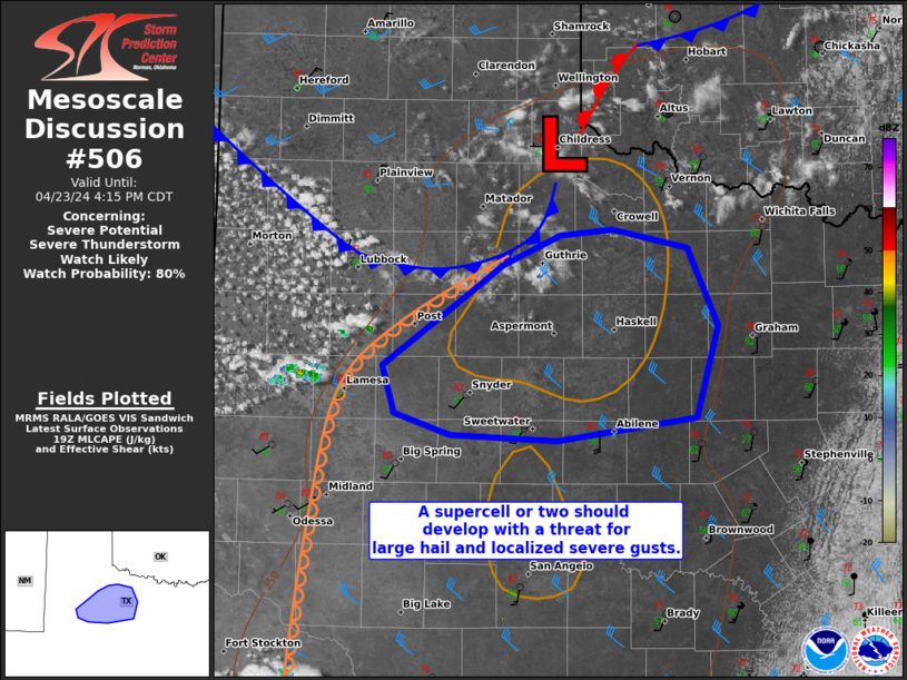
   Mesoscale Discussion 0506
   NWS Storm Prediction Center Norman OK
   0239 PM CDT Tue Apr 23 2024

   Areas affected...western North to Big Country of TX

   Concerning...Severe potential...Severe Thunderstorm Watch likely

   Valid 231939Z - 232115Z

   Probability of Watch Issuance...80 percent

   SUMMARY...A supercell or two should develop across a portion of
   western North Texas and the Big Country during the late afternoon.
   Large hail of 1.5 to 2.5 inches in diameter and localized severe
   gusts of 60-70 mph will be possible.

   DISCUSSION...A high-based CU and small CB field is increasing in the
   well-mixed post-dryline air across the TX South Plains. This
   activity will likely further deepen as it spreads east and impinges
   on the upper 50s to low 60s surface dew points prevalent across
   parts of the Big Country and Low Rolling Plains of western North TX.
   Initially weak low-level flow beneath moderate mid to upper-level
   west-northwesterlies will favor some elongation and nearly straight
   hodographs. This should support potential for splitting supercell
   structures. Midday model guidance is consistent with earlier 12Z
   runs in simulating a sustained supercell or two into early evening.
   This will probably remain anchored near the southward-sagging
   surface front prior to it stalling later this evening. Large hail
   should be the primary hazard, but locally strong to severe gusts
   will be possible as well.

   ..Grams/Smith.. 04/23/2024

   ...Please see www.spc.noaa.gov for graphic product...

   ATTN...WFO...FWD...OUN...SJT...LUB...MAF...

   LAT...LON   33600065 33800016 33859974 33719911 33189886 32539905
               32370019 32410107 32570153 32890164 33450085 33600065
|
|
Top/All Mesoscale Discussions/Forecast Products/Home
|
|


 @NWSSPC