|
| Mesoscale Discussion 507 |
|
< Previous MD Next MD >
|
|
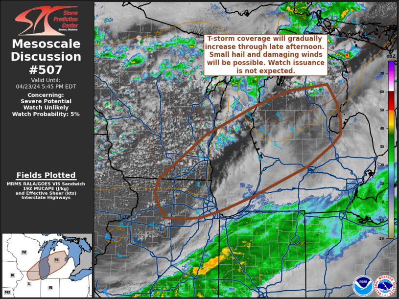
   Mesoscale Discussion 0507
   NWS Storm Prediction Center Norman OK
   0252 PM CDT Tue Apr 23 2024

   Areas affected...Northeast Illinois and southeast Wisconsin into
   central Lower Michigan

   Concerning...Severe potential...Watch unlikely

   Valid 231952Z - 232145Z

   Probability of Watch Issuance...5 percent

   SUMMARY...Isolated to scattered thunderstorms will continue to
   develop across the Great Lakes region. A few strong to severe storms
   are possible with small to marginally severe hail and damaging winds
   as the primary hazards. Coverage of severe storms should remain
   sufficiently limited to preclude watch issuance.

   DISCUSSION...Isolated to scattered thunderstorms have been ongoing
   over eastern WI, the Upper Peninsula of MI, and northern WI over the
   past several hours with multiple reports of 0.5 to 0.75 inch hail
   and 35-45 knot gusts noted. This convection has largely been driven
   by ascent along and ahead of a secondary cold frontal surge where a
   combination of modest diurnal warming and cold temperatures aloft is
   supporting MUCAPE between 250-500 J/kg. This trend is expected to
   continue downstream into IL/MI as the cold temperatures aloft
   overspread the region and mid/upper-level cloud cover slowly shifts
   southeast. Based on recent observations and RAP forecast soundings,
   around 500 J/kg MUCAPE should be feasible as surface temperatures
   warm into the upper 60s. Weak mid-level winds to the north of a jet
   streak over IL/IN/OH have limited storm longevity/organization thus
   far, but destabilization closer to the stronger mid-level flow may
   promote higher, though still somewhat meager, effective bulk shear
   values between 20-25 knots. This should support better storm
   organization with a higher potential for marginally severe hail (0.5
   to 1.0 inch) and localized damaging wind gusts (most likely between
   40-50 knots). Latest mesoanalysis suggests a higher buoyancy axis
   exists from southeast WI into west-central/northern Lower MI, so the
   severe threat may be maximized across this corridor in the coming
   hours. However, severe thunderstorm coverage should remain limited
   given the overall marginal kinematic environment.

   ..Moore/Smith.. 04/23/2024

   ...Please see www.spc.noaa.gov for graphic product...

   ATTN...WFO...DTX...APX...IWX...GRR...LOT...MKX...DVN...

   LAT...LON   42488950 43578801 44268639 44628527 44778397 44328368
               43908355 43568358 43318386 42828463 42128642 41808735
               41608809 41558865 41568906 41568926 41978954 42178960
               42488950
|
|
Top/All Mesoscale Discussions/Forecast Products/Home
|
|


 @NWSSPC