View What is a Watch? clip.

   ZCZC SPCPWOSPC ALL
   WOUS40 KWNS 291647
   IAZ000-KSZ000-MOZ000-NEZ000-300200-

   PUBLIC SEVERE WEATHER OUTLOOK
   NWS STORM PREDICTION CENTER NORMAN OK
   1147 AM CDT SUN JUN 29 2014

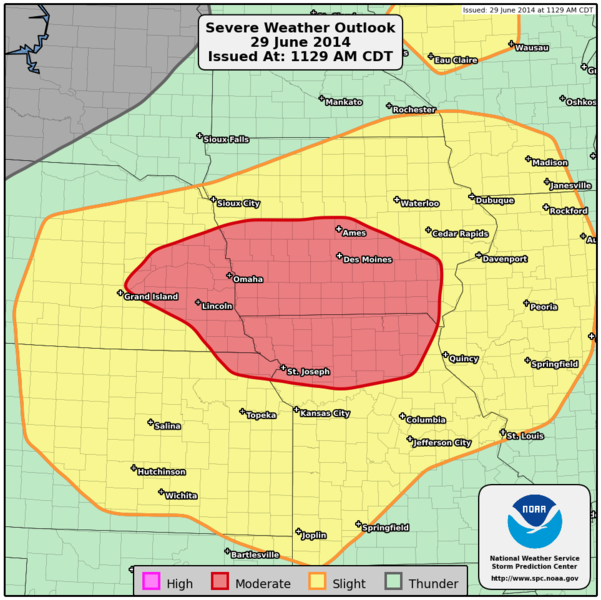
   ...Severe thunderstorms expected over parts of the central Plains
   into the middle and upper Mississippi Valley this afternoon,
   evening, and overnight...

   * LOCATIONS...
     Southern Iowa
     Northern Missouri
     Northeastern Kansas
     Eastern Nebraska

   * HAZARDS...
     Widespread damaging winds, some hurricane force
     A few tornadoes
     Widespread large hail, some baseball size

   * SUMMARY...
     Severe thunderstorms capable of very large hail, a few
     tornadoes, and swaths of damaging wind are possible this
     afternoon and tonight over parts of the Central Plains and the
     mid and upper Mississippi Valleys.

   Preparedness actions...

   Review your severe weather safety procedures for the possibility
   of dangerous weather today. Stay tuned to NOAA Weather Radio,
   weather.gov, or other media for watches and warnings. A watch
   means that conditions are favorable for severe thunderstorms
   over the next several hours. If a severe thunderstorm warning is
   issued for your area, move to a place of safety, ideally in an
   interior room on the lowest floor of a sturdy building.

   &&

   ..Marsh.. 06/29/2014

   $$