View What is a Watch? clip.

   ZCZC SPCPWOSPC ALL
   WOUS40 KWNS 261646
   IAZ000-ILZ000-INZ000-MOZ000-270200-

   PUBLIC SEVERE WEATHER OUTLOOK
   NWS STORM PREDICTION CENTER NORMAN OK
   1146 AM CDT SAT JUL 26 2014

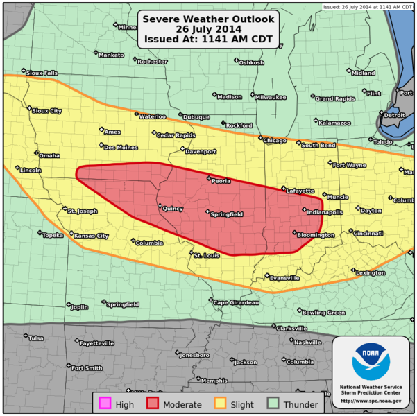
   ...Severe thunderstorms expected over parts of the Select a General
   Area this afternoon and tonight...

   * LOCATIONS...
     Central Illinois
     Central and Southern Indiana
     Northern Missouri
     Southern Iowa

   * HAZARDS...
     Widespread damaging winds
     A couple of tornadoes
     Scattered large hail, some baseball size

   * SUMMARY...
     Severe storms, some accompanied by very large hail, damaging
     gusts and a couple of tornadoes are expected later this
     afternoon into tonight from eastern Nebraska to parts of the
     middle Mississippi and lower Ohio Valleys. The most concentrated
     risk area appears to be this evening into tonight from southern
     Iowa and northern Missouri, across central Illinois, and into
     central/southern Indiana, where one or more organized
     thunderstorm clusters could produce swaths of damaging winds.
     The damaging wind risk could reach as far as southern Ohio and
     northern Kentucky overnight.

   Preparedness actions...

   Review your severe weather safety procedures for the possibility
   of dangerous weather today. Stay tuned to NOAA Weather Radio,
   weather.gov, or other media for watches and warnings. A watch
   means that conditions are favorable for severe thunderstorms
   over the next several hours. If a severe thunderstorm warning is
   issued for your area, move to a place of safety, ideally in an
   interior room on the lowest floor of a sturdy building.

   &&

   ..Hart.. 07/26/2014

   $$