   ZCZC SPCPWOSPC ALL
   WOUS40 KWNS 130850
   ARZ000-ILZ000-KYZ000-LAZ000-MOZ000-MSZ000-TNZ000-131800-

   PUBLIC SEVERE WEATHER OUTLOOK
   NWS STORM PREDICTION CENTER NORMAN OK
   0350 AM CDT MON OCT 13 2014

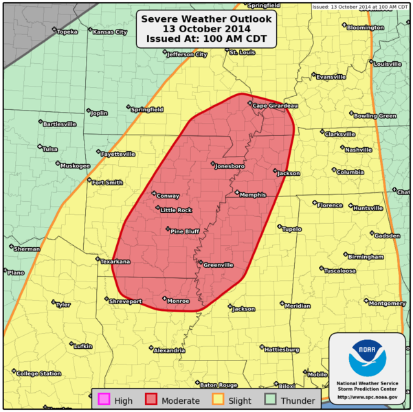
   ...Severe thunderstorms expected over parts of the Mid South and
   Lower Mississippi Valley today...

   * LOCATIONS...
     Central and eastern Arkansas
     Western and northern Mississippi
     Western Tennessee
     Northern Louisiana
     Southeastern Missouri
     Western Kentucky
     Southern Illinois

   * HAZARDS...
     Widespread damaging winds, some hurricane force
     A few intense tornadoes
     Isolated large hail

   * SUMMARY...
     Strong to severe thunderstorms are expected today and tonight
     from East Texas through the lower and middle Mississippi Valley
     into parts of the Tennessee Valley, Ohio Valley and Gulf Coast
     states. Widespread damaging winds and a few tornadoes are
     likely, especially over the Mid South and Lower Mississippi
     Valley regions today.

   Preparedness actions...

   Review your severe weather safety procedures for the possibility
   of dangerous weather today. Stay tuned to NOAA Weather Radio,
   weather.gov, or other media for watches and warnings. A watch
   means that conditions are favorable for severe thunderstorms
   over the next several hours. If a severe thunderstorm warning is
   issued for your area, move to a place of safety, ideally in an
   interior room on the lowest floor of a sturdy building.

   &&

   ..Edwards.. 10/13/2014

   $$
|
