View What is a Watch? clip.

   ZCZC SPCPWOSPC ALL
   WOUS40 KWNS 130754
   IAZ000-ILZ000-INZ000-KYZ000-OHZ000-131800-

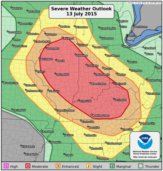
   PUBLIC SEVERE WEATHER OUTLOOK
   NWS STORM PREDICTION CENTER NORMAN OK
   0254 AM CDT MON JUL 13 2015

   ...Severe thunderstorms expected over parts of the Midwest and Ohio
   Valley later today and tonight...

   * LOCATIONS...
     Illinois
     Kentucky
     Indiana
     Southwestern Ohio
     Far eastern Iowa

   * HAZARDS...
     Widespread damaging winds, some hurricane force
     A few intense tornadoes
     Scattered large hail, some baseball size

   * SUMMARY...
     Multiple rounds of severe thunderstorms capable of damaging
     winds, tornadoes and large hail are likely today and tonight
     across parts of the Midwest and Ohio Valley, but especially
     across portions of Illinois, Indiana, Kentucky and southwestern
     Ohio.

   Preparedness actions...

   Review your severe weather safety procedures for the possibility
   of dangerous weather today. Stay tuned to NOAA Weather Radio,
   weather.gov, or other media for watches and warnings. A watch
   means that conditions are favorable for severe thunderstorms
   over the next several hours. If a severe thunderstorm warning is
   issued for your area, move to a place of safety, ideally in an
   interior room on the lowest floor of a sturdy building.

   &&

   ..Gleason.. 07/13/2015

   $$