The SPC is forecasting ...Severe thunderstorms expected over parts of the overnight....
Please read
the latest public statement about this event. View What is a Watch? clip.
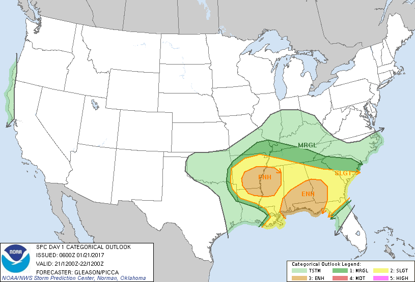
Categorical Graphic
Day 1 Risk
Area (sq. mi.)
Area Pop.
Some Larger Population Centers in Risk Area
ENHANCED
106,469
7,719,216
Montgomery, AL...Mobile, AL...Columbus, GA...Little Rock, AR...Jackson, MS...
Shreveport, LA...Huntsville, AL...Charleston, SC...Sandy Springs, GA...North Charleston, SC...
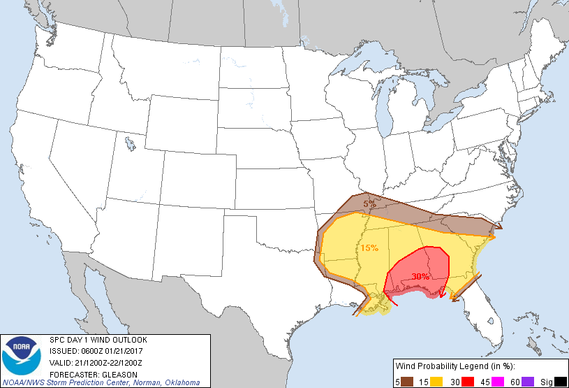
Probabilistic Damaging Wind Graphic
Probability of damaging thunderstorm winds or wind gusts of 50 knots or higher within 25 miles of a point. Hatched Area: 10% of greater probability of wind gusts 65 knots or greater within 25 miles of a point.
SPC AC 210600
Day 1 Convective Outlook
NWS Storm Prediction Center Norman OK
1200 AM CST Sat Jan 21 2017
Valid 211200Z - 221200Z
...THERE IS AN ENHANCED RISK OF SEVERE THUNDERSTORMS ACROSS PARTS OF
THE CENTRAL GULF COAST STATES AND FL PANHANDLE...
...THERE IS AN ENHANCED RISK OF SEVERE THUNDERSTORMS ACROSS PARTS OF
THE LOWER MS VALLEY AND MID-SOUTH...
...THERE IS A SLIGHT RISK OF SEVERE THUNDERSTORMS ACROSS MUCH OF THE
LOWER MS VALLEY AND SOUTHEAST...
...THERE IS A MARGINAL RISK OF SEVERE THUNDERSTORMS SURROUNDING THE
SLIGHT RISK...
...SUMMARY...
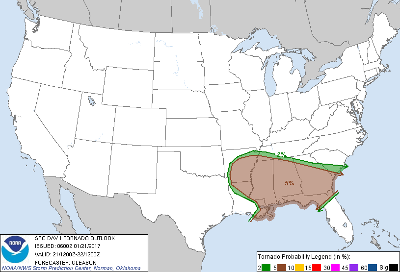
Multiple rounds of severe thunderstorms are expected across parts of
the lower Mississippi Valley through much of the eastern Gulf Coast
States beginning Saturday morning and continuing through early
Sunday morning. This includes the risk for a few tornadoes,
damaging wind gusts, and large hail.
...Synopsis...
A lead shortwave trough over the MS/TN Valleys Saturday morning will
move quickly northeastward to the Mid-Atlantic by Saturday evening.
Another mid-level trough with a 120+ kt jet streak will advance
eastward from the southwestern CONUS and northern Mexico to the
vicinity of the lower MS Valley by early Sunday morning. This trough
will likely form a closed low near the Ark-La-Tex late in the period
as the mid-level jet core moves over LA/MS/AL.
A low-level jet initially over southeastern LA/MS and southwestern
AL should shift eastward across AL/GA and the FL Panhandle through
Saturday afternoon before weakening. Re-intensification of the
low-level jet will likely occur Saturday evening into early Sunday
morning across much of southern and central AL/GA, as well as
northern FL.
At the surface, lee cyclogenesis across the southern High Plains
will occur in advance of the southwestern CONUS mid-level trough.
This surface low and attendant cold front is forecast to develop
eastward across the southern Plains through the end of the period. A
separate surface meso-low may form AR/LA by Saturday evening, moving
northeastward into the mid MS Valley with time. A moist low-level
airmass will remain across much of the lower MS Valley and
Southeast, supporting surface-based convection capable of all severe
hazards.
...Lower MS Valley through the Southeast...
Multiple rounds of severe weather are anticipated across this region
from 12Z Saturday morning through 12Z Sunday morning (end of Day 1
period). Each round, with its associated risks and uncertainties,
will be discussed separately below.
Round 1 (Saturday morning and afternoon): A line of thunderstorms
capable of producing strong to damaging winds and perhaps a tornado
or two will likely be ongoing at the beginning of the period (12Z)
across southeastern LA/MS into southwestern AL and perhaps the
western FL Panhandle. This line should move eastward through the
morning and early afternoon hours as an initial southwesterly
low-level jet advances eastward as well while slowly weakening. Low
to mid 60s surface dewpoints, modest diurnal heating downstream of
the convective line, strong effective bulk shear, and enlarged
low-level hodographs will likely support the continuation of a
damaging wind and tornado threat through Saturday afternoon.
Although instability should decrease with eastward extent, these
threats may extend to the SC/GA and northern FL Atlantic Coast, and
wind/tornado probabilities have been expanded eastward accordingly.
Confidence in this scenario is reasonably high given current
observational/radar trends, and general consensus amongst the
majority of convection-allowing model guidance.
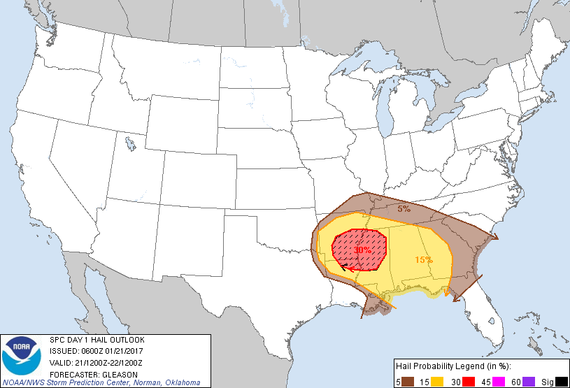
Round 2 (Saturday afternoon and evening, possibly continuing
overnight): With the approach of the southwestern CONUS upper trough
and strong mid-level jet, convection should develop by late Saturday
afternoon into early Saturday evening across AR and northern LA.
Steep mid-level lapse rates would favor large hail with initial
discrete development (some larger than 2 inches in diameter) and
with time a line of storms may develop across parts of the
Mid-South. Although this is far from certain, if linear
consolidation occurs, then damaging winds could become the main
threat into eastern MS, western AL, and perhaps southwestern TN. In
addition, a tornado or two may also be possible given low-level
winds veering with height that are expected to strengthen through
the evening, although surface dewpoints may struggle to reach much
above the low 60s. Overall, confidence in thunderstorms developing
across this region is relatively high, but the exact placement,
timing, and convective mode are much less clear.
Round 3 (Saturday night into early Sunday morning): In the wake of
earlier convection, airmass recovery with southerly surface winds
and a strengthening southwesterly low-level jet may allow for
renewed thunderstorm development Saturday night into early Sunday
morning across parts of southern AL into the FL Panhandle and
western GA. NAM forecast soundings across this region would support
the potential for all severe hazards with these thunderstorms if
they develop. Confidence in the details of this scenario are low.
..Gleason/Picca.. 01/21/2017
CLICK TO GET WUUS01 PTSDY1 PRODUCT
NOTE: THE NEXT DAY 1 OUTLOOK IS SCHEDULED BY 1300Z