Probability of damaging thunderstorm winds or wind gusts of 50 knots or higher within 25 miles of a point. Hatched Area: 10% of greater probability of wind gusts 65 knots or greater within 25 miles of a point.
New Orleans, LA...Atlanta, GA...Fort Wayne, IN...Akron, OH...Columbus, GA...
SPC AC 070551
Day 1 Convective Outlook
NWS Storm Prediction Center Norman OK
1151 PM CST Mon Feb 06 2017
Valid 071200Z - 081200Z
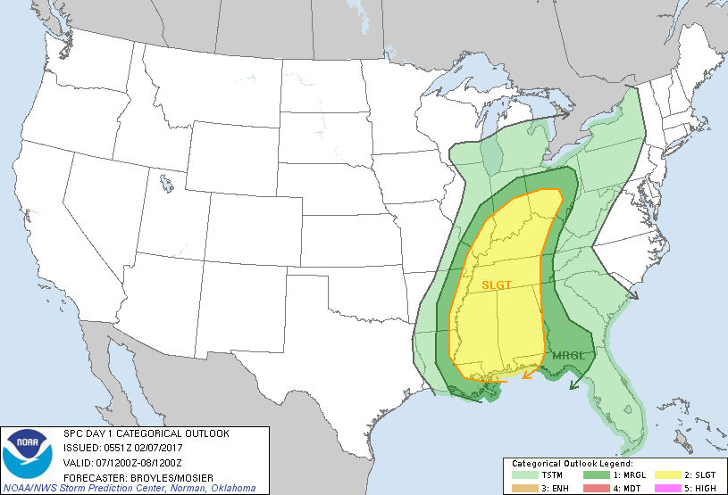
...THERE IS A SLIGHT RISK OF SEVERE THUNDERSTORMS ACROSS PARTS OF
THE LOWER MISSISSIPPI VALLEY AND CENTRAL GULF COAST STATES...
...THERE IS A MARGINAL RISK OF SEVERE THUNDERSTORMS ACROSS PARTS OF
THE OHIO AND TENNESSEE VALLEYS...
...SUMMARY...
Scattered thunderstorms with some severe are forecast to affect the
lower to mid Mississippi Valley and central Gulf Coast States
extending northward into the Ohio and Tennessee Valleys today.
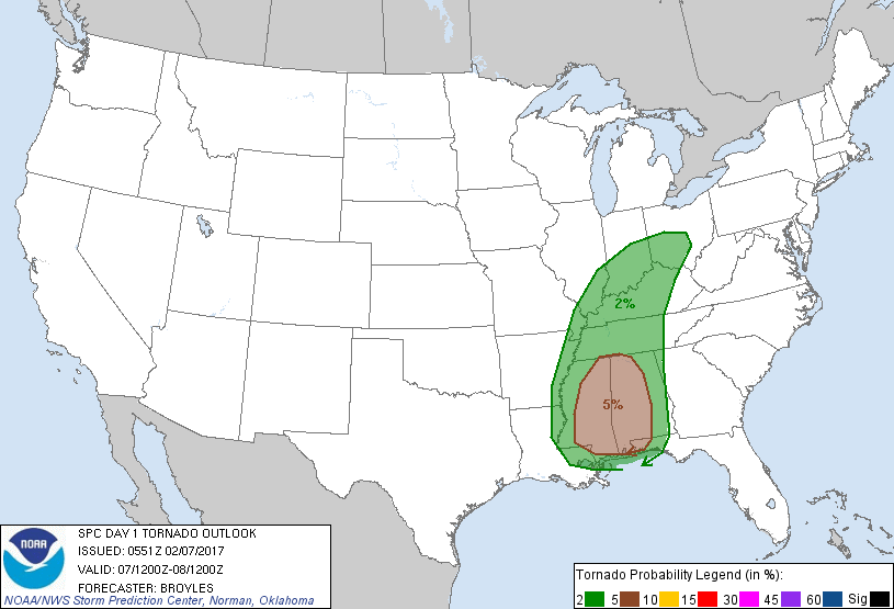
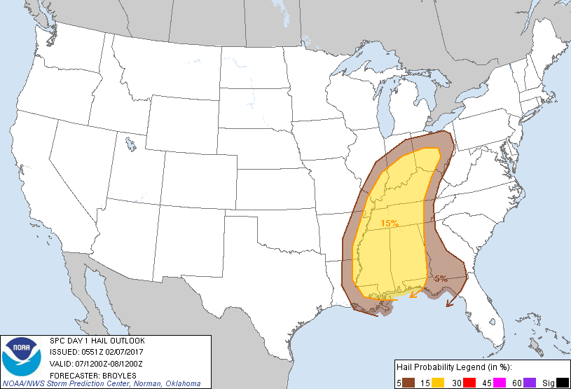
Isolated large hail, wind damage and a tornado threat is expected to
accompany the strongest thunderstorm clusters.
...Lower Mississippi Valley/Central Gulf Coast States...
A shortwave trough will move eastward from the southern and central
Plains into the lower to mid Mississippi Valley today. Ahead of the
shortwave trough, an axis of moderate instability will be in place
from east Texas and Louisiana northward across Arkansas. Scattered
strong thunderstorms are likely be ongoing at 12Z this morning just
to the east of the strongest instability from near Little Rock
eastward toward the Mississippi River. Other strong thunderstorms
may be ongoing in north central Louisiana. An isolated severe threat
is likely to accompany this convection as it moves eastward into the
central Gulf Coast States this morning. By midday, a large area of
thunderstorms is forecast to be ongoing across much of Mississippi
with this activity spreading eastward into Alabama by this
afternoon.
RAP forecast soundings at 18Z for Jackson and Hattiesburg,
Mississippi show MLCAPE near 1500 J/kg, 0-6 km shear of 30 to 40 kt,
700-500 mb lapse rates of 7.5 C/km and 0-3 km storm relative
helicities of 250 to 300 m2/s2. This environment will likely support
supercells and/or bowing line segments with a potential for large
hail, wind damage and a tornado threat. The current thinking is that
the severe threat will gradually ramp up during the morning
maximizing around midday in eastern Mississippi and western Alabama.
The tornado threat is forecast to be greatest in southeastern
Mississippi and southwestern Alabama where the combination of
low-level shear and instability is forecast to be maximized. A more
widespread severe threat will be possible in this area but a couple
caveats introduce uncertainty into the forecast. Those factors
include deep-layer shear that is forecast to remain near the
lowest-end for supercells and convection that is forecast to be
located well to the east of the strongest instability.
...Ohio and Tennessee Valleys...
A shortwave trough will move eastward across the middle Mississippi
Valley into the Ohio Valley today. At the surface, a low will deepen
and move northeastward in the Great Lakes region as a cold front
advances eastward across the mid Mississippi Valley. Scattered
thunderstorms will likely be ongoing from near the surface low
extending southward into the lower Ohio Valley. This activity is
forecast to spread from southern Indiana and western Kentucky
eastward into Ohio and central Kentucky during the late morning and
early afternoon. RAP forecast soundings along this corridor at 18Z
to 21Z suggest instability will remain weak with MLCAPE values
peaking in the 500 to 1000 J/Kg range. In addition, forecast
soundings show moderate deep-layer shear profiles with 0-6 km shear
generally in the 40 to 50 Kt range. This may be enough for storm
rotation with the stronger thunderstorms. Isolated large hail,
strong wind gusts and a marginal tornado threat would be possible
with any cells that can exhibit rotation.
..Broyles/Mosier.. 02/07/2017
CLICK TO GET WUUS01 PTSDY1 PRODUCT
NOTE: THE NEXT DAY 1 OUTLOOK IS SCHEDULED BY 1300Z