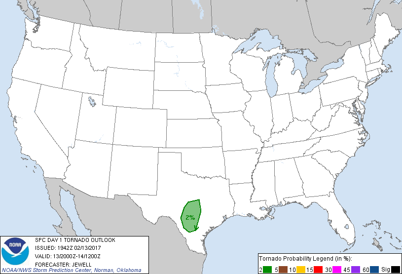
San Antonio, TX...Austin, TX...San Angelo, TX...Cedar Park, TX...San Marcos, TX...
Probabilistic Tornado Graphic
Probability of a tornado within 25 miles of a point. Hatched Area: 10% or greater probability of EF2 - EF5 tornadoes within 25 miles of a point.
Day 1 Tornado Risk
Area (sq. mi.)
Area Pop.
Some Larger Population Centers in Risk Area
2 %
23,667
3,855,452
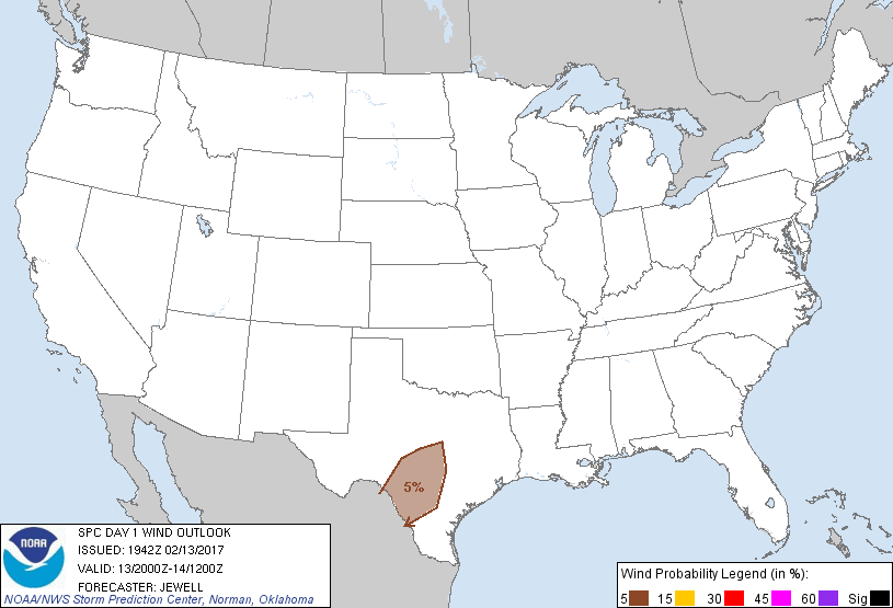
San Antonio, TX...Austin, TX...Round Rock, TX...Cedar Park, TX...San Marcos, TX...
Probabilistic Damaging Wind Graphic
Probability of damaging thunderstorm winds or wind gusts of 50 knots or higher within 25 miles of a point. Hatched Area: 10% of greater probability of wind gusts 65 knots or greater within 25 miles of a point.
Day 1 Wind Risk
Area (sq. mi.)
Area Pop.
Some Larger Population Centers in Risk Area
5 %
34,058
3,759,109
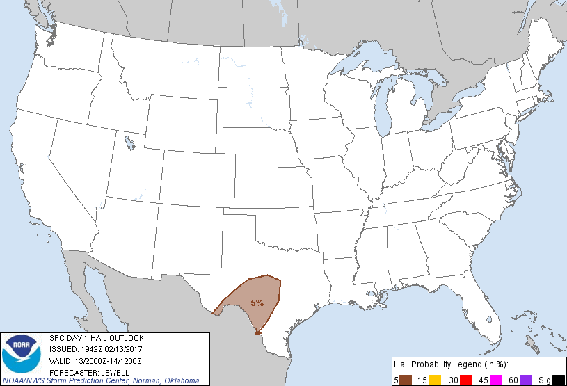
San Antonio, TX...Austin, TX...Cedar Park, TX...San Marcos, TX...New Braunfels, TX...
Probabilistic Large Hail Graphic
Probability of hail 1" or larger within 25 miles of a point. Hatched Area: 10% or greater probability of hail 2" or larger within 25 miles of a point.
Day 1 Hail Risk
Area (sq. mi.)
Area Pop.
Some Larger Population Centers in Risk Area
5 %
48,156
1,676,247
San Angelo, TX...Del Rio, TX...Kerrville, TX...Canyon Lake, TX...Brownwood, TX...
SPC AC 131942
Day 1 Convective Outlook RESENT 1
NWS Storm Prediction Center Norman OK
0142 PM CST Mon Feb 13 2017
Valid 132000Z - 141200Z
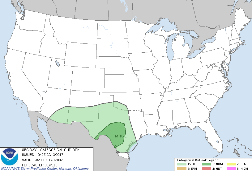
...THERE IS A MARGINAL RISK OF SEVERE THUNDERSTORMS ACROSS PARTS OF
CENTRAL TEXAS INTO THE MIDDLE RIO GRANDE VALLEY....
...SUMMARY...
Scattered thunderstorms and isolated severe weather are possible
this evening and overnight in parts of the Edwards Plateau, nearby
Hill Country and Rio Grande Valley, and south-central Texas.
No changes were necessary to the previous outlook.
..Jewell.. 02/13/2017
.PREV DISCUSSION... /ISSUED 1031 AM CST Mon Feb 13 2017/
...Synopsis...
A mid-level low along the AZ/NM/international border region will be
the primary impetus for the severe weather threat across Texas.
This low will move steadily eastward through the forecast period
while evolving into an open wave. 50-60 knot southwesterly flow
aloft will develop immediately downstream of this feature and spread
across much of the southern Plains today. At the surface, a warm
front currently analyzed from near VCT to near COT will migrate
further inland across southern and central Texas, spreading low 60s
dewpoints inland across central Texas this evening. A weak surface
low will develop near the Rio Grande River Valley, while surface
ridging will remain intact across west Texas and Eastern New Mexico.
...Southern and Central Texas...
Mostly elevated convection persists this morning in west Texas
southward to near DRT. Continued warm advection atop the
aforementioned surface ridge will foster areas of 500-1000 J/kg
MUCAPE rooted above 850mb particularly across south-central Texas.
This instability, combined with cooling mid-level temps (in
association with the approaching mid-level low) and associated
forcing for ascent will result in a few instances of hail
approaching severe limits.
Farther east, continued low-level warm advection will increase
tonight in conjunction with a 35-45 kt southerly low-level jet.
Capping will be weak today, and low to mid 60s dewpoints will foster
some surface-based instability. A conditional threat of surface
based convection will exist from early-mid afternoon through the end
of the forecast period, with weak to moderate instability and shear
profiles supportive of updraft rotation in any isolated convection
that can develop. Marginal hail/wind probabilities have been
maintained to address this threat, and marginal tornado
probabilities have also been added to this outlook.
Overnight, models suggest potential for a linear convective complex
across central Texas. Weak instability will be a primary limiting
factor for a more appreciable severe weather threat, but supercell
wind shear profiles and near-surface based convection will continue
to support a marginal risk of wind gusts and perhaps a tornado
through the end of the forecast period.
CLICK TO GET WUUS01 PTSDY1 PRODUCT
NOTE: THE NEXT DAY 1 OUTLOOK IS SCHEDULED BY 0100Z