San Antonio, TX...Fort Worth, TX...Killeen, TX...Wichita Falls, TX...Cedar Park, TX...
MARGINAL
116,863
16,880,216
Dallas, TX...Austin, TX...Oklahoma City, OK...Arlington, TX...Corpus Christi, TX...
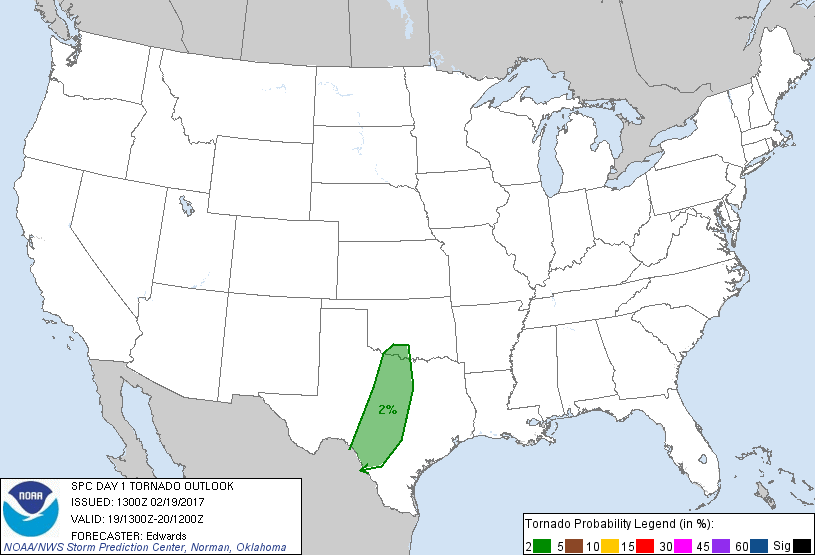
Probabilistic Tornado Graphic
Probability of a tornado within 25 miles of a point. Hatched Area: 10% or greater probability of EF2 - EF5 tornadoes within 25 miles of a point.
Day 1 Tornado Risk
Area (sq. mi.)
Area Pop.
Some Larger Population Centers in Risk Area
2 %
58,137
4,833,780
San Antonio, TX...Fort Worth, TX...Killeen, TX...Wichita Falls, TX...Lawton, OK...
Probabilistic Damaging Wind Graphic
Probability of damaging thunderstorm winds or wind gusts of 50 knots or higher within 25 miles of a point. Hatched Area: 10% of greater probability of wind gusts 65 knots or greater within 25 miles of a point.
Day 1 Wind Risk
Area (sq. mi.)
Area Pop.
Some Larger Population Centers in Risk Area
15 %
32,450
3,941,132
San Antonio, TX...Fort Worth, TX...Killeen, TX...Cedar Park, TX...New Braunfels, TX...
5 %
139,060
17,626,138
Houston, TX...Dallas, TX...Austin, TX...Oklahoma City, OK...Arlington, TX...
Probabilistic Large Hail Graphic
Probability of hail 1" or larger within 25 miles of a point. Hatched Area: 10% or greater probability of hail 2" or larger within 25 miles of a point.
Day 1 Hail Risk
Area (sq. mi.)
Area Pop.
Some Larger Population Centers in Risk Area
15 %
55,013
4,414,573
San Antonio, TX...Abilene, TX...Killeen, TX...Wichita Falls, TX...Cedar Park, TX...
5 %
116,087
16,790,612
Dallas, TX...Austin, TX...Fort Worth, TX...Oklahoma City, OK...Arlington, TX...
SPC AC 191300
Day 1 Convective Outlook
NWS Storm Prediction Center Norman OK
0700 AM CST Sun Feb 19 2017
Valid 191300Z - 201200Z
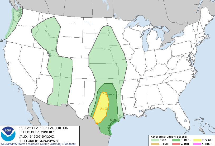
...THERE IS A SLIGHT RISK OF SEVERE THUNDERSTORMS FROM THE RED RIVER
REGION OF NORTHWEST TX AND SOUTHWEST OK...ACROSS THE HILL
COUNTRY...TO THE RIO GRANDE SOUTHWEST OF SAN ANTONIO....
...THERE IS A MARGINAL RISK OF SEVERE THUNDERSTORMS ELSEWHERE FROM
CENTRAL OK TO DEEP SOUTH TX...
...SUMMARY...
Severe thunderstorms are possible across parts of the southern
Plains late today and this evening, developing farther southward
across the Hill Country and perhaps into much of south Texas
tonight. Large hail and sporadic wind damage are possible, and a
tornado or two cannot be ruled out.
...Synopsis...
In mid/upper levels, a highly amplified yet progressive pattern will
remain in place through the period. The well-defined trough now
extending from the central Appalachians region to the northeastern
Gulf is forecast to dig east-southeastward across the Atlantic just
north of the Bahamas. Meanwhile, in its wake, synoptic ridging will
move eastward across the Mississippi Valley to the upper Great
Lakes, Tennessee Valley, Florida Panhandle, and eastern Gulf.
Upstream, phased troughing is evident in northern and southern
streams, with the combined trough now apparent in moisture-channel
imagery from offshore of the Pacific Northwest southeastward across
NV and AZ, then southward across southern Baja to tropical latitudes
of the East Pacific. As additional shortwaves (now well out over
the North Pacific) reinforce larger-scale troughing off the West
Coast, the inland trough will elongate meridionally and its
vorticity pattern will split. By the end of the period, what now is
an embedded mid/upper low over northern AZ should eject
northeastward across the central Rockies as an open wave, reaching
the central High Plains by 12Z, and still in phase with a
northern-stream extension across MT to eastern AB. The remainder of
the trough over AZ and the Pacific will proceed eastward, reaching
the southern High Plains, Big Bend region of TX, and west-central MX
by 12Z.
At the surface, lee troughing (with several weak/attached lows) is
already well-established from central MT southeastward to eastern Co
then south-southeastward across eastern NM. Cyclogenesis is
expected this evening over the NE Panhandle or Badlands SD region,
with the resultant low reaching eastern ND by 12Z. The surface
trough to its south will move eastward across the High Plains to a
position near a JMS-HSI-P28-LRD line by the end of the period. A
cold front extending south-southwestward from the Dakotas low will
overtake the trough from north to south during the late
overnight/early morning hours. A dryline, analyzed at 11Z from
south of MAF into northern Coahuila, will become better-defined from
south to north today across west TX and the eastern Panhandles as
moisture return continues in the warm sector to its east.
...Southern Plains...
At least two primary rounds of convection will contribute to severe
potential across the outlook area this period. The slight-risk
probabilities have been expanded in deference to increasing coverage
and severe potential mainly with the second:
1. Isolated to widely scattered thunderstorms may develop gradually
this afternoon -- as early as about 20Z -- in a low-level
confluence/convergence zone located east of the dryline/lee trough,
in central to northwest TX. This activity should move northward to
north-northeastward over the rest of northwest and western
north-central TX and into OK while increasing in coverage. An
initially well-defined capping layer at the EML base -- evident in
12Z soundings -- should erode gradually amidst a combination of
low-level thetae advection and cooling aloft. This in tandem with
surface heating should foster convective development and gradual
deepening starting in mid/late afternoon, as low-mid 60s F surface
dew points now over central/south TX, and associated PW near an
inch, spread northward in the return flow. MLCAPE around 1000-1500
J/kg should cover most of the area by late afternoon.
In forecast soundings, lack of stronger flow around 800-900 mb
limits hodograph size and SRH over much of north TX and southern OK
where surface-based effective-inflow parcels are apparent. Still,
favorable deep-layer speed/bulk shear will support supercell
potential, as will stronger low-level shear just along the
northeastern fringes of the surface-based warm sector. Any
sustained cells developing/growing in the warm sector may become
surface-based and mature atop at least a weakly buoyant boundary
layer before outpacing that destabilization and crossing into cooler
air. As such, marginal tornado probabilities are being introduced,
subject to additional increase in later outlooks if mesoscale
developments warrant. Some models' more-aggressive destabilization
trends into OK are dependent on lack of convective/cloud cover,
related stronger heating and faster return-flow moistening than
currently expected. Any such mesoscale trends may compel later
northward extension of probabilities as well.
2. Thunderstorms should develop this evening into tonight in a
south/north-oriented corridor ahead of the dryline, between central
Texas and the Rio Grande Valley, amidst increasing low-level
convergence and large-scale forcing for ascent. Until this activity
aggregates into a band, a few supercells are possible. Moist
advection back into parts of south-central TX during the evening
should overcome pockets of diurnally mixing-reduced moisture in
support of nocturnal convective potential. With time overnight,
amidst deep meridional flow and an increasingly pronounced
veer-back-veer wind pattern with height, convective modes generally
should become more messy and quasi-linear in character. In concert
with that, hail potential ramps down, and wind-damage and brief/
conditional tornado potential exist in the form of embedded
supercells and QLCS-generated vortices. With eastward extent across
much of eastern OK and east TX, convection generally will encounter
a less-favorable vertical thermodynamic profile late tonight, and
severe potential generally should become more marginal.
..Edwards/Peters.. 02/19/2017
CLICK TO GET WUUS01 PTSDY1 PRODUCT
NOTE: THE NEXT DAY 1 OUTLOOK IS SCHEDULED BY 1630Z