Probability of a tornado within 25 miles of a point. Hatched Area: 10% or greater probability of EF2 - EF5 tornadoes within 25 miles of a point.
Day 1 Tornado Risk
Area (sq. mi.)
Area Pop.
Some Larger Population Centers in Risk Area
No Risk Areas Forecast
Probabilistic Damaging Wind Graphic
Probability of damaging thunderstorm winds or wind gusts of 50 knots or higher within 25 miles of a point. Hatched Area: 10% of greater probability of wind gusts 65 knots or greater within 25 miles of a point.
Day 1 Wind Risk
Area (sq. mi.)
Area Pop.
Some Larger Population Centers in Risk Area
No Risk Areas Forecast
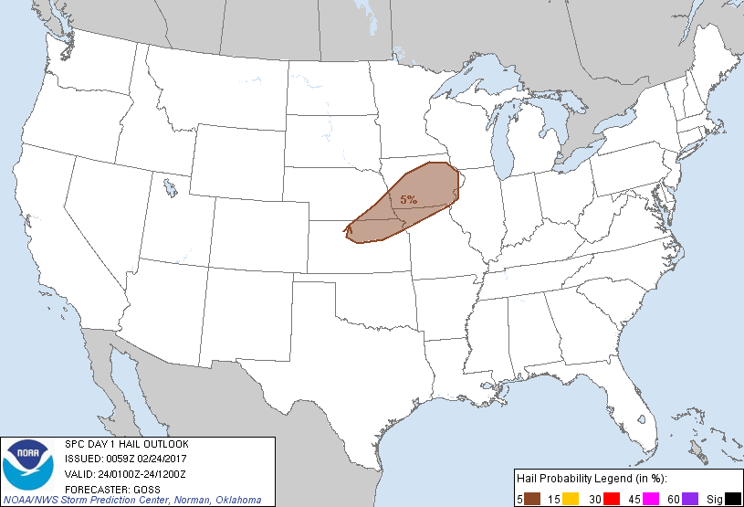
Probabilistic Large Hail Graphic
Probability of hail 1" or larger within 25 miles of a point. Hatched Area: 10% or greater probability of hail 2" or larger within 25 miles of a point.
   SPC AC 240059

   Day 1 Convective Outlook
   NWS Storm Prediction Center Norman OK
   0659 PM CST Thu Feb 23 2017

   Valid 240100Z - 241200Z

   ...THERE IS A MARGINAL RISK OF SEVERE THUNDERSTORMS FROM NORTHEAST
   KANSAS AND SOUTHEAST NEBRASKA INTO IOWA AND NORTHERN MISSOURI...

   ...SUMMARY...
   Showers and thunderstorms -- a few of which may produce hail that
   approaches or even reaches marginal severe levels -- are expected
   from northeast Kansas and southeast Nebraska northeastward across
   parts of northern Missouri and Iowa this evening and overnight.

   ...Synopsis...
   Mid-level troughing will continue to shift gradually eastward across
   the central Plains this evening/overnight, while an associated
   surface low now over southwest Kansas moves east-northeast, reaching
   the northeast Missouri/west-central Illinois vicinity by the end of
   the period.  A warm front extending east from the low will gradually
   shift northward across the Midwest, while a trailing cold front
   advances southeastward across the southern Plains overnight.

   ...Parts of northern Kansas and southeast Nebraska northeast across
   Iowa and northern Missouri...
   Latest radar loop shows widespread rain/rain showers from Nebraska
   eastward into the upper Great Lakes region, with scattered/elevated
   thunderstorms developing on the southern fringe of this area of
   precipitation -- i.e. from north central Kansas and parts of
   southeast Nebraska into Iowa.  The convection is occurring in a zone
   of strong quasi-geostrophic forcing for ascent ahead of the
   advancing upper system and north of the surface warm front, where
   several hundred J/kg elevated CAPE exists per model forecast
   soundings and extrapolation of evening RAOBs.

   Given the degree of elevated CAPE, in conjunction with strong
   southwesterly flow at mid levels supporting favorable cloud-layer
   shear, a few stronger storms will likely evolve from time to time
   this evening and into the overnight hours.  Small hail -- possibly
   nearing or exceeding severe levels with a couple of the strongest
   updrafts -- can be expected, with the risk area shifting
   northeastward with time across the mid-Missouri valley area.

   ...Elsewhere...
   Showers and a few thunderstorms are forecast to persist across parts
   of Ohio and Pennsylvania, and later into New York state.  Weak
   instability precludes any appreciable severe risk.

   ..Goss.. 02/24/2017

   CLICK TO GET WUUS01 PTSDY1 PRODUCT

   NOTE: THE NEXT DAY 1 OUTLOOK IS SCHEDULED BY 0600Z