Kansas City, MO...Tulsa, OK...St. Louis, MO...Overland Park, KS...Springfield, MO...
SLIGHT
130,393
7,869,246
Des Moines, IA...Little Rock, AR...Cedar Rapids, IA...Springfield, IL...Peoria, IL...
MARGINAL
107,767
17,522,562
Chicago, IL...Memphis, TN...Oklahoma City, OK...Madison, WI...Aurora, IL...
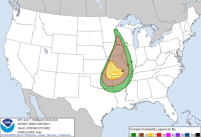
Probabilistic Tornado Graphic
Probability of a tornado within 25 miles of a point. Hatched Area: 10% or greater probability of EF2 - EF5 tornadoes within 25 miles of a point.
Day 1 Tornado Risk
Area (sq. mi.)
Area Pop.
Some Larger Population Centers in Risk Area
SIG SEVERE
45,006
4,343,601
Kansas City, MO...Overland Park, KS...Springfield, MO...Kansas City, KS...Olathe, KS...
10 %
45,810
4,606,619
Kansas City, MO...Tulsa, OK...Overland Park, KS...Springfield, MO...Kansas City, KS...
5 %
122,695
8,633,531
St. Louis, MO...Des Moines, IA...Cedar Rapids, IA...Davenport, IA...Rochester, MN...
2 %
92,481
6,805,831
Memphis, TN...Oklahoma City, OK...Little Rock, AR...Topeka, KS...Springfield, IL...
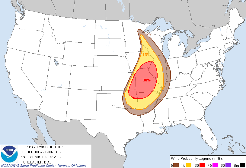
Probabilistic Damaging Wind Graphic
Probability of damaging thunderstorm winds or wind gusts of 50 knots or higher within 25 miles of a point. Hatched Area: 10% of greater probability of wind gusts 65 knots or greater within 25 miles of a point.
Day 1 Wind Risk
Area (sq. mi.)
Area Pop.
Some Larger Population Centers in Risk Area
30 %
105,605
9,749,718
Kansas City, MO...Tulsa, OK...St. Louis, MO...Overland Park, KS...Springfield, MO...
15 %
130,475
7,928,456
Des Moines, IA...Little Rock, AR...Cedar Rapids, IA...Springfield, IL...Peoria, IL...
5 %
108,440
17,853,247
Chicago, IL...Memphis, TN...Oklahoma City, OK...Madison, WI...Aurora, IL...
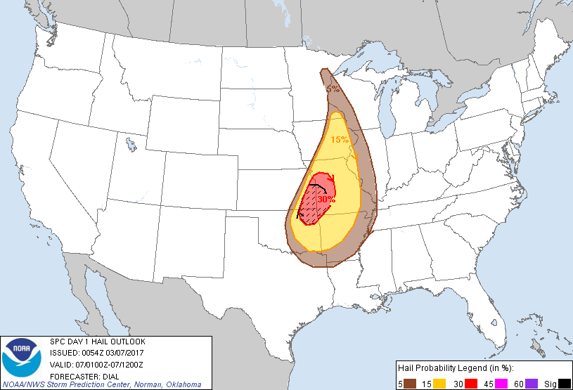
Probabilistic Large Hail Graphic
Probability of hail 1" or larger within 25 miles of a point. Hatched Area: 10% or greater probability of hail 2" or larger within 25 miles of a point.
Kansas City, MO...Tulsa, OK...Overland Park, KS...Kansas City, KS...Olathe, KS...
15 %
126,971
7,702,700
Des Moines, IA...Little Rock, AR...Springfield, MO...Cedar Rapids, IA...Columbia, MO...
5 %
113,659
8,820,445
Memphis, TN...Oklahoma City, OK...St. Louis, MO...Topeka, KS...Springfield, IL...
SPC AC 070054
Day 1 Convective Outlook
NWS Storm Prediction Center Norman OK
0654 PM CST Mon Mar 06 2017
Valid 070100Z - 071200Z
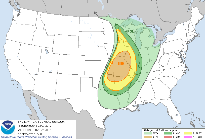
...THERE IS AN ENHANCED RISK OF SEVERE THUNDERSTORMS FROM EASTERN
PORTIONS OF KANSAS AND OKLAHOMA INTO THE MIDDLE MISSISSIPPI VALLEY
REGION...
...THERE IS A SLIGHT RISK OF SEVERE THUNDERSTORMS FROM EASTERN
KANSAS AND OKLAHOMA THROUGH A PORTION OF THE LOWER THROUGH UPPER
MISSISSIPPI VALLEY...
...THERE IS A MARGINAL RISK OF SEVERE THUNDERSTORMS FROM EASTERN
KANSAS AND OKLAHOMA THROUGH A LARGE PART OF THE MISSISSIPPI
VALLEY...
...SUMMARY...
Severe storms are expected until mid evening over the upper
Mississippi Valley area. Other severe storms will persist into the
overnight across the middle to lower Mississippi Valley region and a
portion of eastern Kansas into Oklahoma. Damaging wind, large hail
and a few tornadoes are expected, but the dominant threat should
transition to damaging wind later tonight.
...Eastern Kansas and Oklahoma into the Mississippi Valley region...
Squall line currently western WI through IA into northeast KS will
continue to pose a threat for severe weather as it continues east
tonight including large hail, damaging wind and a few tornadoes.
Instability corridor is narrow over the upper MS Valley region, and
storms will likely weaken toward mid evening as they move farther
into WI.
Farther south, the severe threat will likely persist into the
overnight and early morning. Storms should continue to backbuild
along southeastward-advancing cold front through the remainder of
eastern KS into eastern OK. A strong mid-level jet rotating through
the base of a northeastward-ejecting upper trough coupled with an
intensifying southwesterly low-level jet is contributing to very
favorable vertical shear profiles and large 0-1 km hodographs
supportive of organized storms. Embedded supercell and bowing
structures are likely as the line develops through eastern Kansas
and Oklahoma and eventually into MO and AR, and this activity will
pose a threat for mainly damaging wind and large hail, with a few
tornadoes also possible. Additional more discrete storms may develop
within the low-level confluent flow regime across northern AR into
MO this evening. Some of these storms may evolve into supercells
with a threat for large hail and a few tornadoes.
..Dial.. 03/07/2017
CLICK TO GET WUUS01 PTSDY1 PRODUCT
NOTE: THE NEXT DAY 1 OUTLOOK IS SCHEDULED BY 0600Z