Probability of a tornado within 25 miles of a point. Hatched Area: 10% or greater probability of EF2 - EF5 tornadoes within 25 miles of a point.
Day 1 Tornado Risk
Area (sq. mi.)
Area Pop.
Some Larger Population Centers in Risk Area
No Risk Areas Forecast
Probabilistic Damaging Wind Graphic
Probability of damaging thunderstorm winds or wind gusts of 50 knots or higher within 25 miles of a point. Hatched Area: 10% of greater probability of wind gusts 65 knots or greater within 25 miles of a point.
Day 1 Wind Risk
Area (sq. mi.)
Area Pop.
Some Larger Population Centers in Risk Area
No Risk Areas Forecast
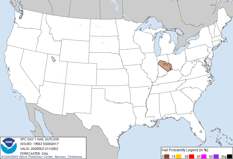
Probabilistic Large Hail Graphic
Probability of hail 1" or larger within 25 miles of a point. Hatched Area: 10% or greater probability of hail 2" or larger within 25 miles of a point.
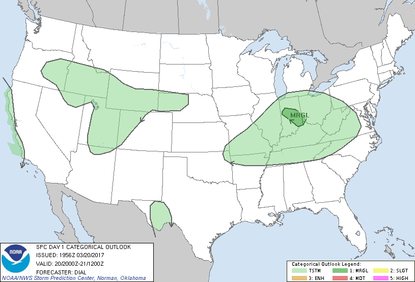
   SPC AC 201956

   Day 1 Convective Outlook
   NWS Storm Prediction Center Norman OK
   0256 PM CDT Mon Mar 20 2017

   Valid 202000Z - 211200Z

   ...THERE IS A MARGINAL RISK OF SEVERE THUNDERSTORMS FROM CENTRAL
   INDIANA INTO SOUTHWEST OHIO...

   ...SUMMARY...
   Scattered thunderstorms capable of isolated hail will persist
   through a portion of the Ohio Valley this afternoon.

   ...Ohio Valley area...

   Cluster of storms over IN into southwest OH that are developing
   within a warm advection regime will continue southeast this
   afternoon. Strongest storms with a risk for hail will remain on the
   southwest flank of the MCS where inflow of unstable air is
   maximized. Threat is expected to diminish by early evening, and due
   to the very isolated nature of the severe risk, will maintain
   marginal category this update.

   ..Dial.. 03/20/2017

   .PREV DISCUSSION... /ISSUED 1111 AM CDT Mon Mar 20 2017/

   ...IL/IN/OH...
   A rather large MCS has affected much of IN this morning.  This
   system is tracking southeastward and away from the region, allowing
   the air mass in its wake to destabilize and recover.  Rather steep
   mid level lapse rates are forecast to re-develop across the area,
   with scattered showers and thunderstorms currently forming over
   northeast IL tracking across the area.  Forecast soundings suggest
   sufficient elevated CAPE and other parameters to favor hail in the
   stronger cores as they move southeastward across much of IN, and
   into southwest OH early this evening.

   ...MO/southern IL...
   A favorable thermodynamic environment for hail exists farther
   southwest into parts of southern IL and southern MO today.  Latest
   visible satellite imagery shows increasing ACCAS in this region,
   suggesting some potential for mid-level convective development.
   Also, 12z CAM solutions indicate some low potential for an isolated
   thunderstorm or two.  If this activity develops, hail would be
   possible.  Given the limited risk of initiation, will not include
   severe probabilities at this time.

   ...southern ID...
   Water vapor loops show a weak shortwave trough moving northeastward
   across NV.  This feature will track into parts of ID later today,
   aiding in the development of scattered showers and isolated
   thunderstorms over the Snake River Valley.  Substantial cloud cover
   and limited moisture/instability suggest the risk will remain low.
   However, there is some chance of hail in the stronger cells this
   afternoon and evening.

   CLICK TO GET WUUS01 PTSDY1 PRODUCT

   NOTE: THE NEXT DAY 1 OUTLOOK IS SCHEDULED BY 0100Z