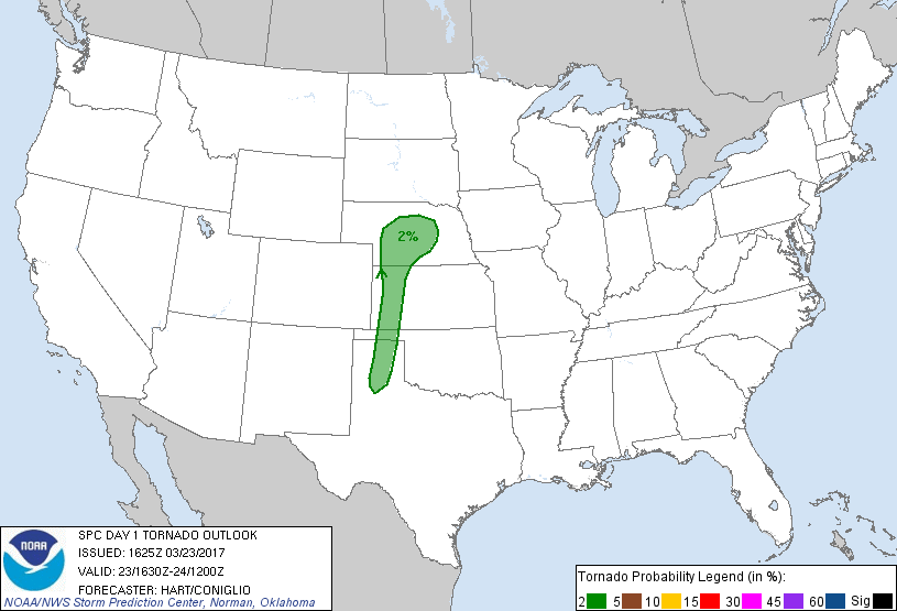
Probability of a tornado within 25 miles of a point. Hatched Area: 10% or greater probability of EF2 - EF5 tornadoes within 25 miles of a point.
Day 1 Tornado Risk
Area (sq. mi.)
Area Pop.
Some Larger Population Centers in Risk Area
2 %
51,674
661,881
Amarillo, TX...Grand Island, NE...Kearney, NE...Garden City, KS...North Platte, NE...
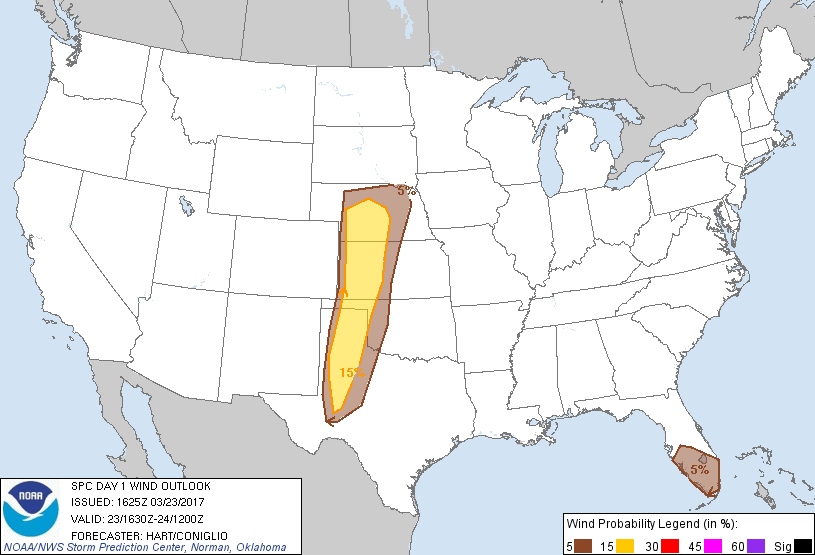
Probabilistic Damaging Wind Graphic
Probability of damaging thunderstorm winds or wind gusts of 50 knots or higher within 25 miles of a point. Hatched Area: 10% of greater probability of wind gusts 65 knots or greater within 25 miles of a point.
Day 1 Wind Risk
Area (sq. mi.)
Area Pop.
Some Larger Population Centers in Risk Area
15 %
88,342
1,389,626
Lubbock, TX...Amarillo, TX...Midland, TX...Kearney, NE...Garden City, KS...
SPC AC 231625
Day 1 Convective Outlook
NWS Storm Prediction Center Norman OK
1125 AM CDT Thu Mar 23 2017
Valid 231630Z - 241200Z
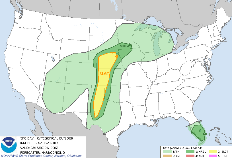
...THERE IS A SLIGHT RISK OF SEVERE THUNDERSTORMS THIS AFTERNOON AND
EVENING OVER PARTS OF THE HIGH PLAINS...
...THERE IS A MARGINAL RISK OF SEVERE THUNDERSTORMS FROM PARTS OF
MN/IA SOUTHWARD INTO TX...
...THERE IS A MARGINAL RISK OF SEVERE THUNDERSTORMS OVER CENTRAL AND
SOUTH FL...
...SUMMARY...
Strong to severe thunderstorms are expected from parts of the
central and southern Plains to the mid Missouri Valley late this
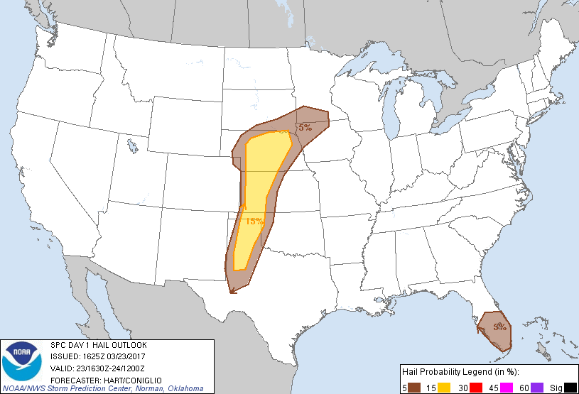
afternoon into tonight, offering hail and damaging gusts.
Thunderstorms with a marginal risk for severe wind and hail are also
possible today across parts of central and southern Florida.
A large upper trough is moving eastward across the western states
today. Upper-level height falls and associated large-scale forcing
for ascent will spread into the High Plains this afternoon, helping
to initiate scattered thunderstorms. Activity will likely form along
the dryline over western KS and the western TX Panhandle, but also
in a region of stronger low level warm advection and lift across
western and central NE. This scenario will result in a
several-hour-long period of risk of severe storms capable of large
hail and damaging winds in these areas.
...TX/KS...
The primary forecast problem today is the limited low-level moisture
and capping inversion in place. 12z models suggest that storms will
develop in the 4-6pm window as stronger forcing impinges on the
dryline. Forecast soundings suggest this activity will be mainly
high-based. This will promote strong downdraft winds and
occasionally intense updrafts capable of large hail. Present
indications are that storms will not progress very far eastward this
evening before beginning to weaken due to the onset of diurnal
cooling.
...Northwest KS/NE...
Forcing for convection will be more subtle over NE this afternoon
and evening. However, this area will be in proximity to the surface
warm front and weak cyclogenesis, where stronger low level vertical
shear is forecast. Storm mode will likely be more
discrete-supercell in this area, with the potential for an isolated
storm or two capable of very large hail or significant wind gusts.
Low-level moisture will be limited, which should preclude a more
substantial tornado threat.
...FL...
Few changes have been made to the Marginal risk for this region.
Strong daytime heating and sufficient CAPE will promote scattered
afternoon thunderstorms today. Relatively steep low and mid-level
lapse rates suggest that hail will be possible in the stronger
cells. The coverage of severe storms is expected to remain low, so
will maintain the Marginal categorical risk.
..Hart/Coniglio.. 03/23/2017
CLICK TO GET WUUS01 PTSDY1 PRODUCT
NOTE: THE NEXT DAY 1 OUTLOOK IS SCHEDULED BY 2000Z