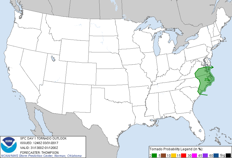
Probability of a tornado within 25 miles of a point. Hatched Area: 10% or greater probability of EF2 - EF5 tornadoes within 25 miles of a point.
Day 1 Tornado Risk
Area (sq. mi.)
Area Pop.
Some Larger Population Centers in Risk Area
2 %
44,800
6,027,955
Virginia Beach, VA...Norfolk, VA...Chesapeake, VA...Richmond, VA...Newport News, VA...
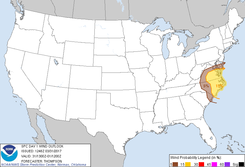
Probabilistic Damaging Wind Graphic
Probability of damaging thunderstorm winds or wind gusts of 50 knots or higher within 25 miles of a point. Hatched Area: 10% of greater probability of wind gusts 65 knots or greater within 25 miles of a point.
Day 1 Wind Risk
Area (sq. mi.)
Area Pop.
Some Larger Population Centers in Risk Area
15 %
45,720
5,798,311
Virginia Beach, VA...Norfolk, VA...Chesapeake, VA...Richmond, VA...Newport News, VA...
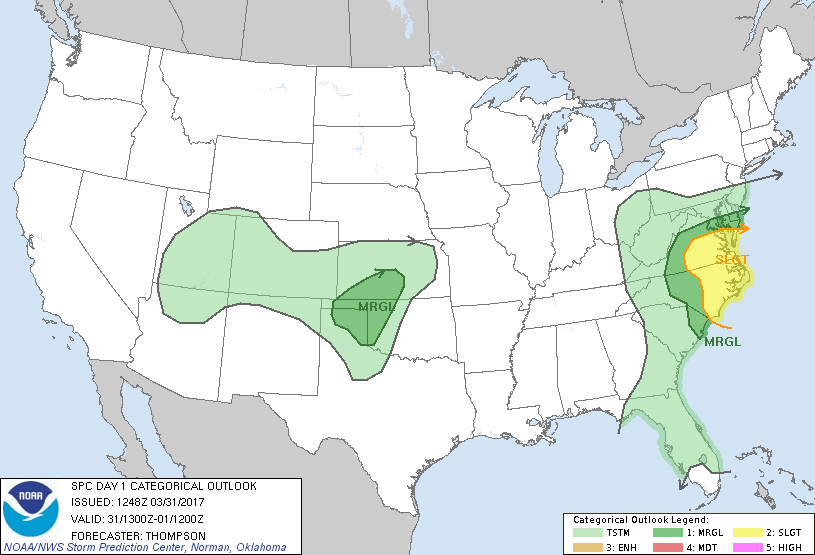
   SPC AC 311248

   Day 1 Convective Outlook
   NWS Storm Prediction Center Norman OK
   0748 AM CDT Fri Mar 31 2017

   Valid 311300Z - 011200Z

   ...THERE IS A SLIGHT RISK OF SEVERE THUNDERSTORMS TODAY FROM EASTERN
   NORTH CAROLINA INTO SOUTHEASTERN VIRGINIA...

   ...THERE IS A MARGINAL RISK OF SEVERE THUNDERSTORMS SURROUNDING THE
   NORTH CAROLINA AND VIRGINIA SLIGHT RISK AREA...

   ...THERE IS A MARGINAL RISK OF SEVERE THUNDERSTORMS FROM WESTERN
   OKLAHOMA AND THE TEXAS PANHANDLE INTO SOUTHERN KANSAS...

   ...SUMMARY...
   A few severe thunderstorms with damaging winds, isolated large hail,
   and perhaps a tornado, are expected today across North Carolina and
   Virginia.  Isolated, marginally severe hail will be possible tonight
   across parts of Kansas/western Oklahoma and the Texas/Oklahoma
   Panhandles.

   ...North Carolina/Virginia area through this afternoon...
   A midlevel trough over the OH Valley this morning will progress
   eastward to the Mid Atlantic coast tonight, as an associated surface
   cyclone and cold front likewise cross NC/VA during the afternoon.
   An initial band of convection across eastern NC this morning will
   pose a marginal risk for damaging winds or a tornado in conjunction
   with a moistening boundary layer (mid 60s dewpoints) and an increase
   in low-level shear.  In the wake of this morning convection, some
   surface heating is expected in advance of the surface cold front.
   Destabilization in a corridor ahead of the front will contribute to
   thunderstorm development along and east of the boundary by early
   afternoon, and the storms will cross eastern NC and VA during the
   afternoon/evening.  Sufficient buoyancy (MLCAPE 500-1000 J/kg) and
   deep-layer vertical shear (effective bulk wind differences in excess
   of 40 kt) will support a risk of supercells/organized line segments
   capable of producing damaging gusts and marginally severe hail.  An
   isolated tornado or two cannot be ruled out with the more discrete
   storms given a moist boundary layer and effective SRH near 200
   m2/s2.

   ...Texas Panhandle to southwest Kansas tonight...
   Initial low-level moisture return will occur today across TX in
   response to cyclogenesis across the southern High Plains (downstream
   from a closed low passing south of the Four Corners).  12z soundings
   along the TX coast suggest the moist layer will be shallow and
   susceptible to vertical mixing today.  A gradual increase in
   moisture by tonight should be sufficient for thunderstorm
   development to the north of a slow-moving front in a low-level
   warm-advection regime from the TX Panhandle into western OK and
   southwestern KS.  The NAM appears to be too aggressive with the
   moisture return and resultant buoyancy tonight, while the RAP/GFS
   forecasts of 1000-1500 J/kg MUCAPE look more reasonable.  The
   combination of modest buoyancy rooted in the 850-700 mb layer,
   midlevel lapse rates at or above 8 C/km and effective bulk shear in
   excess of 40 kt could support some storm organization and a risk for
   isolated marginally severe hail.

   ..Thompson.. 03/31/2017

   CLICK TO GET WUUS01 PTSDY1 PRODUCT

   NOTE: THE NEXT DAY 1 OUTLOOK IS SCHEDULED BY 1630Z