Oklahoma City, OK...Kansas City, MO...Omaha, NE...Minneapolis, MN...Wichita, KS...
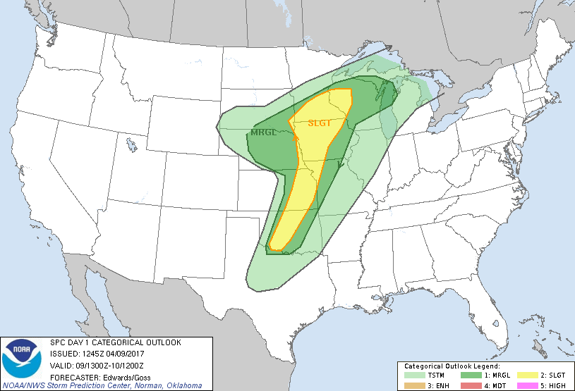
MARGINAL
171,793
6,868,959
Tulsa, OK...Lincoln, NE...Cedar Rapids, IA...Wichita Falls, TX...Green Bay, WI...
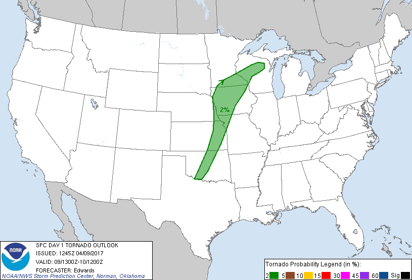
Probabilistic Tornado Graphic
Probability of a tornado within 25 miles of a point. Hatched Area: 10% or greater probability of EF2 - EF5 tornadoes within 25 miles of a point.
Day 1 Tornado Risk
Area (sq. mi.)
Area Pop.
Some Larger Population Centers in Risk Area
2 %
100,601
6,926,019
Oklahoma City, OK...Omaha, NE...Des Moines, IA...Kansas City, KS...Topeka, KS...
Probabilistic Damaging Wind Graphic
Probability of damaging thunderstorm winds or wind gusts of 50 knots or higher within 25 miles of a point. Hatched Area: 10% of greater probability of wind gusts 65 knots or greater within 25 miles of a point.
Day 1 Wind Risk
Area (sq. mi.)
Area Pop.
Some Larger Population Centers in Risk Area
15 %
106,126
8,317,377
Oklahoma City, OK...Kansas City, MO...Omaha, NE...Wichita, KS...Des Moines, IA...
5 %
194,007
10,799,458
Tulsa, OK...Minneapolis, MN...St. Paul, MN...Lincoln, NE...Sioux Falls, SD...
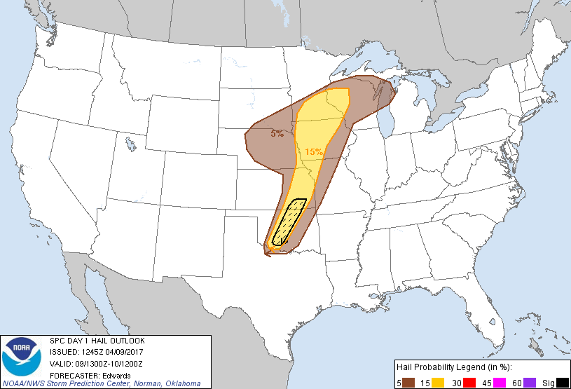
Probabilistic Large Hail Graphic
Probability of hail 1" or larger within 25 miles of a point. Hatched Area: 10% or greater probability of hail 2" or larger within 25 miles of a point.
Day 1 Hail Risk
Area (sq. mi.)
Area Pop.
Some Larger Population Centers in Risk Area
SIG SEVERE
16,114
1,658,320
Oklahoma City, OK...Norman, OK...Lawton, OK...Edmond, OK...Midwest City, OK...
15 %
123,235
11,872,392
Oklahoma City, OK...Kansas City, MO...Omaha, NE...Minneapolis, MN...Wichita, KS...
5 %
178,749
7,402,098
Tulsa, OK...Lincoln, NE...Sioux Falls, SD...Cedar Rapids, IA...Wichita Falls, TX...
   SPC AC 091245

   Day 1 Convective Outlook
   NWS Storm Prediction Center Norman OK
   0745 AM CDT Sun Apr 09 2017

   Valid 091300Z - 101200Z

   ...THERE IS A SLIGHT RISK OF SEVERE THUNDERSTORMS FROM PORTIONS OF
   THE UPPER MISSISSIPPI VALLEY REGION TO SOUTHWESTERN OKLAHOMA...

   ...THERE IS A MARGINAL RISK OF SEVERE THUNDERSTORMS SURROUNDING THE
   SLIGHT RISK AND BULGING WESTWARD OVER MUCH OF NEBRASKA AND
   SOUTHEASTERN SOUTH DAKOTA....

   ...SUMMARY...
   Large hail and damaging wind gusts are possible this afternoon from
   parts of the upper Mississippi Valley to central/southwestern
   Oklahoma.  Isolated very large and damaging hail is possible from
   southern Kansas to central and southwestern Oklahoma.  A tornado
   cannot be ruled out.

   ...Synopsis...
   A progressive upper-air pattern is forecast to persist through the
   period, the most pertinent feature being troughing now evident in
   moisture-channel imagery from central/eastern UT across the Four
   Corners and roughly down the AZ/NM border.  The northern part of
   that is a high-amplitude shortwave perturbation that will deepen
   further and assume negative tilt over WY and northern CO by 00Z.
   From that, a closed 500-mb low should develop near the Black Hills
   and move generally eastward across eastern SD overnight.  Meanwhile,
   the weaker but still readily apparent southern vorticity segment
   should eject northeastward to central portions of KS/OK by 00Z, then
   weaken and accelerate northeastward across the mid/upper Mississippi
   Valley overnight.

   At the surface, 11Z analysis showed a wavy dryline from the
   mountains of northern Coahuila across the southeast corner of NM,
   northeastward to extreme western OK, then generally northward to a
   surface low over the Platte Valley between GRI-EAR.  A cold front
   extended from that low to northeast CO, with a warm front over
   eastern NE, western/northern IA, and southern WI.  The dryline will
   mix eastward today and become more sharply defined as moist
   advection continues to its east.  By 00Z, the dryline should extend
   from northern Coahuila northeastward to west-central and
   north-central OK, intersecting the cold front at or not far
   southwest of a surface low over southeastern NE.  The warm front
   will have moved only slightly northward to northwestern IA,
   southeastern MN and central WI.  By the end of the period, the low
   should accelerate northeastward to near LSE, cold front
   southwestward across northern MO, south-central OK, and southeastern
   NM.

   Because of the conditional nature of much of this outlook and the
   presence of substantial EML-related CINH, parts of this outlook may
   see no appreciable convection in between regionally isolated
   clusters of severe weather.  However, mesoscale uncertainties still
   are great enough to preclude breaking the slight-risk swath into
   unconditionally more-favored nodes at this time.

   ...Upper Mississippi Valley region to Missouri Valley...
   Widely scattered to scattered thunderstorms are expected to develop
   from late afternoon through this evening on either side of the
   surface warm front -- both atop the elevated frontal slope and
   farther south from the surface low along the cold front.  Activity
   accessing warm-sector inflow will pose a damaging-wind threat as
   well as the broader large-hail potential.  Available buoyancy and
   liquid-water content each will be relatively limited north of the
   warm front, with forecast soundings showing mean-mixing ratios of
   around 8 g/kg and elevated MUCAPE 1000-1500 J/kg in the area of
   strongest frontogenetic/warm-advection-related forcing.  However,
   cloud-layer and effective shears are strong, the latter consistently
   reading at 50-65 kt in forecast soundings.  The potential for one or
   two longer-tracked hail swaths north of the warm front accounts for
   lateral flaring in the shape of the 15%/slight risk area.

   Several thunderstorms or a few clusters of storms also may form
   along/ahead of the surface cold front southward to the Missouri
   Valley region, in an environment of surface dew points increasing to
   the upper 50s and low 60s F.  40-50 kt effective-shear magnitudes
   are expected, indicating at least conditional supercell potential.
   However, the weak orthogonal component of flow aloft with respect to
   the boundary orientation, combined with a forecast veer-back-veer
   wind profile with height, indicate convective mode may be somewhat
   linear or messy and clustered rather quickly.

   ...Central/southern Plains...
   The severe threat becomes more conditional, spotty and uncertain
   with southward extent along and ahead of the dryline.  This is
   because of warmer EML-base temps and related strong capping, and
   uncertainty in mesobeta- to local-scale lifting mechanisms needed to
   power parcels through the inversion layer long enough to sustain
   updraft columns.  Strong surface heating with 60s F surface dew
   points and around 12 g/kg mean mixing ratio are likely north of some
   cirrus over northwest TX, and several higher-resolution progs
   suggest a favorably oriented dryline bulge or two to enhance
   convergence within this swath.  Convection-allowing guidance has
   been wildly inconsistent, spanning a vast spectrum from one model
   type to another in terms of coverage.

   Any storm that can form and last at least 2-3 hours in an otherwise
   favorable parameter space for supercells (peak MLCAPE 2500-3000
   J/kg, 50-60 kt effective-shear magnitude, high CAPE density with
   large proportion of buoyancy in ideal hail-growth zones) will be
   capable of damaging hail and localized severe gusts.  Given the
   likely low storm count, but the potential for isolated very
   large/destructive hail, a significant-hail area is introduced and
   may need further refinement as mesoscale details become more clear.
   Farther south into TX, the combination of weaker convergence,
   stronger CINH and weaker deep shear will preclude a
   substantial/unconditional severe threat.  Tornado potential, if any,
   should be in a relatively small time window near dusk, given the
   presence of a discrete supercell, as LCLs lower but before SBCINH
   becomes too great for internal storm dynamics to maintain
   surface-based inflow through the cooling near-surface layer.

   ...Portions of NE, southern SD...
   Though somewhat moisture- and buoyancy-starved, the low-level air
   mass behind the surface low and cold front and ahead of the strong
   northern-branch shortwave trough still may support an arc or cluster
   of thunderstorms this afternoon and evening.  Activity should move
   eastward to east-northeastward across the area, offering isolated
   severe hail and gusts penetrating to the surface.  Forecast
   soundings suggest sufficient cooling aloft, atop the marginally
   moist frontal layer, to yield MUCAPE 500-1000 J/kg, amidst about
   35-45 kt effective-shear magnitude.

   ..Edwards/Goss.. 04/09/2017

   CLICK TO GET WUUS01 PTSDY1 PRODUCT

   NOTE: THE NEXT DAY 1 OUTLOOK IS SCHEDULED BY 1630Z