SPC AC 121257
Day 1 Convective Outlook
NWS Storm Prediction Center Norman OK
0757 AM CDT Wed Apr 12 2017
Valid 121300Z - 131200Z
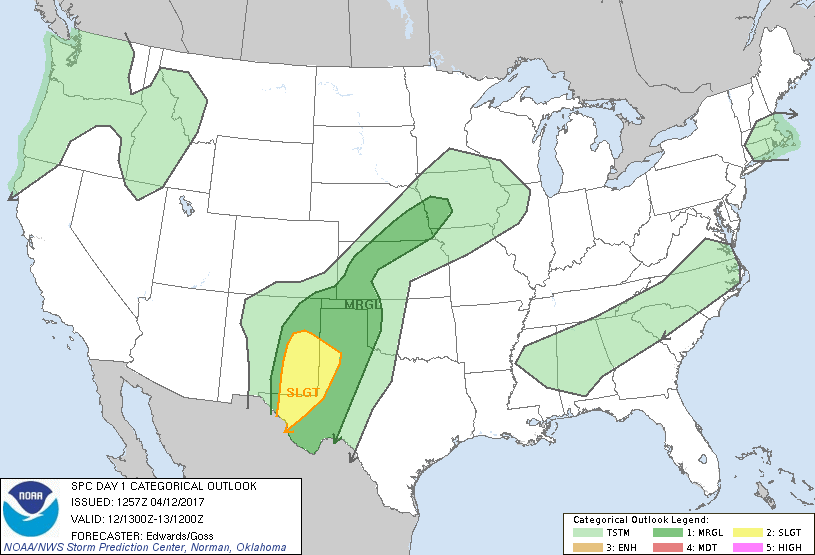
...THERE IS A SLIGHT RISK OF SEVERE THUNDERSTORMS OVER PARTS OF WEST
TEXAS AND EASTERN NEW MEXICO...
...THERE IS A MARGINAL RISK OF SEVERE THUNDERSTORMS ELSEWHERE FROM
WEST TEXAS TO PARTS OF THE MID MISSOURI VALLEY REGION...
...SUMMARY...
A few severe storms, capable of damaging winds and large hail, will
be possible across portions of the southern and central Plains, with
the highest likelihood over southeastern New Mexico and far west
Texas.
...Synopsis...
Though low-amplitude on the synoptic scale over land, the upper-air
pattern will remain progressive and active on shortwave scales. A
somewhat-phased northern/southern-stream trough is apparent from the
upper Great Lakes to OH, then over the western slope of the
Appalachians to northern MS, to offshore southern LA. The northern
part of this feature will move eastward across the Lower Great Lakes
and northern Mid Atlantic today, then offshore New England near the
end of the period. The southern part will move more slowly across
the Southeast, reaching the Piedmont of GA and the Carolinas around
00Z, southwestward over the FL Panhandle.
A southern-stream shortwave trough -- currently over southwestern
CO, eastern AZ and northwestern MX, will move slowly eastward to the
southern High Plains, Big Bend region, and Chihuahua through 12Z. A
large, complex synoptic cyclone over the northeastern Pacific will
shift slowly eastward while being orbited by numerous mesoscale
perturbations and one fairly pronounced, basal shortwave trough.
The latter should move ashore northern CA and southern OR in the
06-12Z time frame, preceded by a low-level frontal band from midday
through afternoon. Isolated thunder potential exists with this
system.
At the surface, 11Z analysis showed a cold front from a weak low
over southeastern NY, southwestward across western NC, northern GA
and central MS, becoming quasistationary over the Arklatex region
and north TX, and a warm front over northwest TX and the South
Plains region into eastern NM. An older, wavy, quasistationary
frontal segment was drawn from central AL southwestward across the
northwestern Gulf to an area of convective outflow over northeastern
MX, re-emerging over northern Chihuahua to a weak low south of ELP.
Both frontal segments over the southern High Plains and northern MX
will shift northward through the period and slowly become more
ill-defined, while the eastern U.S. front proceeds eastward off the
Atlantic coast. Another weak low, analyzed over the southern
Nebraska Panhandle, is expected to migrate to central IA by 12Z,
while a weak/trailing cold front settles southward across Nebraska
to near the Kansas border, then becomes quasistationary. This
afternoon, a surface trough should extend from a weak low over
southeastern CO/southwestern KS northeastward to the front in
southern/eastern NE.
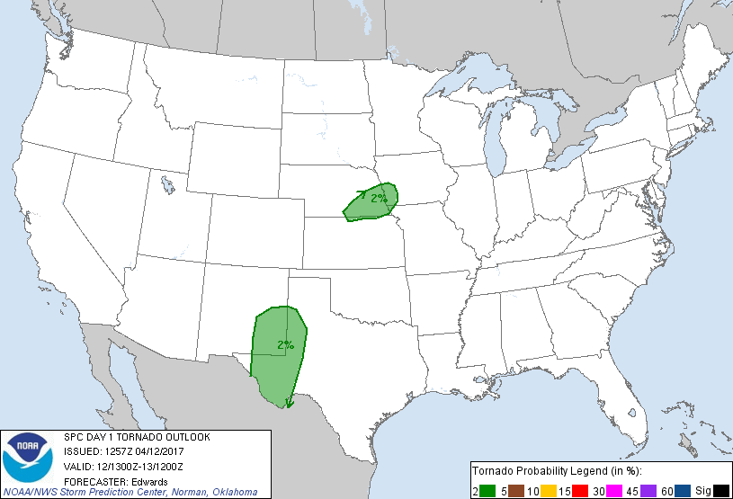
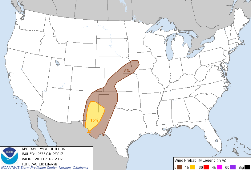
...Trans-Pecos to south-central High Plains...
Widely scattered to isolated thunderstorms, with the threat for
isolated severe hail, already have formed over parts of southern NM
in a zone of juxtaposed low-level warm/moist advection, large-scale
lift related to the southern-stream trough aloft, and frontal and
orographic forcing. These factors will continue, and will spatially
expand the threat for and density of strong-severe thunderstorms
across the remainder of the outlook through the day and into this
evening, in concert with preconvective/diabatic surface
destabilization. Surface dew points increasing into the 60s F and
surface heating south and east of ongoing convection, beneath steep
midlevel lapse rates, will support a boost of MLCAPE to the
1000-2000 J/kg range, amidst favorably veering flow with height and
40-50 kt effective-shear magnitudes. A mix of multicells and
supercells is expected, with some loosely organized upscale growth
possible into the evening. At the same time, a strengthening LLJ
should enlarge hodographs and continue the supercell risk, including
the conditional possibility of a tornado with any remaining
relatively discrete convection, prior to general overnight diabatic
cooling/stabilization. The hail/isolated wind threat with some
activity may persist well into the late-overnight hours.
...Mid Missouri Valley to western KS...
Scattered to widely scattered thunderstorms should develop this
afternoon - some persisting into early evening -- along and ahead of
the surface cold front and trough. Moist advection and surface
diabatic heating will act in concert with steep midlevel lapse rates
to destabilize the foregoing air mass this afternoon, with forecast
soundings suggesting the development of around 1500 J/kg MLCAPE,
locally approaching 2000 J/kg. While low/middle-level flow will not
be particularly strong, veering flow with height and modest bulk
shear -- e.g., effective-shear magnitudes 30-40 kt -- will engender
organized multicell and isolated supercell potential, with
associated large-hail/damaging-gust risk. A tornado also cannot be
ruled out, but is more dependent on the vagaries of the storm scale
than mesoscale and broader processes. A relative min in
convective/severe potential may still exist over parts of
western/southwestern KS south of the surface trough; however, the
min has become small and uncertain enough that the marginal-risk
areas can be effectively merged.
...New England...
A band of shallow, mainly elevated convection is forecast to move
rapidly northeastward across parts of southern and eastern New
England from late morning through mid afternoon, amidst strong
mid/upper-level flow. Locally strong gusts may penetrate to the
surface from a few embedded cells whose downdrafts transport
momentum from aloft. However, severe-wind potential appears too low
and brief for an areal outlook at this time. Forecast soundings
suggest well-mixed boundary layers where sufficient surface diabatic
heating can occur, but low theta-e and thus a lack of low-level
buoyancy. Weakly supportive midlevel instability should develop in
the zone of DCVA ahead of the northern-stream trough, and beneath
the right-entrance region of a roughly 100-kt 250-mb jet streak.
CAPE appears meager and elevated -- barely enough for a thunder
outlook, as it now stands -- with MUCAPE generally under 200 J/kg
and rooted near 800 mb.
...Southern VA to northern GA...
Isolated to widely scattered thunderstorms are possible mainly
midday through afternoon, along/ahead of the surface front.
Antecedent surface dew points in the 50s F will support this
convection, in concert with a combination of strong surface diabatic
heating, lift near the front, weakening CINH, and some midlevel
destabilization ahead of the southern-branch trough. A relatively
dry and well-mixed subcloud layer may support locally strong gusts
in a few cells. However, weak low/middle-level flow, related lack
of deep shear, and lack of more robust buoyancy, should keep
potential for severe convective wind too low and conditional for an
outlook.
..Edwards/Goss.. 04/12/2017
CLICK TO GET WUUS01 PTSDY1 PRODUCT
NOTE: THE NEXT DAY 1 OUTLOOK IS SCHEDULED BY 1630Z
|