Brownsville, TX...Harlingen, TX...Rapid City, SD...Mission, TX...Pharr, TX...
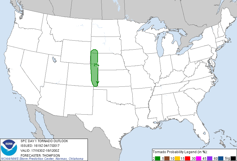
Probabilistic Tornado Graphic
Probability of a tornado within 25 miles of a point. Hatched Area: 10% or greater probability of EF2 - EF5 tornadoes within 25 miles of a point.
Day 1 Tornado Risk
Area (sq. mi.)
Area Pop.
Some Larger Population Centers in Risk Area
2 %
35,746
186,539
Scottsbluff, NE...Sterling, CO...Lamar, CO...
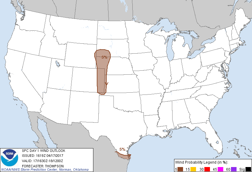
Probabilistic Damaging Wind Graphic
Probability of damaging thunderstorm winds or wind gusts of 50 knots or higher within 25 miles of a point. Hatched Area: 10% of greater probability of wind gusts 65 knots or greater within 25 miles of a point.
Day 1 Wind Risk
Area (sq. mi.)
Area Pop.
Some Larger Population Centers in Risk Area
5 %
69,977
1,564,952
Brownsville, TX...Harlingen, TX...Rapid City, SD...Mission, TX...Pharr, TX...
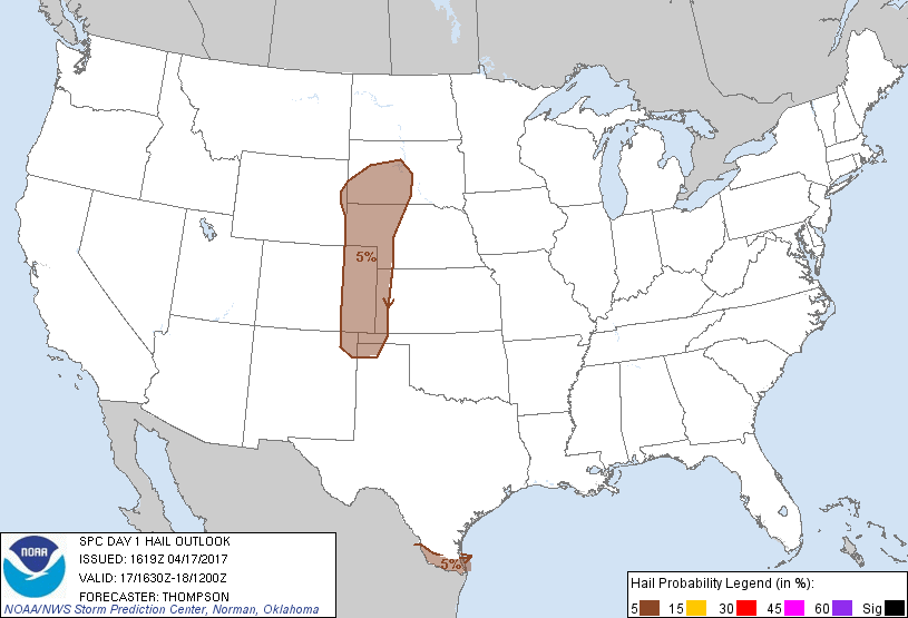
Probabilistic Large Hail Graphic
Probability of hail 1" or larger within 25 miles of a point. Hatched Area: 10% or greater probability of hail 2" or larger within 25 miles of a point.
Day 1 Hail Risk
Area (sq. mi.)
Area Pop.
Some Larger Population Centers in Risk Area
5 %
107,662
1,734,486
Brownsville, TX...Harlingen, TX...Rapid City, SD...Mission, TX...Pharr, TX...
SPC AC 171619
Day 1 Convective Outlook
NWS Storm Prediction Center Norman OK
1119 AM CDT Mon Apr 17 2017
Valid 171630Z - 181200Z
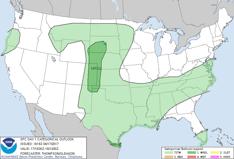
...THERE IS A MARGINAL RISK OF SEVERE THUNDERSTORMS THIS AFTERNOON
INTO EARLY TONIGHT FOR PARTS OF THE CENTRAL/NORTHERN HIGH PLAINS...
...THERE IS A MARGINAL RISK OF SEVERE THUNDERSTORMS THIS AFTERNOON
ALONG THE LOWER RIO GRANDE VALLEY...
...SUMMARY...
Very isolated severe thunderstorms with hail and strong wind gusts
are expected across parts of the High Plains and the lower Rio
Grande Valley this afternoon and evening.
...Western SD area late this afternoon into early tonight...
A compact shortwave trough over ID this morning will reach the
northern High Plains by this evening, and continue eastward over the
Dakotas/MN overnight. Associated lee cyclogenesis will help draw
low-level moisture northward across the High Plains, while surface
heating in cloud breaks and advection of steeper midlevel lapse
rates from the west contribute to near-surface destabilization as
far north as southwestern SD. Thunderstorms that develop by late
afternoon could be rooted at the surface near and south of the Black
Hills, and convection will likely be elevated farther
north-northeast. The focused forcing for ascent, weak buoyancy, and
strong cloud-layer vertical shear will support at least a low-end
risk for hail/damaging winds from late afternoon through early
tonight.
...Western NE to southeastern CO this afternoon/evening...
Low-level moisture (dewpoints in the low-mid 50s) is beginning to
return northward across the High Plains from southeastern CO to
western NE, with evidence of weak terrain-driven cyclonic
circulations in CO near La Junta and northeast of Denver. Some
cloud breaks by afternoon along the west edge of the richer moisture
will allow surface heating and weakening of the cap from below, and
the development of MLCAPE ranging from 1500 J/kg in southeastern CO
to 500 J/kg across western NE. Isolated thunderstorm development is
expected by late afternoon, possibly in conjunction with the
lingering terrain circulations. Though mid-upper flow is weak this
morning, some increase is expected by afternoon/evening as far south
as eastern CO, where some increase in low-level shear will also
occur. The net result will be an environment at least marginally
favorable for supercells capable of producing isolated large hail,
damaging gusts, and perhaps a tornado.
...South TX this afternoon...
An MCV is drifting eastward over the middle/lower TX coast as of mid
morning, and much of south TX has been somewhat stabilized by the
overnight convection (see the 12z CRP sounding). Outflow from the
convection may retreat to just north of the international border
along the lower Rio Grande River, and provide a focus for additional
storm development this afternoon. The mesoscale storm environment
will be at least marginally favorable for supercells, with an
attendant risk for isolated large hail/damaging winds near the
international border. Farther north, other than some elevated
convection associated with warm advection atop the remnant cold
pool, it is not clear that destabilization will be sufficient for
additional strong/severe storm development this afternoon.
...North TX to western TN this afternoon...
Convection will likely develop and/or persist along an outflow
boundary from western TN across southern AR to north TX. An
isolated pulse-type downburst and/or small hail cannot be ruled out
(especially north TX), but weak vertical shear and at best moderate
buoyancy suggest that the severe-storm risk is too marginal to
warrant the introduction of an outlook area.
...Northern NC/southeastern VA this afternoon...
Strong surface heating will boost afternoon surface temperatures to
the lower 80s, though poor midlevel lapse rates and modest low-level
moisture will limit MLCAPE to at or below 500 J/kg. There will be
some potential for gusty outflow winds with convection along the
front, where low-level lapse rates will be steep along the southern
fringe of 25-30 kt midlevel flow. Still, the marginal buoyancy and
modest flow suggest the damaging wind risk is too marginal to add an
outlook area.
..Thompson/Gleason.. 04/17/2017
CLICK TO GET WUUS01 PTSDY1 PRODUCT
NOTE: THE NEXT DAY 1 OUTLOOK IS SCHEDULED BY 2000Z