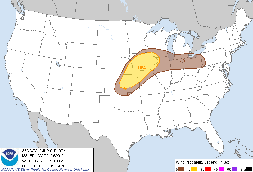
Lincoln, NE...Des Moines, IA...Waterloo, IA...Ames, IA...West Des Moines, IA...
2 %
42,877
1,638,651
Cedar Rapids, IA...Topeka, KS...St. Joseph, MO...Iowa City, IA...Dubuque, IA...
Probabilistic Damaging Wind Graphic
Probability of damaging thunderstorm winds or wind gusts of 50 knots or higher within 25 miles of a point. Hatched Area: 10% of greater probability of wind gusts 65 knots or greater within 25 miles of a point.
Day 1 Wind Risk
Area (sq. mi.)
Area Pop.
Some Larger Population Centers in Risk Area
15 %
109,079
7,466,693
Kansas City, MO...Omaha, NE...Lincoln, NE...Des Moines, IA...Overland Park, KS...
SPC AC 191630
Day 1 Convective Outlook
NWS Storm Prediction Center Norman OK
1130 AM CDT Wed Apr 19 2017
Valid 191630Z - 201200Z
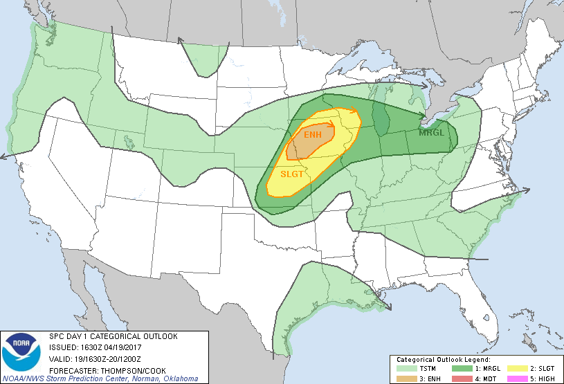
...THERE IS AN ENHANCED RISK OF SEVERE THUNDERSTORMS THIS
AFTERNOON/EVENING FOR SOUTHEAST NEBRASKA AND PARTS OF
WESTERN/CENTRAL IOWA...
...THERE IS A SLIGHT RISK OF SEVERE THUNDERSTORMS SURROUNDING THE
ENHANCED RISK AREA...FROM SOUTHWEST WISCONSIN TO NORTHEAST KANSAS...
...THERE IS A MARGINAL RISK OF SEVERE THUNDERSTORMS SURROUNDING THE
SLIGHT RISK AREA...FROM NORTHERN OKLAHOMA TO LOWER MICHIGAN AND
NORTHERN OHIO...
...SUMMARY...
Severe thunderstorms capable of producing large hail, damaging
winds, and a few tornadoes will be possible from the central Plains
to the upper Mississippi Valley mainly from mid-afternoon into
tonight.
...Northeast KS to IA and southwest WI through tonight...
A low-amplitude midlevel trough over the central High Plains will
progress eastward to the mid MO Valley by this evening, and continue
to the upper MS Valley overnight. An associated surface cyclone
near the KS/NE border will develop east-northeastward along a warm
front to southeast NE this afternoon and southwest WI by early
Thursday. Boundary layer dewpoints in the lower 60s are spreading
northward south of the warm front, and will combine with daytime
heating and steep midlevel lapse rates to support MLCAPE near 1500
J/kg.
Lingering convective inhibition suggests that thunderstorm
development this afternoon/evening will largely be confined to the
synoptic cold front, and in the zone of isentropic ascent north of
the warm front and immediately in advance of the surface cyclone.
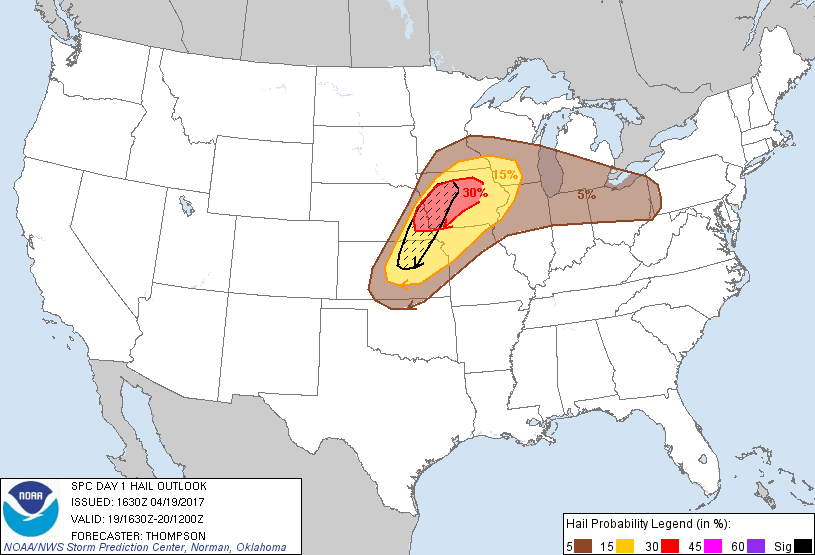
Moderate buoyancy and strong deep-layer shear (effective bulk shear
near 50 kt) will support a risk for supercells, and storms should
remain semi-discrete given substantial cross-boundary flow/shear
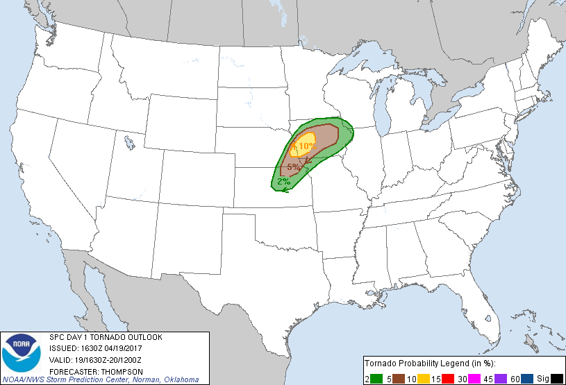
vectors. The strongest storms will be capable of producing isolated
very large hail and damaging winds. Low-level shear will be
strongest near the surface warm front, where the tornado risk will
be greatest for a few hours this evening when storms are most
probable to remain discrete, and before convective inhibition
strengthens with diurnal cooling of the boundary layer. The
northern extent of any tornado risk will be delineated by strong
static stability immediately north of the warm front.
Convection will likely develop southwestward along the cold front
this evening across KS, and could persist into the overnight hours
as the frontal convection sags southward. Otherwise, it is not
clear that the afternoon/evening supercells will persist overnight
and very far east across IA, since the stronger forcing for ascent
will tend to spread more toward WI in the warm advection zone, where
isolated large hail will be possible.
...Southern Lower MI, northern IN and northern OH this afternoon...
A possible weak MCV over northern IL will move eastward through the
afternoon. Modest destabilization of the boundary layer to the east
may support a few small clusters of storms that will subsequently
move eastward through the afternoon over southern Lower MI, northern
IN, and northern OH. Isolated damaging winds and marginally severe
hail will be possible.
..Thompson/Cook.. 04/19/2017
CLICK TO GET WUUS01 PTSDY1 PRODUCT
NOTE: THE NEXT DAY 1 OUTLOOK IS SCHEDULED BY 2000Z