Little Rock, AR...Tyler, TX...Fort Smith, AR...Longview, TX...North Little Rock, AR...
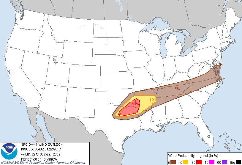
Probabilistic Damaging Wind Graphic
Probability of damaging thunderstorm winds or wind gusts of 50 knots or higher within 25 miles of a point. Hatched Area: 10% of greater probability of wind gusts 65 knots or greater within 25 miles of a point.
Memphis, TN...Little Rock, AR...Tyler, TX...Fort Smith, AR...Longview, TX...
5 %
186,429
22,239,239
Nashville, TN...Virginia Beach, VA...Raleigh, NC...Norfolk, VA...Greensboro, NC...
SPC AC 220048
Day 1 Convective Outlook
NWS Storm Prediction Center Norman OK
0748 PM CDT Fri Apr 21 2017
Valid 220100Z - 221200Z
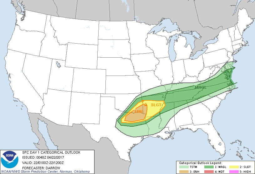
...THERE IS AN ENHANCED RISK OF SEVERE THUNDERSTORMS FROM PORTIONS
OF NORTH CENTRAL TX TO SOUTHWEST AR...
...THERE IS A SLIGHT RISK OF SEVERE THUNDERSTORMS FROM NORTH TX TO
NORTHWEST MS...
...THERE IS A MARGINAL RISK OF SEVERE THUNDERSTORMS FROM THE
SOUTHERN PLAINS TO THE MIDDLE ATLANTIC COAST...
...SUMMARY...
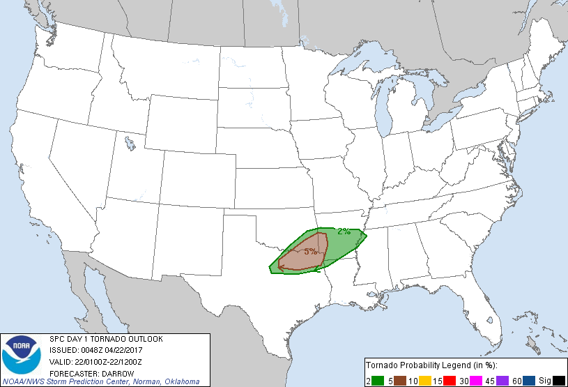
Severe thunderstorms capable of producing damaging gusts, large hail
and a few tornadoes are expected through tonight from North Central
Texas into Arkansas. Isolated severe thunderstorms may also impact
portions of the Mid-South into the Mid-Atlantic with wind and hail.
...North Central TX to AR...
Large-scale height falls will spread into the Mid/Lower MS Valley
overnight as primary mid-level speed max digs across northern OK
into northern AR. Deep convection is responding to this feature
with scattered thunderstorms increasing in areal coverage along a
corridor from portions of the Ozark Plateau to west of the DFW
Metroplex. 00z sounding from FWD exhibits seasonally steep
mid-level lapse rates with adequate moisture for robust
thunderstorms this evening. Shear profiles favor south of east
movement for right-moving supercells and large hail can be expected
with these sustained updrafts. Later this evening, LLJ will respond
to aforementioned mid-level speed max with speeds approaching 50kt
by midnight over AR. Low-level warm advection will enhance ascent
atop rain-cooled air mass and considerable amount of elevated
convection should evolve ahead of frontal convection. Large hail is
the primary threat with elevated activity but damaging winds and a
few tornadoes may also be noted with near-surface based supercells.
...Middle Atlantic...
Small cluster of strong/severe thunderstorms is progressing across
the Chesapeake Bay region and will weaken or move offshore by 02z.
Isolated hail/wind may accompany this activity for the next hour or
so.
Will maintain MRGL severe threat across the TN Valley region for
gusty winds and marginally severe hail in association with weak MCS
as it propagates toward the higher terrain of eastern TN/western NC.
..Darrow.. 04/22/2017
CLICK TO GET WUUS01 PTSDY1 PRODUCT
NOTE: THE NEXT DAY 1 OUTLOOK IS SCHEDULED BY 0600Z