Savannah, GA...Hilton Head Island, SC...Hinesville, GA...Martinez, GA...Statesboro, GA...
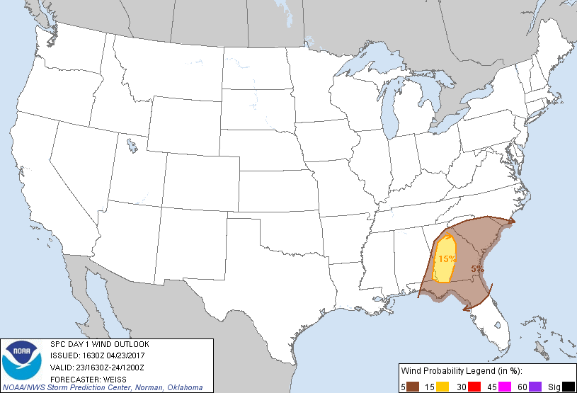
Probabilistic Damaging Wind Graphic
Probability of damaging thunderstorm winds or wind gusts of 50 knots or higher within 25 miles of a point. Hatched Area: 10% of greater probability of wind gusts 65 knots or greater within 25 miles of a point.
SPC AC 231630
Day 1 Convective Outlook
NWS Storm Prediction Center Norman OK
1130 AM CDT Sun Apr 23 2017
Valid 231630Z - 241200Z
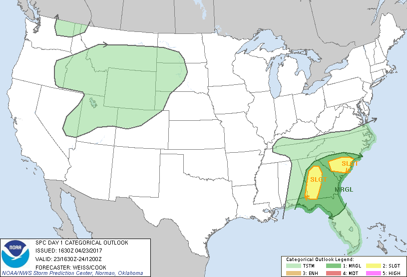
...THERE IS A SLIGHT RISK OF SEVERE THUNDERSTORMS OVER
WESTERN/CENTRAL GEORGIA...
...THERE IS A SLIGHT RISK OF SEVERE THUNDERSTORMS OVER SOUTH
CAROLINA...
...THERE IS A MARGINAL RISK OF SEVERE THUNDERSTORMS FROM NORTHERN
FLORIDA INTO GEORGIA AND SOUTH CAROLINA...
...SUMMARY...
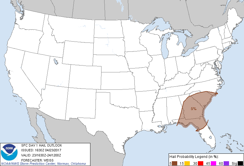
Areas of strong-severe thunderstorms are expected over the Southeast
today and overnight. The main threats appear to be damaging gusts
over parts of western/central Georgia and central South Carolina
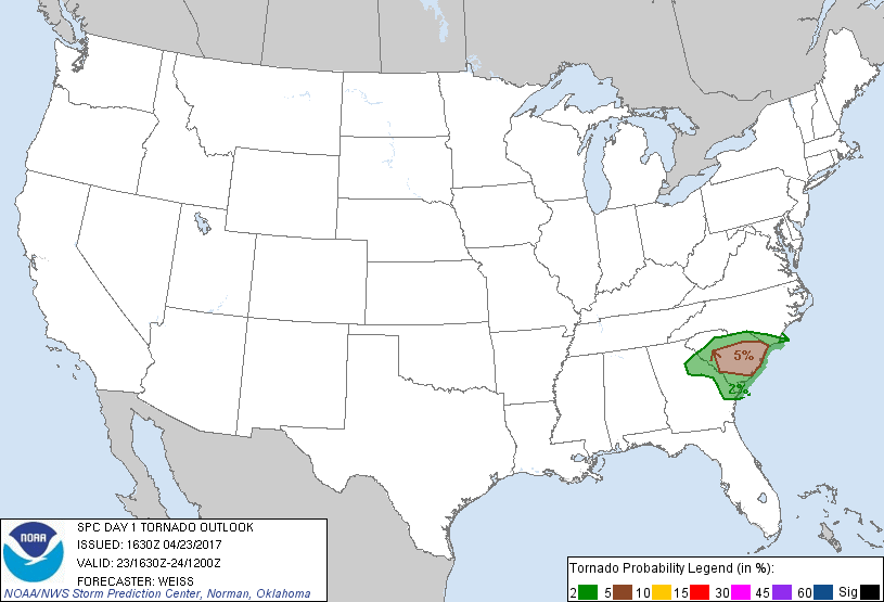
this afternoon, followed by potential for a few tornadoes and
isolated wind damage overnight in parts of South Carolina.
...Georgia and South Carolina...
Satellite imagery indicates an upper low has formed over western
Tennessee, and this feature is forecast to move southeastward
reaching the Alabama/Georgia border by the end of the period. A
band of stronger mid/upper level winds curving cyclonically around
the southern periphery of the circulation is expected to spread
across parts of Georgia and northern Florida into tonight.
At the surface, a low over extreme northwest Georgia will move
mainly eastward along a quasi-stationary front extending across
east-central Georgia to the central South Carolina coast. The low
is forecast to reach east-central Georgia this evening and cross
into South Carolina by 24/12Z. A cold front trailing southward from
the low will progress eastward to the Atlantic coast from Georgia to
northeast Florida by the end of the period. The frontal boundaries
are expected to focus the stronger thunderstorm activity through
tonight.
Initial storm development is expected along the advancing cold front
by early afternoon from west central Georgia into the Florida
Panhandle as it moves into an axis of slightly greater moisture.
Although mid-level lapse rates are generally weak, visible satellite
imagery indicates stronger diabatic heating will occur in the warm
sector where fewer clouds are present. This will enhance low-level
lapse rates and contribute to modest destabilization with MLCAPE of
500-1000 J/kg this afternoon. With some CAM guidance indicating
development of QLCS structures along/slightly ahead of the front,
stronger cells within the line segments will have potential to
produce damaging downbursts as they move through the focused
moisture/instability axis. See Mesoscale Discussion 550 for more
detailed information.
Other storms are expected to develop over parts of central/southern
South Carolina this afternoon near the aforementioned east-west
front. The lack of clouds south of the boundary is promoting a
strong differential heating zone where attendant mesoscale
circulations will support storm potential this afternoon. Isolated
severe storms will be possible as vertical shear increases over the
area, especially along and immediately north of the boundary where
backed surface flow will enhance low-level shear.
The severe threat over South Carolina is expected to increase
somewhat tonight as a south-southeasterly low-level jet strengthens
in response to the approaching upper low. This will result in
increasing moisture advection from the Atlantic and be associated
with stronger low-level shear with an attendant risk for supercells
to develop. Low LCL levels and moderate-strong SRH indicate
potential for a few tornadoes to occur with any persistent discrete
supercells that develop.
...Northern/Central Utah...
Isolated weak thunderstorms may develop this afternoon and evening
in association with an upper short wave trough that will move
eastward across the Great Basin. Column moisture/total precipitable
water values are quite minimal /approximately 0.25 inch/ which will
limit the coverage and intensity of any convection. However, a dry
sub-cloud layer will enhance evaporative cooling and promote
transfer of stronger mid-level horizontal momentum to the surface,
suggesting potential for convectively-enhanced surface wind gusts.
Given the aforementioned limiting factors, we will maintain a
sub-severe outlook at this time over the area.
..Weiss/Cook.. 04/23/2017
CLICK TO GET WUUS01 PTSDY1 PRODUCT
NOTE: THE NEXT DAY 1 OUTLOOK IS SCHEDULED BY 2000Z