SPC AC 271255
Day 1 Convective Outlook
NWS Storm Prediction Center Norman OK
0755 AM CDT Thu Apr 27 2017
Valid 271300Z - 281200Z
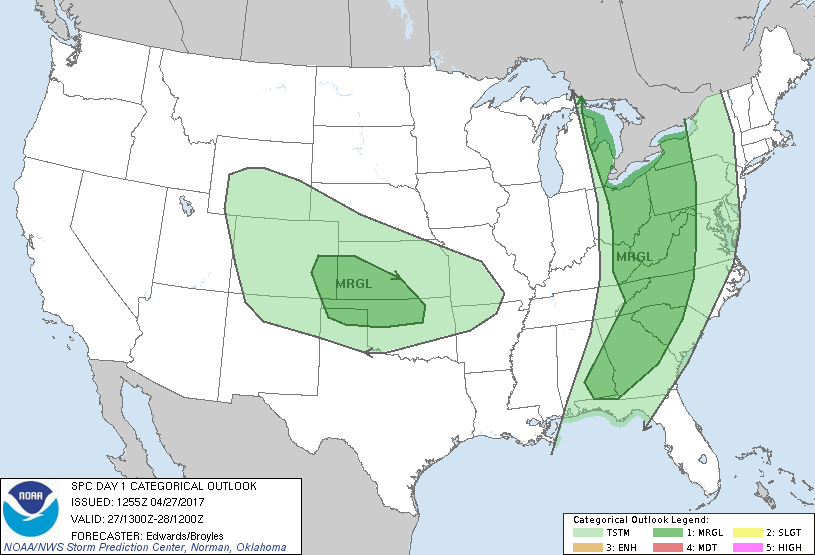
...THERE IS A MARGINAL RISK OF SEVERE THUNDERSTORMS FROM PARTS OF
ALABAMA AND GEORGIA TO PARTS OF THE GREAT LAKES...
...THERE IS A MARGINAL RISK OF SEVERE THUNDERSTORMS FROM
SOUTHEASTERN COLORADO ACROSS PARTS OF KANSAS...NORTHWESTERN
OKLAHOMA...AND PARTS OF THE OKLAHOMA AND TEXAS PANHANDLES...
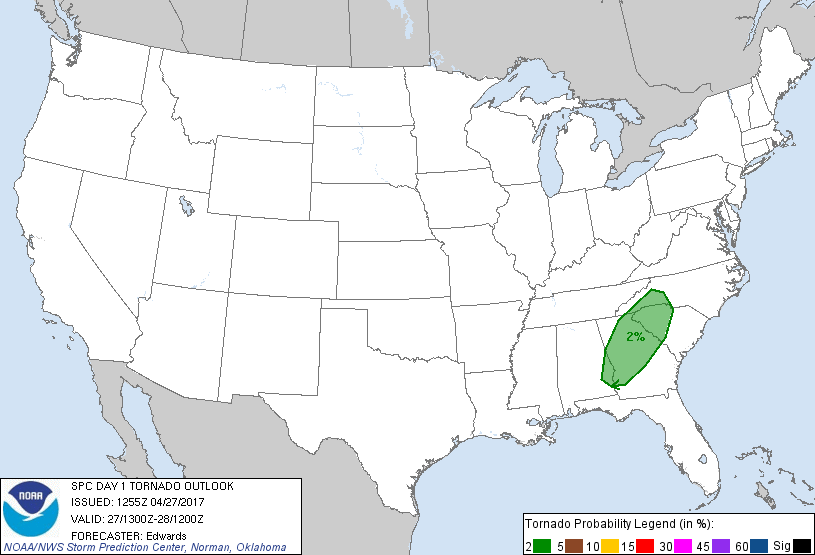
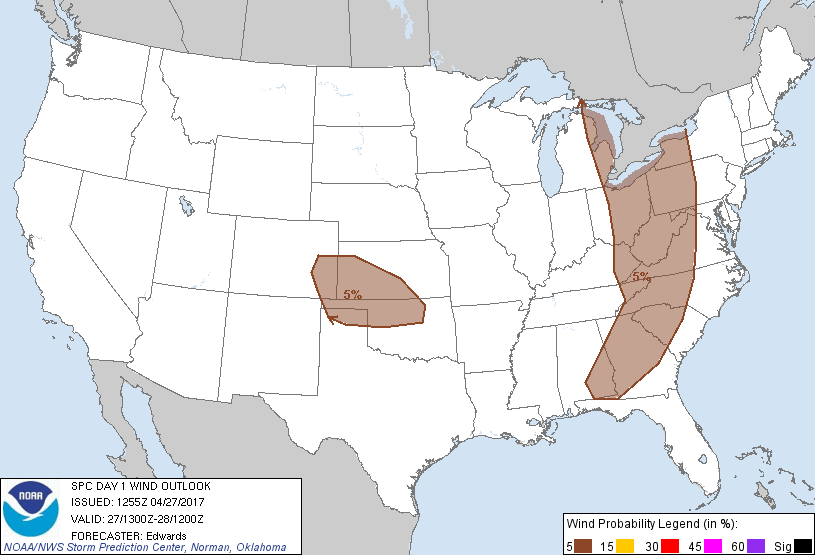
...SUMMARY...
Isolated severe wind gusts may accompany thunderstorms from portions
of the Great Lakes region to the Southeast States today into this
evening, and across portions of the central and southern Great
Plains late this afternoon into this evening.
...Synopsis...
In mid/upper levels, mean troughing will persist across the
west-central U.S., as one leading perturbation ejects away, and
others reinforce the associated cyclonic flow and height deficit.
That leading perturbation -- currently located from a vorticity max
over northern IL southward across MS -- will move to WV, OH and
eastern lower MI by 00Z, phasing with a 500-mb low now over the
Northwest Angle region of MN. Thereafter, it will eject
northeastward into Canada, as synoptic-scale amplification occurs to
the troughing over the Rockies and High Plains.
At the surface, the 11Z analysis showed a low over the western shore
of Lake Michigan between MKE-GRB, with cold front to southern IN,
middle TN, southeastern MS, and the northwestern Gulf. The low will
eject northeastward across James Bay through tonight. By 00Z the
cold front is expected to reach western NY, WV, the TN/NC border
region, and southern AL, becoming diffuse and quasistationary over
the northwestern Gulf. By 12Z the cold front should extend from the
Hudson Valley region across western NC, losing definition farther
southwest. Meanwhile, cyclogenesis will occur today over the
southeastern CO and northern TX/OK Panhandles region, at the
intersection of a frontogenetic zone and a lee trough that extends
from there northwestward to central/southwestern MT. The resulting
frontal-wave low should migrate to the GUY-HHF corridor by 00Z, then
east-northeastward to south-central/southeastern KS overnight, with
a cold front southwestward across the TX South Plains region by 12Z.
...Great Lakes to GA/AL...
Widely scattered thunderstorms in broken bands and small clusters
are expected to develop through afternoon along and ahead of the
surface cold front, across the western rim of the outlook area,
before moving eastward to northeastward. The main concern will be
isolated damaging gusts.
An ongoing, broken/ragged band of non-severe convection and precip
from eastern KY across eastern TN, northern/western GA and parts of
southern AL still may be capable of an isolated damaging gust --
especially along the southern end where rich low-level moisture
still characterizes the low-level inflow region. Clouds and precip
associated with this activity will hinder destabilization across
affected areas and downstream in mid/upper levels, into the central
Appalachians and upper Ohio Valley. Still, a combination of patchy
surface heating and low-level warm/moist advection will yield areas
of at least marginally favorable buoyancy in the prefrontal boundary
layer.
Meanwhile, large-scale ascent/cooling preceding the ejecting
shortwave trough will aid in destabilization over northern parts of
the outlook area, generally from the central Appalachians to the
Ohio Valley and Great Lakes, partly offsetting the weaker low-level
theta-e expected there. Meanwhile, though the large-scale upper
support is lifting away from the area, favorable low-level theta-e
will persist across the Carolinas/GA portion of the outlook, along
with favorable deep/speed shear to support a few organized
multicells, line segments, and small bows, with transient supercell
structures also possible. Isolated severe gusts of 50+ kt may occur
with convection in this corridor, primarily from midday through
afternoon, along with other convective gusts that are subsevere but
capable of damage to trees and utilities.
The severe threat will not be uniform across this corridor. For
now, smaller-scale uncertainties within the broad marginal-risk area
preclude a more concentrated area of greater unconditional severe
probabilities; however, a 15%/slight-risk equivalent area may be
added during the day as mesoscale trends warrant.
...South-central Plains region...
Aforementioned amplification of the synoptic trough, and the passage
of several associated lower-amplitude shortwaves/vorticity maxima,
will lead to a combination of strengthening deep-layer ascent and
cooling aloft through several related processes. Those include:
low-level warm advection, low/middle-level frontogenetic/
cyclogenetic forcing, lift beneath the left-exit region of the
110-130-kt upper-jet core, and passing shots of DCVA. In sum, these
should act on residual (but still sufficient) moisture to lead to
afternoon, surface-based, high-based thunderstorm development over
the High Plains of CO into parts of the TX/OK Panhandles and
southwestern KS. Activity should move rapidly eastward across this
region through early evening, when it will encounter progressively
more stable near-surface inflow air and weaken.
Forecast soundings suggest steep low/middle-level lapse rates and
weak CINH, even for temps in the 60s F and dew points in the 30s,
with MLCAPE reaching the 300-500 J/kg range. Though lack of
moisture precludes a more-substantial, better-organized severe
threat, the presence of strong flow and well-mixed subcloud layers
supports the potential for at least isolated severe gusts from any
sustained convection that develops.
..Edwards/Broyles.. 04/27/2017
CLICK TO GET WUUS01 PTSDY1 PRODUCT
NOTE: THE NEXT DAY 1 OUTLOOK IS SCHEDULED BY 1630Z
|