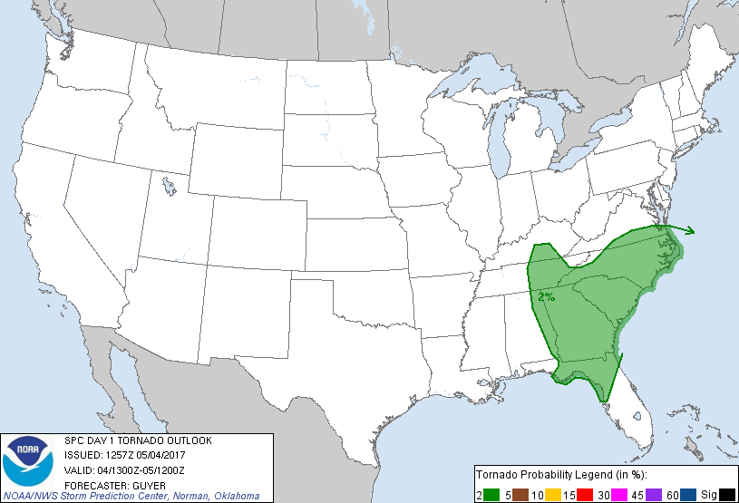
Probability of a tornado within 25 miles of a point. Hatched Area: 10% or greater probability of EF2 - EF5 tornadoes within 25 miles of a point.
Day 1 Tornado Risk
Area (sq. mi.)
Area Pop.
Some Larger Population Centers in Risk Area
2 %
209,273
32,390,094
Jacksonville, FL...Charlotte, NC...Virginia Beach, VA...Atlanta, GA...Raleigh, NC...
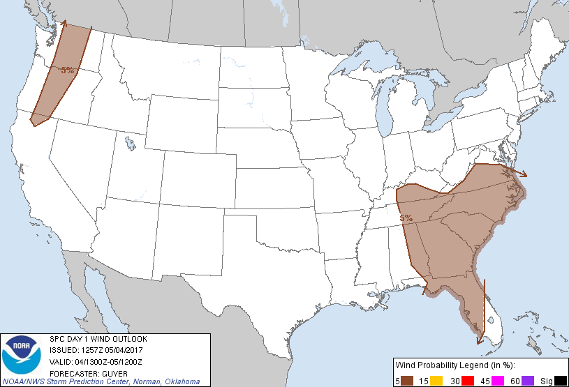
Probabilistic Damaging Wind Graphic
Probability of damaging thunderstorm winds or wind gusts of 50 knots or higher within 25 miles of a point. Hatched Area: 10% of greater probability of wind gusts 65 knots or greater within 25 miles of a point.
Day 1 Wind Risk
Area (sq. mi.)
Area Pop.
Some Larger Population Centers in Risk Area
5 %
337,330
48,028,091
Jacksonville, FL...Charlotte, NC...Nashville, TN...Virginia Beach, VA...Atlanta, GA...
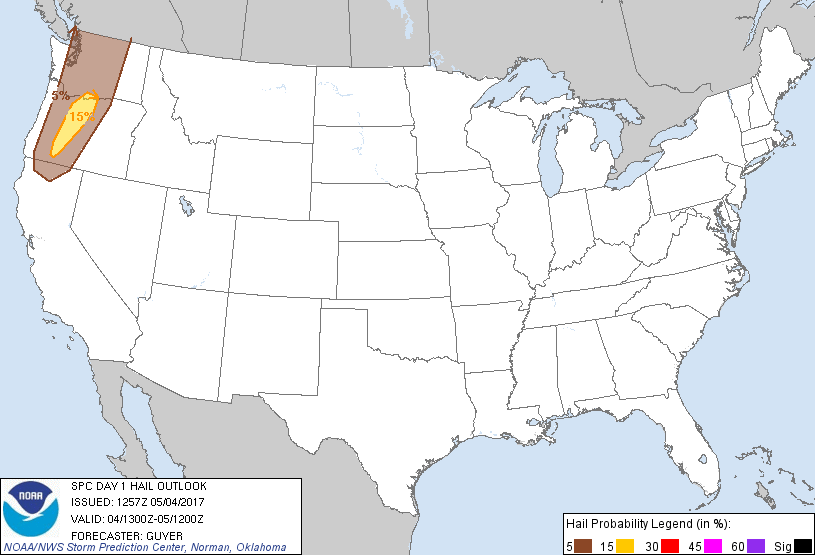
Probabilistic Large Hail Graphic
Probability of hail 1" or larger within 25 miles of a point. Hatched Area: 10% or greater probability of hail 2" or larger within 25 miles of a point.
SPC AC 041257
Day 1 Convective Outlook
NWS Storm Prediction Center Norman OK
0757 AM CDT Thu May 04 2017
Valid 041300Z - 051200Z
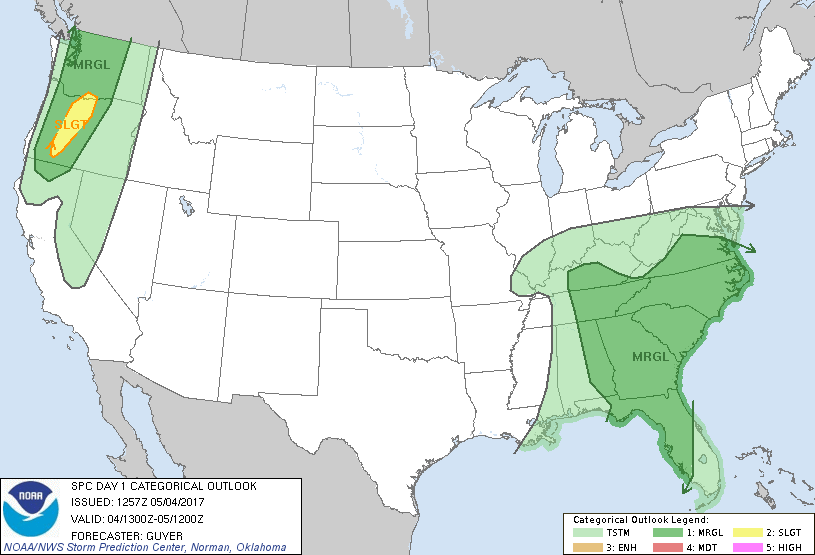
...THERE IS A SLIGHT RISK OF SEVERE THUNDERSTORMS ACROSS PORTIONS OF
THE PACIFIC NORTHWEST...
...THERE IS A MARGINAL RISK OF SEVERE THUNDERSTORMS ACROSS THE
SOUTHEAST U.S....
...THERE IS A MARGINAL RISK OF SEVERE THUNDERSTORMS ACROSS THE
PACIFIC NORTHWEST...
...SUMMARY...
Strong to severe thunderstorms will be possible today into tonight
across portions of the Pacific Northwest, in addition to the
Southeast States and Tennessee Valley to mid-Atlantic region.
...Synopsis...
A highly amplified pattern will exist over the CONUS throughout the
period. A closed trough over the Ozarks and lower/middle MS River
Valley this morning will move toward the southern
Appalachians/Southeast States through tonight and early Friday,
while an additional upper trough gradually approaches the Pacific
Northwest.
...Southeast States/Tennessee Valley to mid-Atlantic States...
The key uncertainty factor for much of the region relates to an
early-day band of outflow-focused showers and thunderstorms
extending from GA southwestward into the northeast and central Gulf
of Mexico early this morning. An extensive cloud shield is
associated with and precedes this convection, casting some
uncertainty regarding diurnal destabilization in pre-cold front
warm-sector areas. An increased confidence in thinning clouds and
somewhat more appreciable destabilization may warrant a categorical
Slight Risk upgrade in subsequent Day 1 Outlooks, potentially for
parts of GA into SC/NC.
Initially, at least some severe risk will exist early today across
the FL panhandle into other parts of north FL and south GA. For
additional short-term details, see Mesoscale Discussion 645. Even
with a cloud canopy persisting today, gradual low-level
moistening/destabilization through the afternoon could allow
outflow-focused storm development to occur into east GA and parts of
SC with at least some damaging wind/tornado risk. Other strong to
severe thunderstorms may develop this afternoon across eastern AL,
middle/eastern TN, and north GA in a north-south corridor near the
cold/occluded front.
Into this evening, it is possible that an intensification of
relatively low-topped/increasingly linear storms will gradually
occur near the east/northeastward-moving cold front, initially
across parts of GA into the Carolinas. This scenario would be aided
by a northeastward-ejecting vorticity maxima with the base of the
trough, while a surface low continues to deepen across the TN Valley
and southern Appalachians vicinity. Even with just modest
surface-based destabilization, dramatically strengthening
low/mid-level winds, accentuated by 250+ m2/s2 0-1 km SRH, will at
least conditionally support a tornado risk and/or damaging
thunderstorm winds this evening into the overnight, potentially as
far northeast as portions of NC/VA.
...Pacific Northwest...
An upper trough centered along -140W early this morning will
continue steadily eastward today, with preceding height
falls/forcing for ascent reaching the Pacific Northwest later today
and especially into tonight. With a relatively moisture-rich air
mass across the region, steep mid-level lapse rates will support
moderate destabilization across the region into mid/late afternoon.
Diurnally enhanced orographic circulations and trough-preceding
height falls/ascent will support storm development, with convection
spreading north-northeastward this afternoon and evening. The
aforementioned instability, combined with 30-45 kt of effective
shear, may support organized convective structures capable of
isolated severe hail and wind into this evening.
..Guyer.. 05/04/2017
CLICK TO GET WUUS01 PTSDY1 PRODUCT
NOTE: THE NEXT DAY 1 OUTLOOK IS SCHEDULED BY 1630Z