Indianapolis, IN...Oklahoma City, OK...Kansas City, MO...Wichita, KS...St. Louis, MO...
Probabilistic Damaging Wind Graphic
Probability of damaging thunderstorm winds or wind gusts of 50 knots or higher within 25 miles of a point. Hatched Area: 10% of greater probability of wind gusts 65 knots or greater within 25 miles of a point.
SPC AC 191253
Day 1 Convective Outlook
NWS Storm Prediction Center Norman OK
0753 AM CDT Fri May 19 2017
Valid 191300Z - 201200Z
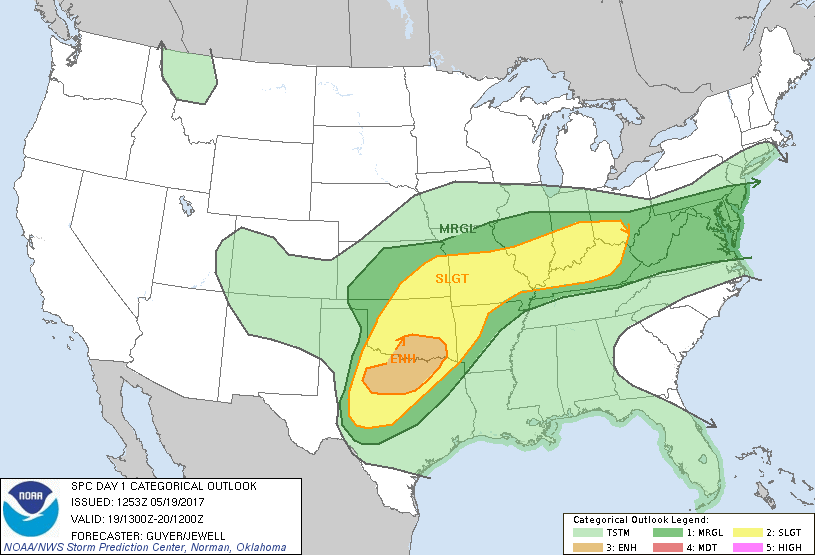
...THERE IS AN ENHANCED RISK OF SEVERE THUNDERSTORMS ACROSS NORTH
TEXAS AND SOUTHERN OKLAHOMA...
...THERE IS A SLIGHT RISK OF SEVERE THUNDERSTORMS FROM THE SOUTHERN
PLAINS TO THE OHIO VALLEY...
...THERE IS A MARGINAL RISK OF SEVERE THUNDERSTORMS FROM THE
SOUTHERN PLAINS TO THE MID-ATLANTIC STATES...
...SUMMARY...
Severe thunderstorms will be possible across parts of the southern
Plains northeastward into the Ozarks and Ohio Valley mainly this
afternoon and evening.
...Synopsis...
Within the southern stream of split westerlies over the CONUS and
Canada, a closed upper trough centered over the central and southern
Rockies early this morning will continue slowly northeastward,
reaching the central High Plains by early Saturday.
...Southern Plains to Ozarks...
The extensiveness of Thursday night's storms and related convective
overturning across parts of the region, along with additional
ongoing early-morning development, complicate the forecast scenario.
These factors cast some uncertainty regarding the location of peak
severe risk later today ahead of an east/southeastward-moving cold
front.
Strong to severe thunderstorms have been common through the
overnight within a corridor across the Low Rolling Plains of
west-central TX into western parts of north TX. These storms may
continue to grow upscale early today and persist east/northeastward
across north-central with some severe risk continuing, although the
low-level jet and related inflow should diurnally weaken. Multiple
storm-scale scenarios are plausible including diurnal eastward
persistence within a destabilizing air mass and/or a gradual morning
decay with subsequent redevelopment this afternoon across
north-central TX and south-central/southeast OK along eastern
peripheral outflow. Either scenario seems to suggest that a
semi-focused severe corridor is most evident across north-central TX
into parts of southern OK.
Farther north/northeast, details are a bit more uncertain from other
parts of OK into KS and the Ozarks region, especially considering
convectively overturned areas spanning northeast OK into MO into
northern AR (reference stability of 12Z SGF observed sounding) and
ongoing thunderstorm clusters across north TX. Nonetheless, at least
a modest degree of gradual air mass recovery/re-moistening and
destabilization is expected ahead of the east/southeastward-moving
cold front. Strengthening but somewhat backing (especially later
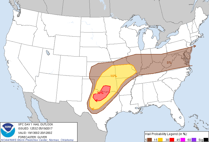
this afternoon) mid-level southwesterly winds will support some
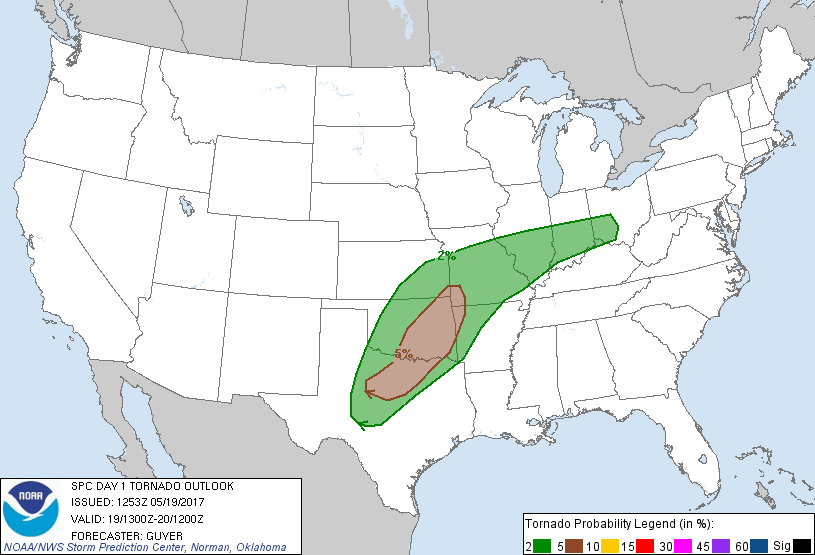
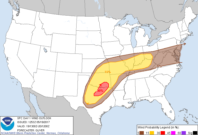
initial supercells capable of hail. At least some damaging wind risk
and tornado risk should evolve by late afternoon into evening as
low/mid-level winds increase and as storms cluster and grow upscale
within a corridor across eastern OK/southeast KS into AR and
southern MO. Spatial adjustments to the Enhanced Risk could be
warranted later today pending reassessments of the diurnal degree of
destabilization.
...Ohio Valley to central Appalachians and mid-Atlantic States...
An MCV continues to influence an east/northeastward-moving MCS
across downstate IL during the predawn hours. While the
wind-producing MCS should weaken this morning, renewed thunderstorm
intensification seems viable across the downstream lower/middle Ohio
River Valley as the MCV interacts with a southward-sagging front.
Strengthening mid-level westerlies atop the frontal zone combined
with steepening low-level lapse rates and moderate buoyancy south of
the front will support intensifying eastward-moving storm clusters
through the afternoon into evening. This includes parts of KY and
southern IN/OH eastward to the central Appalachians and downstream
mid-Atlantic region. Damaging winds gusts will be the primary risk
aside from some marginally severe hail.
..Guyer/Jewell.. 05/19/2017
CLICK TO GET WUUS01 PTSDY1 PRODUCT
NOTE: THE NEXT DAY 1 OUTLOOK IS SCHEDULED BY 1630Z