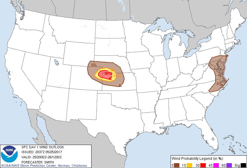
Probability of damaging thunderstorm winds or wind gusts of 50 knots or higher within 25 miles of a point. Hatched Area: 10% of greater probability of wind gusts 65 knots or greater within 25 miles of a point.
Day 1 Wind Risk
Area (sq. mi.)
Area Pop.
Some Larger Population Centers in Risk Area
30 %
12,834
61,213
No Major Population Center in Risk Area
15 %
17,418
81,187
Hays, KS...
5 %
124,376
26,406,706
Philadelphia, PA...Baltimore, MD...Denver, CO...Washington, DC...Virginia Beach, VA...
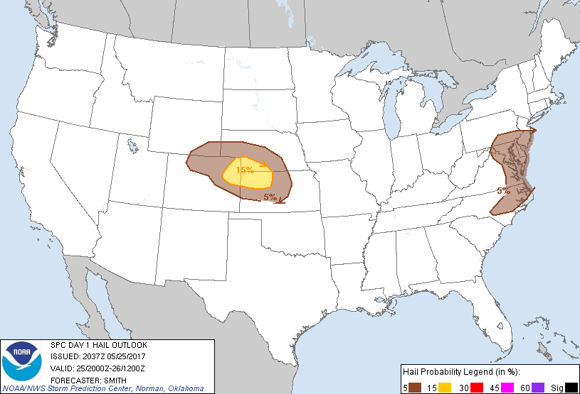
Probabilistic Large Hail Graphic
Probability of hail 1" or larger within 25 miles of a point. Hatched Area: 10% or greater probability of hail 2" or larger within 25 miles of a point.
Day 1 Hail Risk
Area (sq. mi.)
Area Pop.
Some Larger Population Centers in Risk Area
15 %
30,267
141,501
Hays, KS...
5 %
138,713
26,792,052
Philadelphia, PA...Baltimore, MD...Denver, CO...Washington, DC...Virginia Beach, VA...
SPC AC 252037
Day 1 Convective Outlook RESENT 1
NWS Storm Prediction Center Norman OK
0337 PM CDT Thu May 25 2017
Valid 252000Z - 261200Z
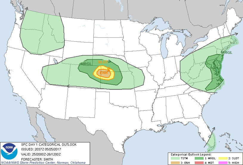
...THERE IS AN ENHANCED RISK OF SEVERE THUNDERSTORMS FOR NORTHWEST
KANSAS...FAR NORTHEASTERN COLORADO...AND FAR SOUTHWESTERN
NEBRASKA...
...THERE IS A SLIGHT RISK OF SEVERE THUNDERSTORMS SURROUNDING THE
ENHANCED RISK...
...THERE IS A MARGINAL RISK OF SEVERE THUNDERSTORMS FOR A LARGE PART
OF THE CENTRAL HIGH PLAINS...
...THERE IS A MARGINAL RISK OF SEVERE THUNDERSTORMS FOR PORTIONS OF
THE MID-ATLANTIC STATES...
...SUMMARY...
Scattered severe thunderstorms capable of severe gusts are likely
this afternoon and evening over parts of the central High Plains.
Other strong storms are possible across the Mid Atlantic Coast
region.
...Discussion...
The notable changes for this outlook update include:
1) Upgrade to 30% wind probabilities over parts of the central High
Plains. Visible satellite and radar imagery show a linear cluster
of strong/severe thunderstorms over northeastern CO near and north
of a triple point. Very steep lapse rates/evaporative cooling
coupled with organized storms will lead to a concentrated area of
severe gusts this afternoon into the early evening as the activity
moves eastward along the KS/NE border vicinity.
2) Removed low probabilities over south FL.
..Smith.. 05/25/2017
.PREV DISCUSSION... /ISSUED 1119 AM CDT Thu May 25 2017/
...Synopsis...
The elongated mid-level cold core, of large-scale upper troughing
now encompassing most areas east of the Mississippi Valley, is in
the process of pivoting northeastward across the southern Atlantic
coast states. As it continues northeastward, then northward, mostly
off the Mid Atlantic coast through the remainder of the period, the
mid Ohio Valley closed low appears likely to redevelop east
northeastward into southern New England by 12Z Friday. As it does,
an associated occluded surface low should weaken across the
mid/upper Ohio Valley, and the secondary surface low (now east
southeast of the Washington D.C./Baltimore area) may eventually
deepen near the southern New England coast.
In the wake of the short wave impulse, mid-level heights are
expected to rise, but models do suggest that mid/upper flow will
remain at least broadly cyclonic across much of the south Atlantic
Seaboard, including the Florida peninsula. It also appears that a
cold front, trailing from the Mid Atlantic surface low, may progress
through the remainder of the central and southern Florida peninsula,
before stalling and weakening.
Upstream, broad mid/upper ridging is expected to continue developing
northeastward across the southern Plains and middle/lower
Mississippi Valley, to the south of broad upper troughing
encompassing much of the northwestern U.S. into northern Plains. At
least a couple of significant perturbations are embedded within this
latter feature, including one closed low which is forecast to
gradually redevelop northeastward, across southern Saskatchewan and
Manitoba. Another closed low may form within a perturbation digging
slowly southeastward through the northern intermountain region/Great
Basin. It does appear that a weaker impulse emerging from the Great
Basin will progress east of the Colorado Rockies through much of the
north central Plains by 12Z Friday.
In response to the evolving pattern, a plume of seasonably high
moisture content has already advected southeast and east of much of
the northern Gulf of Mexico and Atlantic Seaboard (with the
exception of south Florida). However, modest moisture levels linger
beneath the lower/mid tropospheric cyclone across the Ohio Valley
and Mid Atlantic into portions of New England, ahead of a cold front
across parts of the northern Plains into Great Basin, and within lee
surface trough across the central/southern Plains. And a plume of
warm elevated mixed layer air is contributing to rather steep
mid-level lapse rates as it advects across the central/southern
Plains toward the mid/lower Mississippi Valley.
...Mid Atlantic region...
The lack of stronger vertical shear and stronger, or at least more
focused, mid-level forcing for ascent appear limiting factors
concerning severe weather potential for today. However, modest
destabilization associated with insolation and cooling aloft may
contribute to thermodynamic profiles supportive of scattered
thunderstorm activity with at least some severe wind/hail potential
(mostly marginal).
...South Florida...
Model output suggests that a weak area of low pressure may develop
near/ahead of the cold front, in the vicinity or southeast of Lake
Okeechobee, during the day today. If this occurs, locally enhanced
convergence may provide a focus for storm initiation, in the
presence of sizable CAPE and lingering strong westerly mid/upper
flow. Otherwise, weak frontal/pre-frontal low-level convergence
seems likely to limit the potential for sustained vigorous
thunderstorm development.
...Central high Plains...
A signal is evident, within the output of an ensemble of convection
allowing model guidance, that suggests sustained organized storm
development is at least possible within a corridor across parts of
northeast Colorado into northwest Kansas late this afternoon and
evening. Thermodynamic profiles across this region probably will
become favorable, with at least some further moistening beneath very
steep mid-level lapse rates. Given this environment, the deep layer
shear probably will be sufficient to enhance any convective
development. However, deterministic model output appears at least a
bit more unclear concerning supporting forcing for this activity.
As a result, severe weather potential seems largely conditional, but
perhaps enough to maintain slight risk probabilities.
CLICK TO GET WUUS01 PTSDY1 PRODUCT
NOTE: THE NEXT DAY 1 OUTLOOK IS SCHEDULED BY 0100Z