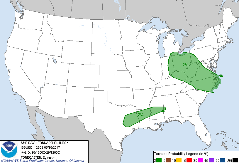
Probability of a tornado within 25 miles of a point. Hatched Area: 10% or greater probability of EF2 - EF5 tornadoes within 25 miles of a point.
Day 1 Tornado Risk
Area (sq. mi.)
Area Pop.
Some Larger Population Centers in Risk Area
2 %
238,291
36,660,447
Columbus, OH...Charlotte, NC...Cleveland, OH...Virginia Beach, VA...Raleigh, NC...
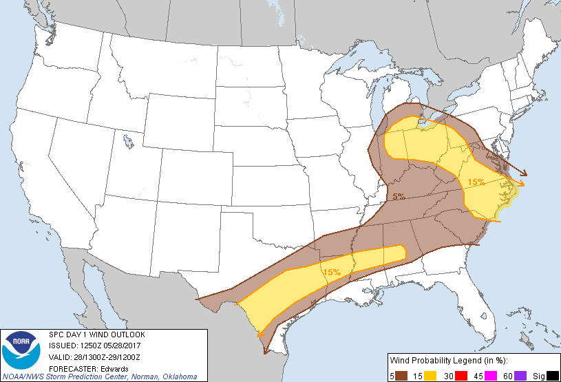
Probabilistic Damaging Wind Graphic
Probability of damaging thunderstorm winds or wind gusts of 50 knots or higher within 25 miles of a point. Hatched Area: 10% of greater probability of wind gusts 65 knots or greater within 25 miles of a point.
Day 1 Wind Risk
Area (sq. mi.)
Area Pop.
Some Larger Population Centers in Risk Area
15 %
264,727
39,540,161
San Antonio, TX...Detroit, MI...Indianapolis, IN...Columbus, OH...Austin, TX...
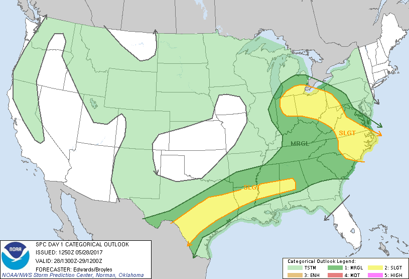
SPC AC 281250
Day 1 Convective Outlook
NWS Storm Prediction Center Norman OK
0750 AM CDT Sun May 28 2017
Valid 281300Z - 291200Z
...THERE IS A SLIGHT RISK OF SEVERE THUNDERSTORMS FROM PARTS OF
SOUTH TEXAS TO PARTS OF CENTRAL ALABAMA...
...THERE IS A SLIGHT RISK OF SEVERE THUNDERSTORMS FROM
CENTRAL/EASTERN NORTH CAROLINA TO SOUTHEASTERN LOWER MICHIGAN...
...THERE IS A MARGINAL RISK OF SEVERE THUNDERSTORMS SURROUNDING AND
BETWEEN THE SLIGHT RISKS...
...SUMMARY...
Severe thunderstorms will be possible from portions of
southern/central Texas northeastward to the lower Great Lakes and
Carolinas today. With these storms, the primary threats will be
damaging winds and large hail, although a tornado cannot be ruled
out.
...Synopsis...
Dominant features in the upper-air pattern today will include a
synoptic-scale cyclone digging southeastward from the MB/ON border
area toward Lake Superior, and longwave ridge from western MX across
the Great Basin to the Northwest Territories and beyond. A
positively tilted shortwave trough was apparent in moisture-channel
imagery south of the MB/ON cyclone, from MN to central KS and
northern NM. By 00Z, this feature is forecast to move to Lower MI,
central IL, southern MO, and northern OK. This perturbation should
weaken and accelerate eastward thereafter, its vorticity pattern
fracturing and becoming more nebulous.
At the surface, the 11Z analysis showed a warm front over central OH
to a weak low over north-central IN, then cold front southwestward
across the Ozarks, southeastern OK, the Edwards Plateau and far west
TX. The low should move slowly east-northeastward across
northwestern OH through 00Z, with the front reaching southern IN,
central AR, and south-central TX. By 12Z, the front should be
located over western NY, western TN and southeast TX, becoming weak
and quasistationary along much of that stretch. A prefrontal,
composite outflow boundary from several convective systems is very
well-defined this morning from northern GA across central parts of
MS/AL, northern LA, and parts of east TX. This boundary should
decelerate during the next few hours as reinforcing convection
weakens and moves away. The boundary may retreat slightly northward
on the mesoscale through late afternoon.
...Lower Mississippi Valley to south TX...
Considerable stabilization has occurred north of an aggregate of
outflow boundaries from northern GA to northern LA that may move
somewhat further south before stalling late morning into midday.
Trailing precip/clouds are expected to linger through much of the
morning, greatly impeding diurnal destabilization with northward
extent from the outflow edge. As such, affected parts of the
earlier outlook area have been reconfigured.
Scattered thunderstorms are expected to develop this afternoon near
the cold front and residual outflow/differential-heating boundaries.
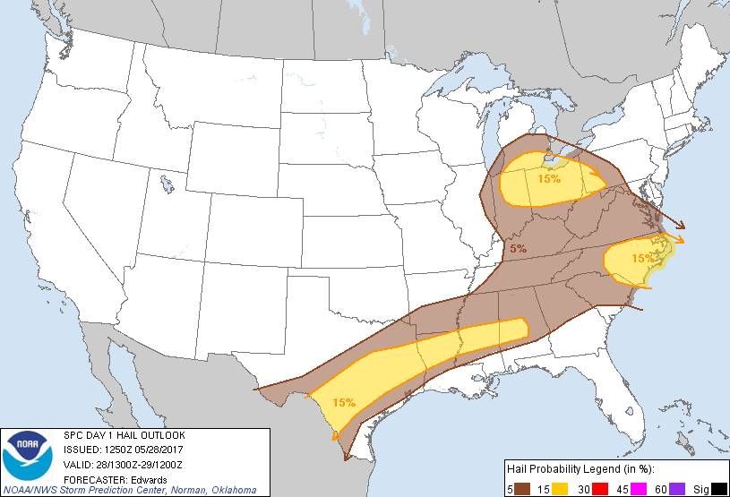
The main threats will be damaging wind and sporadic large hail.
The boundary layer south of the front and outflows will be
characterized by rich moisture, with mean mixing ratios of 17-19
g/kg and surface dew points generally in the mid 70s F. Midlevel
lapse rates will steepen with westward extent into a progressively
better-defined EML, combining with strong surface heating this
afternoon to yield MLCAPE ranging from around 2500 J/kg over
central/southern AL to around 4500 J/kg in parts of south TX. Flow
just south of the combined front/outflow zone, surface and aloft,
will be nearly parallel to the combined boundary, contributing to
quick evolution from initial multicellular/marginally supercellular
phases into a messy, quasi-linear mode with embedded severe
clusters. The veered surface winds also will temper both low-level
and deep shear, with forecast soundings showing effective-shear
magnitudes less than 35 kt. As such, multicell modes should
dominate. The severe threat will become more fragmented through the
evening and diminish with time as the near-surface layer slowly
cools/stabilizes.
...Eastern NC to Great Lakes...
Widely scattered to scattered thunderstorms are expected to develop
this afternoon across this swath, offering occasional damaging gusts
and large hail.
Activity will be supported by residual low-level moisture ahead of
the surface cold front, lift from the front and possibly prefrontal
convergence lines, large-scale DCVA/destabilization aloft ahead of
the approaching shortwave trough (in the Great Lakes region), and
elimination of most MLCINH via surface diabatic heating. Lapse
rates aloft will increase with northwestward extent under cooler
mid/upper level temps, but boundary-layer lapse rates and moisture
will be greater over and east of the Piedmont. MLCAPE should peak
between 500-1000 J/kg on the Great Lakes lobe of the outlook, amidst
modest effective-shear magnitudes generally less than 35 kt, and
nearly straight hodographs. Farther southeast into NC, 1000-2000
J/kg MLCAPE should prevail, locally higher, with surface dew points
commonly in the mid 60s to low 70s F.
..Edwards/Broyles.. 05/28/2017
CLICK TO GET WUUS01 PTSDY1 PRODUCT
NOTE: THE NEXT DAY 1 OUTLOOK IS SCHEDULED BY 1630Z