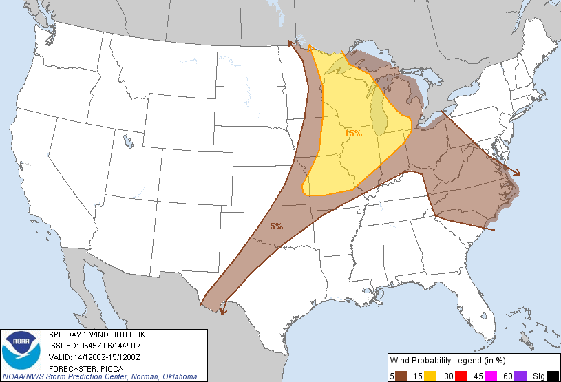
Probability of damaging thunderstorm winds or wind gusts of 50 knots or higher within 25 miles of a point. Hatched Area: 10% of greater probability of wind gusts 65 knots or greater within 25 miles of a point.
Day 1 Wind Risk
Area (sq. mi.)
Area Pop.
Some Larger Population Centers in Risk Area
15 %
246,146
31,197,653
Chicago, IL...Milwaukee, WI...Kansas City, MO...St. Louis, MO...Fort Wayne, IN...
5 %
490,586
59,101,792
Detroit, MI...Indianapolis, IN...Columbus, OH...Charlotte, NC...Oklahoma City, OK...
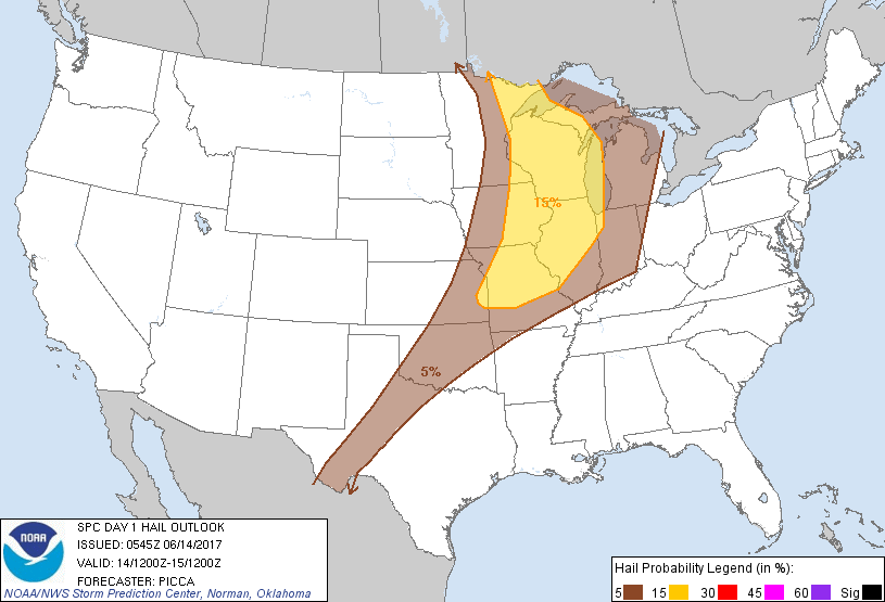
Probabilistic Large Hail Graphic
Probability of hail 1" or larger within 25 miles of a point. Hatched Area: 10% or greater probability of hail 2" or larger within 25 miles of a point.
Day 1 Hail Risk
Area (sq. mi.)
Area Pop.
Some Larger Population Centers in Risk Area
15 %
205,291
25,324,179
Chicago, IL...Milwaukee, WI...Kansas City, MO...St. Louis, MO...Madison, WI...
5 %
323,149
24,511,682
Indianapolis, IN...Oklahoma City, OK...Tulsa, OK...Minneapolis, MN...Wichita, KS...
SPC AC 140545
Day 1 Convective Outlook
NWS Storm Prediction Center Norman OK
1245 AM CDT Wed Jun 14 2017
Valid 141200Z - 151200Z
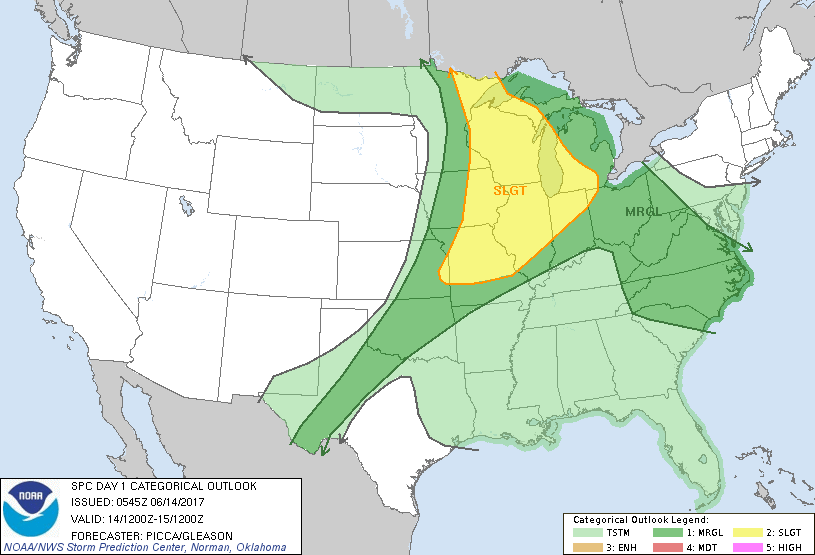
...THERE IS A SLIGHT RISK OF SEVERE THUNDERSTORMS FROM THE UPPER
GREAT LAKES TO THE LOWER MISSOURI VALLEY...
...THERE IS A MARGINAL RISK OF SEVERE THUNDERSTORMS FROM WEST TEXAS
TO THE UPPER OHIO VALLEY AND CAROLINAS...
...SUMMARY...
Clusters of strong to severe thunderstorms are expected this
afternoon and evening across parts of the Upper Great Lakes
southward to the lower Missouri Valley. The primary threats with
these storms will be damaging wind gusts and large hail. Elsewhere,
isolated strong/severe storms will be possible across the southern
Plains, Ohio Valley, and the Carolinas.
...Synopsis...
A closed mid-level low will lift into southern Saskatchewan/Manitoba
today, as it becomes more vertically stacked and the attendant
surface low gradually occludes later in the period. Meanwhile, along
the southern periphery of broad cyclonic flow, a series of impulses,
likely convectively augmented, will advance eastward towards the
Mississippi Valley this afternoon. In their wake, broad/modest
westerly mid-level flow will establish across much of the western
US. Farther downstream, several weak perturbations will meander
slowly across the Appalachians and Southeast US, as they persist
within a weak-flow environment.
...Upper Great Lakes to the Missouri Valley...
The severe threat today may be tempered some by residual cloud
cover/stabilization from overnight/early morning lingering
convection. Nonetheless, pockets of heating (especially with
southward extent) and a layer of steep mid-level lapse rates will
promote sufficient destabilization by afternoon, with MLCAPE values
potentially upwards of 2000-3000 J/kg. Outflow boundaries and/or
weak MCVs emanating from overnight convection will likely support
convective re-development by mid-day/early afternoon across parts of
Wisconsin and Illinois. While deep-layer shear will not be
particularly impressive, dry mid-level air atop a warm/moist
boundary layer will favor strong downdraft momentum. In turn,
convection may grow upscale into small clusters/bowing segments as
they push east towards Indiana and Michigan, with a primary threat
of damaging wind. Aided by weak impulses aloft, clusters of
convection may also organize along remnant outflow across parts of
the lower Missouri Valley. Initial development may be capable of
severe hail, with the overall threat transitioning to strong,
damaging winds through the late afternoon and evening.
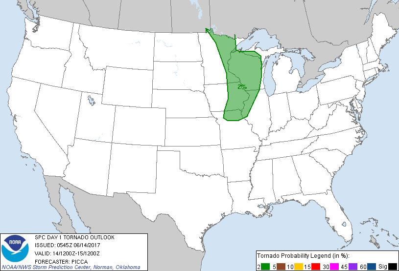
Farther north, instability will be less, but mid-level flow and
effective shear will be considerably stronger. In turn, more
vigorous convection that can develop near/ahead of the cold front
during the afternoon will be capable of occasional mid-level
rotation, increasing the threat of large hail. Moreover, some
directional and speed shear in the lowest 1-3 km may support a
tornado or two. However, complex storm interactions/evolution from
meridional upper-level flow (in addition to concerns regarding
boundary-layer destabilization) cast doubt upon a higher tornadic
potential.
...Oklahoma and Texas...
Large-scale ascent will not be particularly strong through the
period, but ample heating amidst steep mid-level lapse rates will
encourage MLCAPE values upwards of 3000 J/kg. Convective inhibition
will likely keep storms sparse, especially across parts of Oklahoma,
but adequate westerly mid/upper flow and favorable veering of winds
with height may sustain a few stronger updrafts. In turn, a few
instances of large hail and damaging winds appear possible during
the evening and early overnight hours.
...Ohio Valley to the Carolinas...
Encouraged by weak shortwave troughs meandering across the region,
diurnal convection will blossom through the early/mid afternoon.
Mid-level flow will be quite weak, such that storm propagation will
be driven by cold pools (and enhanced by mergers). A moist,
well-mixed boundary layer will enable strong, locally damaging gusts
before storms weaken later in the day.
..Picca/Gleason.. 06/14/2017
CLICK TO GET WUUS01 PTSDY1 PRODUCT
NOTE: THE NEXT DAY 1 OUTLOOK IS SCHEDULED BY 1300Z