The SPC is forecasting ...Severe thunderstorms expected over parts of the central Plains this afternoon and evening....
Please read
the latest public statement about this event. View What is a Watch? clip.
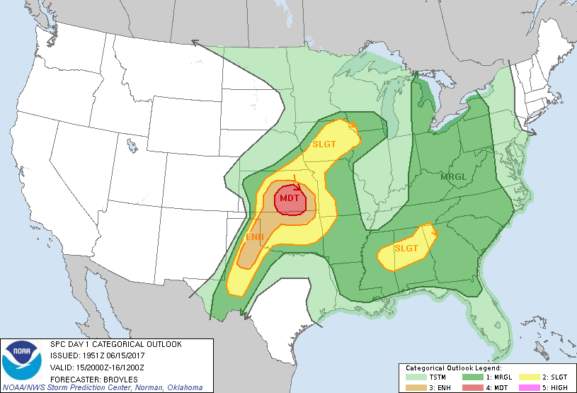
Categorical Graphic
Day 1 Risk
Area (sq. mi.)
Area Pop.
Some Larger Population Centers in Risk Area
MODERATE
19,918
952,746
Wichita, KS...Salina, KS...Hutchinson, KS...Emporia, KS...Ponca City, OK...
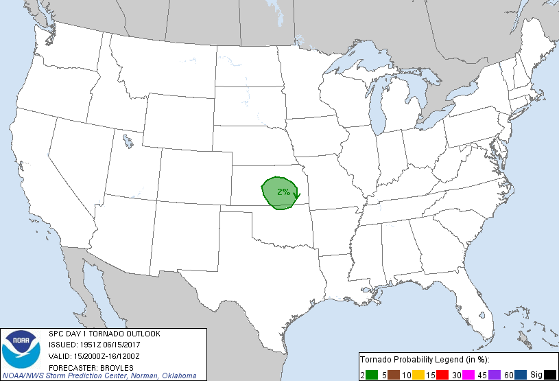
Probability of a tornado within 25 miles of a point. Hatched Area: 10% or greater probability of EF2 - EF5 tornadoes within 25 miles of a point.
Day 1 Tornado Risk
Area (sq. mi.)
Area Pop.
Some Larger Population Centers in Risk Area
2 %
23,996
1,059,234
Wichita, KS...Salina, KS...Hutchinson, KS...Emporia, KS...Ponca City, OK...
Probabilistic Damaging Wind Graphic
Probability of damaging thunderstorm winds or wind gusts of 50 knots or higher within 25 miles of a point. Hatched Area: 10% of greater probability of wind gusts 65 knots or greater within 25 miles of a point.
Day 1 Wind Risk
Area (sq. mi.)
Area Pop.
Some Larger Population Centers in Risk Area
SIG SEVERE
26,111
1,121,008
Wichita, KS...Salina, KS...Hutchinson, KS...Emporia, KS...Ponca City, OK...
45 %
19,918
952,746
Wichita, KS...Salina, KS...Hutchinson, KS...Emporia, KS...Ponca City, OK...
   SPC AC 151951

   Day 1 Convective Outlook
   NWS Storm Prediction Center Norman OK
   0251 PM CDT Thu Jun 15 2017

   Valid 152000Z - 161200Z

   ...THERE IS A MODERATE RISK OF SEVERE THUNDERSTORMS ACROSS PARTS OF
   CENTRAL AND SOUTHEAST KANSAS INTO FAR NORTHERN OKLAHOMA...

   ...THERE IS AN ENHANCED RISK OF SEVERE THUNDERSTORMS ACROSS PARTS OF
   THE SOUTHERN AND CENTRAL PLAINS...

   ...THERE IS A SLIGHT RISK OF SEVERE THUNDERSTORMS ACROSS PARTS OF
   THE SOUTHERN AND CENTRAL PLAINS...WESTERN OZARKS...MID MISSOURI
   VALLEY AND UPPER MISSISSIPPI VALLEY...

   ...THERE IS A SLIGHT RISK OF SEVERE THUNDERSTORMS ACROSS PARTS OF
   MISSISSIPPI...ALABAMA AND NORTHWEST GEORGIA...

   ...THERE IS A MARGINAL RISK OF SEVERE THUNDERSTORMS ACROSS PARS OF
   THE SOUTHERN AND CENTRAL PLAINS...OZARKS...MISSISSIPPI VALLEY...GULF
   COAST STATES...SOUTHERN AND CENTRAL APPALACHIANS...OHIO VALLEY AND
   EASTERN GREAT LAKES...

   ...SUMMARY...
   Widespread severe and potentially destructive winds are forecast to
   accompany thunderstorms across parts of central, southern, and
   eastern Kansas into northern Oklahoma this afternoon into the
   evening. Severe storms with hail and wind will also be possible
   across a broad area from parts of West Texas to the upper
   Mississippi Valley, eastward to the Great Lakes region to the
   Southeast.

   A few changes have been made to the outlook for this issuance. The
   first change is to extend the slight south-southwestward across
   parts of west Texas. Thunderstorms are expected to develop late this
   afternoon in the vicinity of Midland, TX and move east-southeastward
   to near San Angelo by early evening. Strong instability and moderate
   deep-layer shear evident on RAP analysis should be sufficient for
   isolated large hail and wind damage...see MCD 1041. The second
   change to the outlook is to trim the slight risk area behind a
   convective line situated in northern Mississippi and northern
   Alabama. The western part of this slight risk area has also been
   trimmed across western Mississippi where convection has been
   struggling this afternoon. The third change to the outlook is to add
   parts of western Kansas into the marginal risk area where moderate
   instability is located. This environment could support hail and
   strong wind gusts if a cell can initiate that far west.

   ..Broyles.. 06/15/2017

   .PREV DISCUSSION... /ISSUED 1128 AM CDT Thu Jun 15 2017/

   ...Central/southern/eastern KS into northern OK...
   Confidence is increasing that supercell development will occur near
   a surface cyclone near/west of the Hays and Hill City KS area in the
   1900-2030Z time frame. Mesoscale convergence will be enhanced near
   this cyclone, marking the approximate intersection of a synoptic
   boundary extending northeastward and a residual outflow boundary
   extending southeastward. Anticipated MLCAPE around 3000-4500 J/kg,
   and little residual capping by mid afternoon on the periphery of a
   midlevel speed maximum, suggest that a cluster of intense updrafts
   will likely evolve with strong outflow winds supported by DCAPE
   around 1500 J/kg.

   Severe hail -- possibly significant -- may accompany incipient
   updrafts. Coalescing outflow should quickly support upscale
   convective growth, with this activity organizing into one or two
   forward propagating MCSs, with leading convective lines exhibiting
   marked bowing characteristics amid 30-40 kt of effective shear.
   Preferential cell development into the high theta-e air south of the
   synoptic boundary will encourage southward propagation, with
   eastward midlevel flow encouraging elongating cold pools/forward
   propagation to the east. This will translate to MCS activity
   spreading into parts of northern OK and eastern/southern KS through
   the evening hours. The latest observational data and CAM guidance
   offer increasing support in a focused corridor of bowing MCSs with
   the likelihood of severe winds -- including significant severe winds
   -- warranting upgrade to Moderate Risk.

   Southeastward spread of the MCSs will likely persist into the
   evening/overnight from parts of central/eastern OK toward western
   parts of the Ozarks, though this activity will weaken as outflow
   outpaces parent convection and inflow static stability increases
   nocturnally.

   ...West Texas into western OK...
   A diurnally sharpening dryline will be the focus for storm
   development this afternoon. Steep midlevel lapse rates support very
   strong buoyancy, and long mid/high-level hodographs suggest that
   severe hail -- some significantly severe -- may accompany this
   activity. The Enhanced area has been extended southwestward.

   ...IA vicinity...
   Southeast of the aforementioned synoptic boundary that will extend
   northeastward into the upper Mississippi Valley, strong instability
   and relatively long midlevel hodographs suggest that splitting
   storms and convective clusters may occur as a large-scale ascent is
   enhanced around a midlevel speed maximum. Isolated to widely
   scattered severe potential will exist with this activity into the
   overnight hours as activity spreads toward the Chicago area.

   ...Lower Mississippi Valley to the TN Valley region...
   Relatively steep midlevel lapse rates above a moist boundary layer
   will support ample instability/DCAPE for widely scattered damaging
   wind potential with storm clusters intensifying along/ahead of a
   southward-advancing outflow boundary. The greatest severe risk will
   extend from the ArkLaMiss region to northwest GA where the greatest
   destabilization is anticipated ahead of the outflow boundary.

   ...Great Lakes region to the Southeast surrounding the lower
   Mississippi Valley/TN Valley vicinity Slight Risk...
   Isolated severe wind/hail may accompany generally pulse convection
   through the early evening. Weak deep shear amid relatively weaker
   midlevel lapse rates, and/or less organized antecedent cold-pool
   formation, should limit severe coverage.

   CLICK TO GET WUUS01 PTSDY1 PRODUCT

   NOTE: THE NEXT DAY 1 OUTLOOK IS SCHEDULED BY 0100Z