Probability of damaging thunderstorm winds or wind gusts of 50 knots or higher within 25 miles of a point. Hatched Area: 10% of greater probability of wind gusts 65 knots or greater within 25 miles of a point.
Day 1 Wind Risk
Area (sq. mi.)
Area Pop.
Some Larger Population Centers in Risk Area
15 %
27,749
253,880
Garden City, KS...Dodge City, KS...Liberal, KS...Hays, KS...
SPC AC 201258
Day 1 Convective Outlook
NWS Storm Prediction Center Norman OK
0758 AM CDT Tue Jun 20 2017
Valid 201300Z - 211200Z
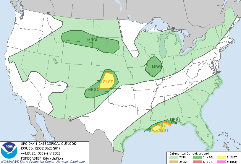
...THERE IS A SLIGHT RISK OF SEVERE THUNDERSTORMS MAINLY OVER
WESTERN KANSAS...
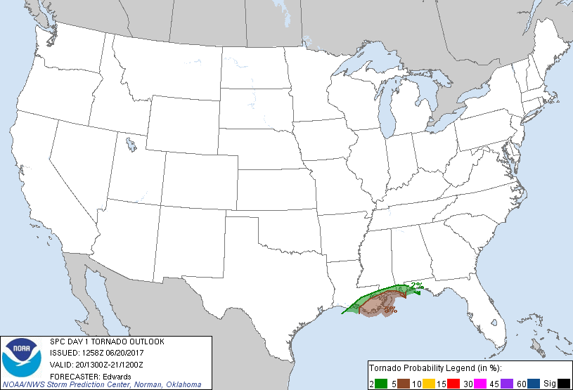
...THERE IS A SLIGHT RISK OF SEVERE THUNDERSTORMS FOR
TORNADOES...FROM SOUTHEASTERN LOUISIANA ALONG PARTS OF THE
MISSISSIPPI/ALABAMA COAST...
...THERE IS A MARGINAL RISK OF SEVERE THUNDERSTORMS SURROUNDING THE
CENTRAL PLAINS SLIGHT RISK...
...THERE IS A MARGINAL RISK OF SEVERE THUNDERSTORMS SURROUNDING THE
GULF COAST SLIGHT RISK...
...THERE IS A MARGINAL RISK OF SEVERE THUNDERSTORMS FROM PARTS OF
NORTHERN WYOMING AND SOUTHERN MONTANA TO SOUTH DAKOTA...
...THERE IS A MARGINAL RISK OF SEVERE THUNDERSTORMS OVER PARTS OF
ILLINOIS...
...SUMMARY...
Severe thunderstorms are expected this afternoon and evening over
parts of the central High Plains. A tornado risk will develop this
afternoon and remain through tonight over the central Gulf Coast.
Isolated severe storms also are possible over parts of Illinois and
the mid Mississippi Valley, as well as from the northern Rockies and
High Plains into South Dakota.
...Synopsis...
The upper-air pattern will be characterized by three primary/
synoptic features through the period:
1. Broadly cyclonic flow from the Upper Midwest across the Great
Lakes and Ohio Valley to New England. A series of low-amplitude
shortwaves will traverse that flow field and help to maintain mean
troughing through the period, before heights rise on day 2. One of
these perturbations -- currently located over western Lake Superior
and northern MN -- will dig southeastward to lower MI and northern/
western IL by 00Z.
2. An intense anticyclone anchored over AZ, with ridging eastward
across the Red River region, through a col over MS/AL, connecting to
the Atlantic subtropical ridge.
3. A fetch of fast, nearly zonal, northern-stream flow across the
Pacific Northwest, southwestern Canada and northern Rockies,
containing shortwaves ejecting from the base of a cyclone over the
Gulf of Alaska. One of these perturbations -- now evident in
moisture-channel imagery approaching the west-central/southwest
coast of BC -- is forecast to reach the Canadian Rockies along the
BC/AB border around 00Z, then eject east-northeastward to SK
overnight.
At the surface, 11Z analysis showed a cold front from central QC
southward across southeastern NY and eastern VA, becoming
quasistationary southwestward over the southern Appalachians to
northern LA and north-central TX, then a warm front to a weak low
over southeastern CO. Frontolysis is expected along most of this
boundary throughout the period. Meanwhile, another cold front was
analyzed from eastern Lake Superior across western WI, southern MN,
and west-central SD, into southeastern MT. The SD/MT segment of
this front will decelerate/stall today, while the remainder proceeds
southeastward across portions of the upper Great lakes and mid/upper
Mississippi Valley. A weak front/trough will move slowly
southeastward across parts of southern NE and northern KS,
intersecting a lee trough in eastern CO.
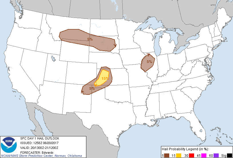
...Central High Plains...
Scattered to widely scattered thunderstorms should develop this
afternoon near the weak front/trough over northern/western KS, with
isolated, shorter-lived convection possible southwestward to
northeastern NM moving off the Raton Mesa region. The greatest
concentration should be over the KS part of the outlook area, with
initial multicellular and perhaps messy supercellular modes growing
upscale into a southward- to southeastward-moving, cold-pool-driven
complex offering damaging wind.
Activity will develop in an environment of seasonally hot/well-mixed
boundary layers, increasing low-level moisture accompanying the
retreating/weakening warm front, and diabatically minimized MLCINH,
beneath steep midlevel lapse rates. Forecast soundings depict
preconvective MLCAPE 2000-4000 J/kg, amidst 40-50-kt effective-shear
magnitudes. While low-level flow will remain modest, considerable
veering of flow with height will contribute to the favorable deep
shear. It is uncertain how far south and southeast any resulting
MCS will propagate before weakening to severe levels; however, the
outlook area has been expanded somewhat eastward and southward to
account for possible evening/early-overnight penetration of damaging
gusts through a shallow near-surface stable layer.
...Central Gulf Coast...
Potential Tropical Cyclone Three (PTC3 for short) is forecast by NHC
to move generally northwestward across the central and northwestern
Gulf through the period. That motion, combined with the decidedly
asymmetric nature of PTC3 (per forecast NHC wind radii) should
spread a broad area of strengthening low-level winds in the
northeastern quadrant over the outlook area, just above the surface.
This will result in steadily enlarging hodographs through the
period, within which any embedded, sustained convective elements may
have an increasing potential to rotate. Some uncertainties exist
regarding local storm modes within the typically favored sector of
PTC3's envelope, given
1. Impacts on destabilization from the expansive cloud/precip
shield, and
2. Possible subtropical (instead of tropical) evolution of the
system as discussed by NHC, which would impact kinematic and
convective character.
Still, the most favorable parameter space for tornado potential
appears to be over parts of southeastern LA and parts of the
immediate MS/AL coastal areas from this afternoon through tonight.
Outer bands and perhaps discrete cells may move inland amidst weak
buoyancy (MLCAPE 200-500 J/kg) and 0-1-km SRH strengthening above
300 J/kg.
Refer to the latest NHC advisories for forecast track/intensity and
watch/warning information related to PTC3.
...MT/WY to SD...
Widely scattered thunderstorms may develop over western parts of the
region this afternoon, moving rapidly eastward to east-southeastward
across the outlook area through overnight hours. Isolated damaging
wind and large hail are possible during the afternoon and evening
over the northern Rockies/northern High Plains part of the outlook
area, transitioning to an isolated hail threat late overnight in SD.
Large-scale lift preceding the northern-stream shortwave trough,
combined with diabatic heating of higher terrain, will steepen
deep-layer lapse rates across this region in the presence of at
least marginal low-level moisture. Resulting convection will move
over well-mixed subcloud layers supporting the potential for
momentum transfer to surface and strong/locally severe gusts.
Favorable deep shear for isolated large hail also is apparent in
forecast soundings. Lack of more robust low-level moisture will
preclude a greater unconditional severe threat.
Overnight, a southerly, 30-45-kt LLJ over the central Plains is
expected to increase theta-e above the surface, and potentially in
inflow parcels available to convection moving east-southeastward to
eastward over SD. This may be in the form of new elevated
development rooted near 700 mb or extension/ rejuvenation of earlier
storms moving out of MT/WY. Hail and strong gusts each are
possible, given the presence of dry air below the storm-inflow
region, though the gust potential should be mitigated to a
considerable extent by diabatically stabilized near-surface air.
...IL, mid Mississippi Valley...
Widely scattered to scattered thunderstorms are expected to
intensify and move southeastward from midday through late afternoon
across this area, offering sporadic hail/gusts near severe levels.
Activity is expected to develop near and ahead of the cold front,
and in a zone of large-scale lift/cooling aloft preceding the
shortwave trough, each impinging on a diabatically destabilized
boundary layer and related increase in low-level buoyancy. Despite
a "CAPE robber" layer of relatively warm air around 500 mb, forecast
soundings suggest favorable low-level parcel accelerations amidst
steep low/middle-level lapse rates, and a well-mixed subcloud layer.
MLCAPE potentially topping 1000 J/kg (commonly above 500 J/kg), and
effective-shear magnitudes 50-60 kt, indicate the potential for
organized storm modes including a few supercells with mainly hail
risk early, perhaps transitioning upscale to quasi-linear segments
and bows with time. The severe threat should lessen through evening
as the near-surface layer cools. Lack of greater low-level moisture
will preclude a more robust severe threat.
..Edwards/Picca.. 06/20/2017
CLICK TO GET WUUS01 PTSDY1 PRODUCT
NOTE: THE NEXT DAY 1 OUTLOOK IS SCHEDULED BY 1630Z