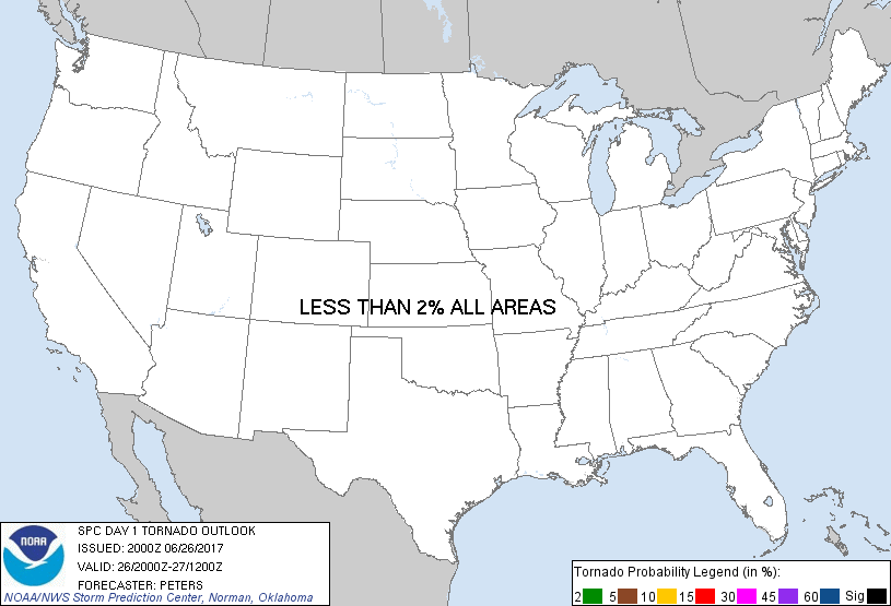
Probability of a tornado within 25 miles of a point. Hatched Area: 10% or greater probability of EF2 - EF5 tornadoes within 25 miles of a point.
Day 1 Tornado Risk
Area (sq. mi.)
Area Pop.
Some Larger Population Centers in Risk Area
No Risk Areas Forecast
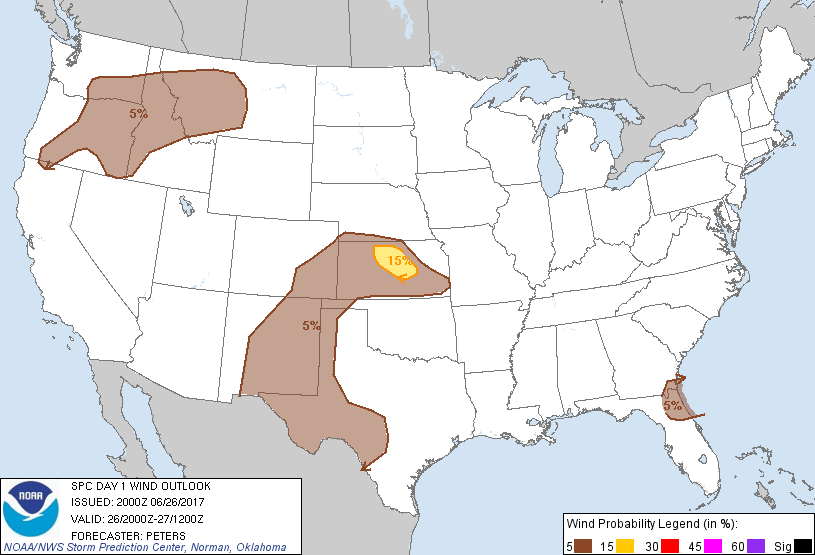
Probabilistic Damaging Wind Graphic
Probability of damaging thunderstorm winds or wind gusts of 50 knots or higher within 25 miles of a point. Hatched Area: 10% of greater probability of wind gusts 65 knots or greater within 25 miles of a point.
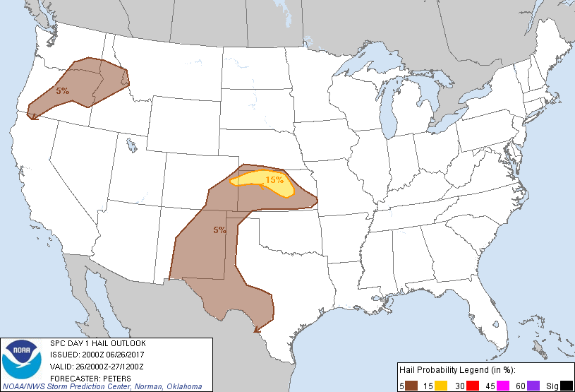
Probability of hail 1" or larger within 25 miles of a point. Hatched Area: 10% or greater probability of hail 2" or larger within 25 miles of a point.
Day 1 Hail Risk
Area (sq. mi.)
Area Pop.
Some Larger Population Centers in Risk Area
15 %
24,009
287,262
Salina, KS...Hays, KS...Newton, KS...
5 %
318,607
5,940,829
El Paso, TX...Albuquerque, NM...Wichita, KS...Pueblo, CO...Midland, TX...
SPC AC 262000
Day 1 Convective Outlook
NWS Storm Prediction Center Norman OK
0300 PM CDT Mon Jun 26 2017
Valid 262000Z - 271200Z
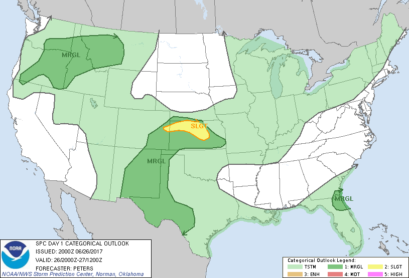
...THERE IS A SLIGHT RISK OF SEVERE THUNDERSTORMS ACROSS PART OF
NORTHERN AND CENTRAL KANSAS INTO A SMALL PART OF EASTERN COLORADO...
...THERE IS A MARGINAL RISK OF SEVERE THUNDERSTORMS SURROUNDING THE
SLIGHT RISK AREA IN THE CENTRAL TO SOUTHERN PLAINS...
...THERE IS A MARGINAL RISK OF SEVERE THUNDERSTORMS ACROSS THE
PACIFIC NORTHWEST AND NORTHERN ROCKIES...
...THERE IS A MARGINAL RISK OF SEVERE THUNDERSTORMS ACROSS NORTHERN
FL AND SOUTHEAST GA...
...SUMMARY...
Thunderstorms with severe hail and strong wind gusts are possible
late this afternoon into evening across the Pacific Northwest and
Northern Rockies in addition to parts of the Great Plains. Other
strong storms may occur along the coastal southeast States.
...Eastern CO/southwest NE/northern and central KS...
Trends in visible satellite imagery and mosaic radar imagery showed
some increase in thunderstorm development across far southern NE
into northern KS and eastern CO. Given the presence of moderate
instability and effective bulk shear of 30-40 kt, additional
organized storms appear a concern through the afternoon into the
evening. Last several runs of the HRRR suggest a greater clustering
of storms may occur from northern KS to the south-southeast reaching
the Wichita, KS area this evening. This outlook has increased the
severe hail and damaging wind probabilities resulting in a Slight
risk area in parts of KS to eastern CO. For additional short-term
guidance, refer to mesoscale discussion 1152.
...Part of south-central WA...
Given ongoing convection and some thunderstorms developing in lee of
the southern WA Cascades, steep low-level lapse rates and DCAPE
exceeding 1000 J/kg suggest locally strong wind gusts will be
possible. This outlook has expanded the marginal severe wind threat
westward some to include more of south-central WA.
..Peters.. 06/26/2017
.PREV DISCUSSION... /ISSUED 1144 AM CDT Mon Jun 26 2017/
...Pacific Northwest/northern Rockies...
Gradually strengthening westerlies aloft are expected over the
region today. This will be as an upper low just off the coast of
northern CA continues east-northeastward and a trough amplifies over
British Columbia, while a convectively related disturbance also
shifts eastward from southeast WA/northern ID into MT. It seems
likely that thunderstorms will increase this afternoon especially
east of the Cascades across central/eastern OR into adjacent
ID/southeast WA, in addition to parts of west-central MT.
Strengthening winds aloft/vertical shear will help support some
sustained east/northeastward-moving storms. Isolated instances of
locally damaging winds will be possible with the strongest storms
along with some hail, particularly across parts of OR into ID where
somewhat greater moisture/destabilization is expected.
...Central Plains/southern High Plains...
Under the glancing influence of the Upper Midwest/Great Lakes
upper-level trough, isolated to widely scattered thunderstorms are
likely to develop by mid/late afternoon within a corridor from
southern NE southward into KS. Although mid-level lapse rates are
not particularly steep by late-June standards, gradually returning
moisture, moderate buoyancy, and supercell-favorable wind profiles
(in the presence of strong northwesterly flow aloft) should allow
for isolated severe thunderstorms capable of severe hail/locally
damaging winds as these storms spread southeastward through the late
afternoon and evening hours.
Elsewhere, as a moist upslope flow regime persists, other storms are
likely to develop/intensify across along the southeast CO/northeast
NM Raton Mesa vicinity and higher terrain of interior NM. In the
presence of moderate buoyancy and 30-35 kt of effective shear, some
of the stronger storms will be capable of hail.
Farther south, one or more remnant MCVs may refocus afternoon
redevelopment, including the possibility of a few stronger storms,
across parts of the TX Edwards Plateau and nearby Transpecos
vicinity.
...North FL/coastal GA...
As weak height falls spread toward the region today, a moist
environment and sea breeze circulations in vicinity of a
stalled/slow-moving front may allow for a few stronger storms this
afternoon capable of downbursts.
CLICK TO GET WUUS01 PTSDY1 PRODUCT
NOTE: THE NEXT DAY 1 OUTLOOK IS SCHEDULED BY 0100Z