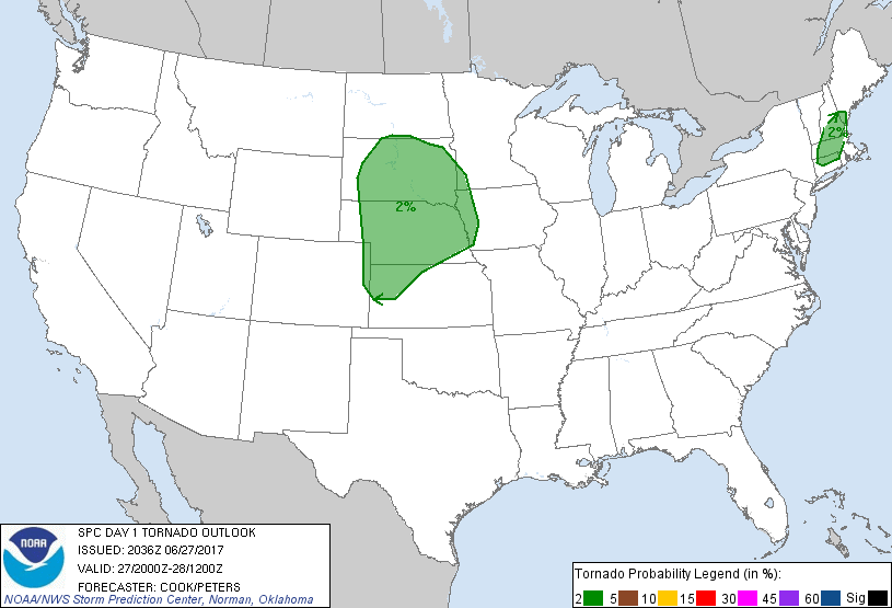
Probability of a tornado within 25 miles of a point. Hatched Area: 10% or greater probability of EF2 - EF5 tornadoes within 25 miles of a point.
Day 1 Tornado Risk
Area (sq. mi.)
Area Pop.
Some Larger Population Centers in Risk Area
2 %
164,030
7,736,020
Omaha, NE...Lincoln, NE...Worcester, MA...Springfield, MA...Sioux Falls, SD...
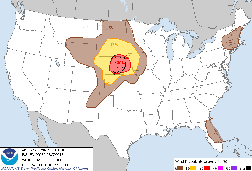
Probabilistic Damaging Wind Graphic
Probability of damaging thunderstorm winds or wind gusts of 50 knots or higher within 25 miles of a point. Hatched Area: 10% of greater probability of wind gusts 65 knots or greater within 25 miles of a point.
Day 1 Wind Risk
Area (sq. mi.)
Area Pop.
Some Larger Population Centers in Risk Area
SIG SEVERE
32,555
380,565
Grand Island, NE...Kearney, NE...North Platte, NE...Hastings, NE...Lexington, NE...
30 %
42,431
1,006,556
Lincoln, NE...Grand Island, NE...Kearney, NE...Fremont, NE...North Platte, NE...
15 %
146,627
2,339,759
Omaha, NE...Sioux Falls, SD...Sioux City, IA...Council Bluffs, IA...Bellevue, NE...
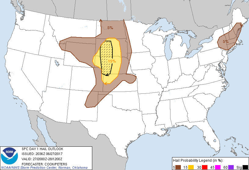
Probability of hail 1" or larger within 25 miles of a point. Hatched Area: 10% or greater probability of hail 2" or larger within 25 miles of a point.
Day 1 Hail Risk
Area (sq. mi.)
Area Pop.
Some Larger Population Centers in Risk Area
SIG SEVERE
48,752
167,700
North Platte, NE...Pierre, SD...
15 %
122,532
760,711
Rapid City, SD...Grand Island, NE...Kearney, NE...North Platte, NE...Aberdeen, SD...
5 %
356,354
16,398,853
Boston, MA...Lincoln, NE...Worcester, MA...Springfield, MA...Sioux Falls, SD...
SPC AC 272036
Day 1 Convective Outlook RESENT 3
NWS Storm Prediction Center Norman OK
0336 PM CDT Tue Jun 27 2017
Valid 272000Z - 281200Z
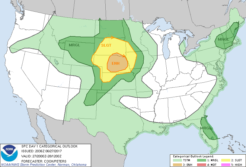
...THERE IS AN ENHANCED RISK OF SEVERE THUNDERSTORMS ACROSS PORTIONS
OF NEBRASKA AND SOUTHERN SOUTH DAKOTA...
...THERE IS A SLIGHT RISK OF SEVERE THUNDERSTORMS ACROSS THE
NORTH-CENTRAL PLAINS...
...THERE IS A MARGINAL RISK OF SEVERE THUNDERSTORMS FROM THE
NORTH-CENTRAL HIGH PLAINS TO THE UPPER MIDWEST...
...THERE IS A MARGINAL RISK OF SEVERE THUNDERSTORMS ACROSS THE
NORTHEAST STATES/NEW ENGLAND...
...THERE IS A MARGINAL RISK OF SEVERE THUNDERSTORMS ACROSS THE
FLORIDA PENINSULA...
...SUMMARY...
Severe thunderstorms capable of large hail, damaging winds and a
tornado or two are expected over much of Nebraska and South Dakota
late this afternoon and evening, with the potential for significant
wind gusts. Other strong to severe thunderstorms will be possible
across parts of the Northeast States as well as the Florida
Peninsula.
...Wyoming/Colorado High Plains eastward to southwestern Minnesota
and Iowa...
Recent satellite/radar observations and objective analyses indicate
convection developing on the western edge of an increasingly
unstable airmass advancing northward in portions of the
central/northern Plains. Observations and high-res guidance
continue to indicate that storms will gradually increase in
intensity and coverage, with one or two forward-propagating linear
segments eventually developing across western portions of South
Dakota and Nebraska. Widespread damaging wind gusts and hail are
likely with this activity, with perhaps an isolated tornado threat
also evolving especially within the enhanced risk area as low-level
shear profiles increase attendant to a strengthening low-level jet
near/after dark. Portions of the slight risk have been expanded
into western Iowa and southwestern Minnesota as recent
high-resolution guidance suggest that at least some lingering severe
threat will exist in that region after sunset as convection
develops/migrates into that area.
A small part of northeastern Kansas has been added to marginal
wind/hail probabilities as a result of a localized, persistent
cluster of storms in that area.
...Portions of the Northeast...
Scattered thunderstorms are ongoing across the marginal risk area,
with an isolated threat of hail, wind damage, and perhaps a tornado.
This threat should persist for the remainder of the afternoon before
waning some after sunset.
..Cook/Peters.. 06/27/2017
.PREV DISCUSSION... /ISSUED 1141 AM CDT Tue Jun 27 2017/
...Central/northern High Plains to middle MO Valley...
A shortwave trough and related mid/high-level speed max are readily
evident across the eastern ID/southwest MT/western WY vicinity and
adjacent Great Basin per water vapor imagery and 12Z upper-air
analysis. This eastward-progressive shortwave trough will reach the
Dakotas and middle MO valley by this evening amid a steadily
strengthening belt of mid-level westerlies.
An initial increase in widely scattered strong thunderstorm
development should occur this afternoon across interior WY (and far
southern MT), where modest moisture/buoyancy will support some
potential for severe hail and severe-caliber wind gusts. As forcing
for ascent spreads eastward, additional development should occur by
late afternoon in vicinity of the north/south-oriented lee trough,
particularly across eastern WY/NE Panhandle and Black Hills
vicinity. Large hail and damaging gusts will be possible for the
first few hours, although very steep lapse rates and a relatively
well-mixed environment should result in an upscale-growing and
eastward-accelerating complex primarily across NE this evening. As
mentioned in the prior outlook discussion, localized hurricane-force
thunderstorm gusts are possible from the most intense surges of
convection this evening.
...Northeast States/New England...
Aided by a northeast-moving shortwave trough, scattered low-topped
thunderstorms will continue to increase and spread
east/northeastward across the region this afternoon. Relatively
steep lapse rates, accentuated by cool mid-level temperatures (near
-20C at 500 mb) will support stronger low-topped storms capable of
hail, with a few low-topped supercells possible across southern New
England where deep-layer shear will be somewhat stronger. For
additional short-term information, see Mesoscale Discussion 1160.
Convection should weaken as it moves eastward over either land-based
evening diabatic cooling and/or the Atlantic marine layer.
...Florida...
Ample insolation and a moist environment will lead to moderate
buoyancy this afternoon across the FL Peninsula near and south of a
stalled front. A few thunderstorms could produce strong/locally
severe-caliber downdrafts this afternoon within a weak deep-layer
shear environment.
CLICK TO GET WUUS01 PTSDY1 PRODUCT
NOTE: THE NEXT DAY 1 OUTLOOK IS SCHEDULED BY 0100Z