Milwaukee, WI...Kansas City, MO...Omaha, NE...Lincoln, NE...Aurora, IL...
Probabilistic Damaging Wind Graphic
Probability of damaging thunderstorm winds or wind gusts of 50 knots or higher within 25 miles of a point. Hatched Area: 10% of greater probability of wind gusts 65 knots or greater within 25 miles of a point.
SPC AC 281636
Day 1 Convective Outlook
NWS Storm Prediction Center Norman OK
1136 AM CDT Wed Jun 28 2017
Valid 281630Z - 291200Z
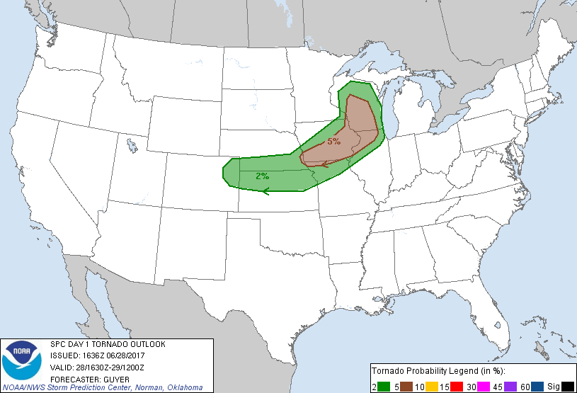
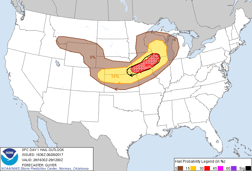
...THERE IS AN ENHANCED RISK OF SEVERE THUNDERSTORMS FROM FAR
SOUTHEAST NE INTO NORTHERN IL/SOUTHERN WI...
...THERE IS A SLIGHT RISK OF SEVERE THUNDERSTORMS FROM THE CENTRAL
HIGH PLAINS TO THE MIDDLE/UPPER MS RIVER VALLEY...
...THERE IS A MARGINAL RISK OF SEVERE THUNDERSTORMS FROM THE
NORTHERN ROCKIES TO THE GREAT LAKES...
...SUMMARY...
Severe thunderstorms with large hail, wind damage and a few
tornadoes are expected across the middle Missouri Valley
northeastward into the middle and upper Mississippi Valley. Other
more isolated severe storms may occur in the central Plains and
northern Rockies.
...Middle MO River Valley to middle/upper MS River Valley...
Related to last night's MCS, scattered showers/thunderstorms and
related prevalent cloud cover continue to progress eastward across
eastern portions of MN/IA into WI/northern IL late this morning.
This is just ahead of an eastward-moving shortwave trough over MN,
with a few other convectively related disturbances/MCVs noted
farther south, embedded within a belt of moderately strong mid-level
westerlies. A surface low analyzed at 15Z near the MN/SD/ND border
vicinity will continue to spread eastward across central MN toward
northern WI and the western Upper Peninsula of MI through this
evening, while a cold front spreads southeastward across MN/IA/WI.
Near and ahead of this cold front, low-level moistening and general
air mass recovery will steadily occur this afternoon in the wake of
the lingering early-day precipitation and cloud cover, particularly
given relatively steep mid-level lapse rates and ample low-level
moisture sampled in source-region 12Z observed soundings from Omaha
NE and Topeka KS. Increasingly prevalent mid/upper 60s F surface
dewpoints will support upwards of 2000-3000 J/kg MLCAPE particularly
from southeast NE/northern KS into IA, with somewhat more modest
(and uncertain) degree of pre-frontal destabilization farther north
into WI/eastern MN owing to early-day cloud cover and some
regenerative precipitation this morning across northern IA.
While the aforementioned cloud cover/precipitation lingering into
midday still casts some uncertainty, it seems most likely that
surface-based storms will redevelop just ahead of the front
semi-focused along outflow and zones of differential heating across
southern/eastern IA and nearby far northern MO and northern IL.
Pending adequate destabilization, other potentially severe
development may occur by late afternoon in closer proximity to the
surface low/front from far eastern MN into western/central WI.
Around 40-45 kt of effective shear will support some initial
supercells capable of large hail, with a few tornadoes possible as
well given the strength of 2-3 km AGL southwesterly winds and
related 150-250 m2/s2 0-1 km SRH (with prospective surface-based
convection). Eastward-moving clusters should evolve by evening with
a related increase in damaging wind potential particularly across
southern IA/northern MO into northern IL.
...CO/WY Front Range to northern KS/southern NE...
Within a modestly moist environment, widely scattered thunderstorms
should develop and spread eastward across the region by late
afternoon into evening, including some potential for at least
small-scale MCS development this evening. Modest buoyancy and ample
vertical shear will support the possibility of sporadic large hail
and locally damaging winds into this evening.
...Northern Rockies...
Ahead of an amplifying shortwave trough over the northern
Intermountain region, modest moisture and a strengthening belt of
west-southwesterly mid-level winds should contribute to the
possibility of isolated strong to severe storms spanning parts of
WY/southern MT and eastern ID/northern UT.
..Guyer/Dean.. 06/28/2017
CLICK TO GET WUUS01 PTSDY1 PRODUCT
NOTE: THE NEXT DAY 1 OUTLOOK IS SCHEDULED BY 2000Z