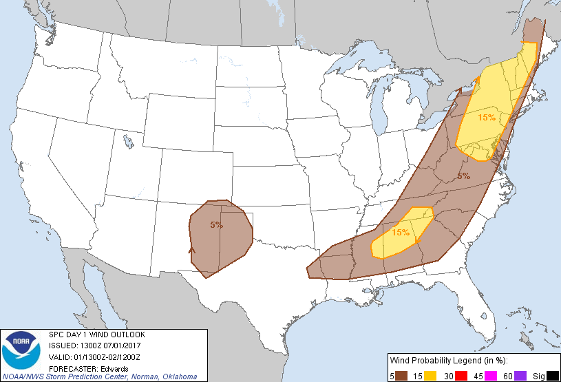
Probability of damaging thunderstorm winds or wind gusts of 50 knots or higher within 25 miles of a point. Hatched Area: 10% of greater probability of wind gusts 65 knots or greater within 25 miles of a point.
Day 1 Wind Risk
Area (sq. mi.)
Area Pop.
Some Larger Population Centers in Risk Area
15 %
170,434
36,583,864
Philadelphia, PA...Baltimore, MD...Washington, DC...Newark, NJ...Jersey City, NJ...
5 %
419,722
61,175,358
New York, NY...Charlotte, NC...Nashville, TN...Atlanta, GA...Raleigh, NC...
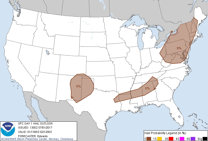
Probabilistic Large Hail Graphic
Probability of hail 1" or larger within 25 miles of a point. Hatched Area: 10% or greater probability of hail 2" or larger within 25 miles of a point.
Day 1 Hail Risk
Area (sq. mi.)
Area Pop.
Some Larger Population Centers in Risk Area
5 %
356,829
67,137,166
New York, NY...Philadelphia, PA...Baltimore, MD...Washington, DC...Pittsburgh, PA...
SPC AC 011300
Day 1 Convective Outlook
NWS Storm Prediction Center Norman OK
0800 AM CDT Sat Jul 01 2017
Valid 011300Z - 021200Z
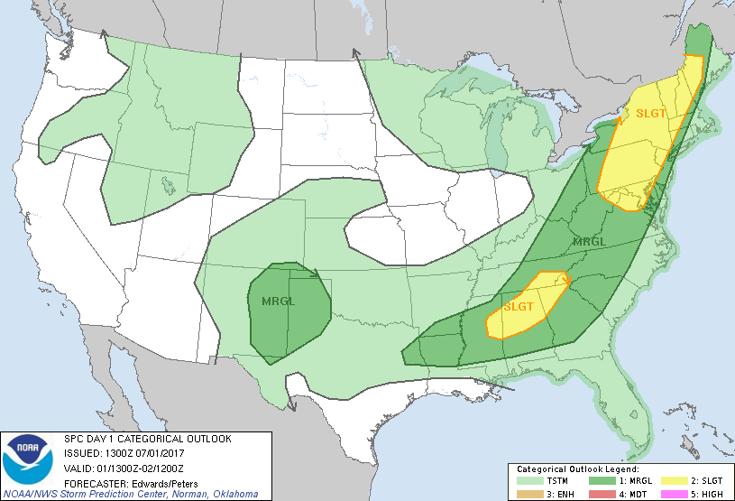
...THERE IS A SLIGHT RISK OF SEVERE THUNDERSTORMS OVER PARTS OF THE
MID ATLANTIC AND NEW ENGLAND...
...THERE IS A SLIGHT RISK OF SEVERE THUNDERSTORMS FROM PARTS OF THE
SOUTHERN APPALACHIANS TO MISSISSIPPI...
...THERE IS A MARGINAL RISK OF SEVERE THUNDERSTORMS SURROUNDING THE
SLIGHT RISKS BETWEEN EAST TEXAS AND NEW ENGLAND...
...THERE IS A MARGINAL RISK OF SEVERE THUNDERSTORMS OVER PARTS OF
NEW MEXICO TO THE SOUTHERN HIGH PLAINS...
...SUMMARY...
Isolated to scattered severe thunderstorms, primarily capable of
wind damage, are forecast across the Northeast southward into the
Mid-Atlantic states. Strong to locally severe thunderstorms are
also possible across the southern Appalachians and into Mississippi.
Other strong-severe storms are possible this afternoon and tonight
over parts of New Mexico across the southern High Plains.
...Synopsis...
In mid/upper levels, a cyclonic flow field will shift eastward
across parts of the Upper Midwest, Great Lakes and Northeast. This
will occur as a series of vorticity maxima and shortwaves rotate
through the southern semicircle of a loosely organized, broad
cyclone centered over northern ON and eventually the James Bay
region. A weak, leading, positively tilted perturbation -- now
located from Lake Erie to eastern KY and supporting precip over
portions of PA/NY -- will eject northeastward across the Mid
Atlantic and New England today. Upstream, a somewhat stronger
shortwave trough was evident in moisture-channel imagery from Lake
Michigan to eastern KS. This feature should weaken gradually as it
ejects northeastward to southern ON, Lake Ontario and OH by 00Z,
then over southern/central QC by the end of the period. A stronger
shortwave trough -- occasionally manifest as a closed 500-mb low --
will move southeastward from the Lake Winnipeg region to the Lake
Superior region by 12Z.
At the surface, an occluded low was analyzed at 11Z over eastern
Lake Superior with a triple point over northwestern Lake Huron. The
warm front extended from there east-southeastward across the
Adirondacks and VT/NH, and should move northward today, with some
diffusion amidst clouds/precip shifting eastward out of the Lake
Ontario region and adjoining parts of NY. The cold front was drawn
from Lower MI to the northern Ozarks in MO, through a weak low near
TUL, southwestward across the Permian Basin of west TX. Outflow
boundaries preceded the front from southwest TX to western portions
of TN and KY. A new low should develop on the triple point by
mid/late afternoon over southern QC, with the 00Z cold-frontal
position from central parts of NY/PA southwestward across AR. The
front will become quasistationary and ill-defined from there to
southwest TX.
...Northeast/Mid Atlantic...
Scattered thunderstorms are forecast to develop this afternoon in
multiple/broken corridors along and ahead of the front, moving
northeastward while posing a risk for damaging gusts. Isolated
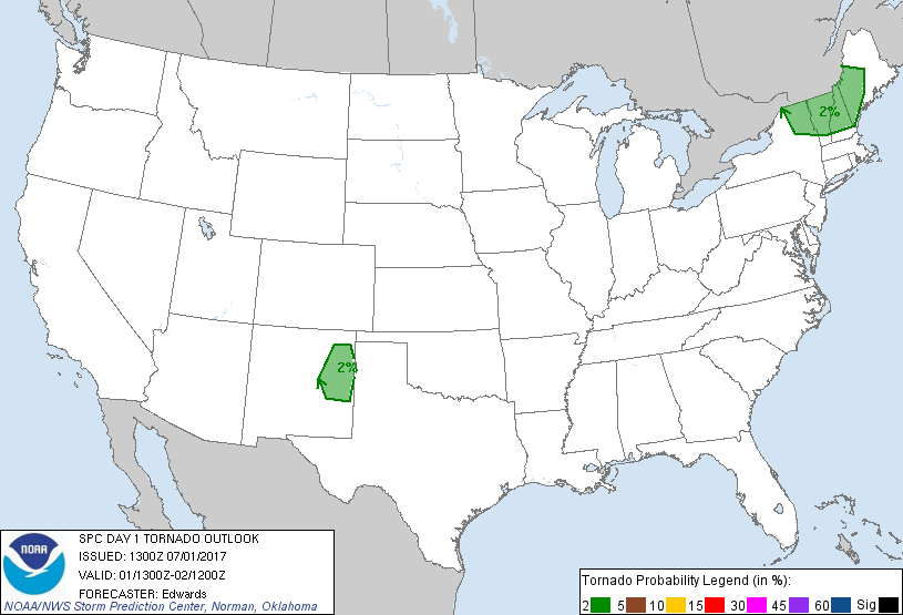
large hail is possible. A tornado cannot be ruled out portions of
the Adirondack/northern New England region where low-level shear
will be greatest nearer to the warm front. Overall convective
coverage/intensity should wane after 00Z.
Large-scale ascent will be greatest but sustained diabatic surface
heating weakest over the northern areas -- NY/New England -- given
the ongoing areas of precip across western/central NY and western
PA. Still, the heating that does occur, in tandem with weak MLCINH
and lift along the surface front, prefrontal confluence zones/
troughs and differential-heating/outflow boundaries, will be more
than enough to support convection by afternoon. Forecast soundings
suggest that 30-40 kt of midlevel (i.e., 700-500-mb) winds and the
surface southerly component will support 30-40-kt effective-shear
magnitudes. Areas of locally backed surface winds and/or
vorticity-enhanced boundaries further will support some supercell
potential in addition to multicells and small bows.
The severe potential is expected to transition from a multimodal
threat over the north -- where shear is stronger and buoyancy weaker
but still adequate -- to multicellular wind and marginal hail in the
higher-CAPE/weaker-shear MD/VA region. Forecast soundings suggest
surface temps heating into the 90s F, with dew points upper 60s to
mid 70s and 1.5-2-inch PW -- offset modest mid/upper-level lapse
rates to yield 1500-2000 J/kg MLCAPE, locally higher. Shallow but
well-mixed boundary layers will support the potential for damaging
gusts, a few perhaps exceeding severe limits.
...Southern States...
Scattered thunderstorms in clusters are expected to form this
afternoon along and ahead of the aggregate outflow boundary from
prior convection, offering the potential for damaging downburst
winds, isolated gusts near severe limits, and isolated large hail.
This should be mainly a diurnal threat, but with isolated severe
possible into the mid/late evening. Forecast soundings suggest
well-mixed subcloud layers, but still with rich boundary-layer
moisture, contributing to MLCAPE ranges from 2000-3000 J/kg in MS to
500-1000 J/kg across eastern TN. The area will reside beneath, or
just off, the southern fringes of the cyclonic-flow field aloft,
somewhat stronger over TN than farther southwest, with 20-30 kt
500-mb flow and nearly unidirectional vertical wind profiles
overall. Organized multicells, outflow-dominant clusters and
perhaps a few bows are possible, and transient supercell evolutions
may occur relatively early in the convective cycle and/or near any
vorticity-rich boundaries.
...Southern Rockies/High Plains...
Isolated to widely scattered thunderstorms are expected to form in
higher terrain of central/northern NM and move generally
southeastward, with isolated large hail and damaging gusts possible.
Surface diabatic heating will remove CINH effectively, while
residual surface moisture and a weak upslope-flow regime contribute
to buoyancy and lift.
Surface dew points generally in the 50s and low 60s F, overlain by
steep midlevel lapse rates, will support MLCAPE 1500-2500 J/kg,
amidst well-mixed subcloud layers with high DCAPE. Even though
low/middle-level flow will remain modest, strong directional shear
and favorable storm-relative boundary-layer winds will enable
convection to persist for several hours, at least into this evening,
across the southern High Plains. Some of this activity may
aggregate into forward-propagating/cold-pool-driven bands or
clusters this evening over the High Plains, leading to a somewhat
more-concentrated damaging-wind threat than the broadbrushed 5% area
now depicts. Given the storm-scale to mesoscale dependency of such
processes, in the absence of any substantial large-scale/upper-level
support, predictability is too low at this time to narrow down a
specific swath of greater wind probabilities. However, an upgrade
may be needed for part of this area as mesoscale trends warrant
today.
..Edwards/Peters.. 07/01/2017
CLICK TO GET WUUS01 PTSDY1 PRODUCT
NOTE: THE NEXT DAY 1 OUTLOOK IS SCHEDULED BY 1630Z