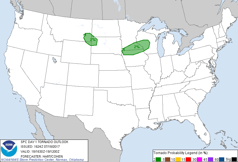
Probability of a tornado within 25 miles of a point. Hatched Area: 10% or greater probability of EF2 - EF5 tornadoes within 25 miles of a point.
Day 1 Tornado Risk
Area (sq. mi.)
Area Pop.
Some Larger Population Centers in Risk Area
2 %
58,098
2,302,878
Rochester, MN...Eau Claire, WI...Burnsville, MN...Lakeville, MN...Apple Valley, MN...
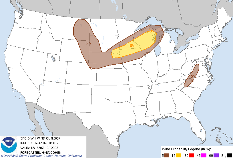
Probabilistic Damaging Wind Graphic
Probability of damaging thunderstorm winds or wind gusts of 50 knots or higher within 25 miles of a point. Hatched Area: 10% of greater probability of wind gusts 65 knots or greater within 25 miles of a point.
Day 1 Wind Risk
Area (sq. mi.)
Area Pop.
Some Larger Population Centers in Risk Area
15 %
89,065
5,501,132
St. Paul, MN...Sioux Falls, SD...Green Bay, WI...Rochester, MN...Sioux City, IA...
SPC AC 181624
Day 1 Convective Outlook
NWS Storm Prediction Center Norman OK
1124 AM CDT Tue Jul 18 2017
Valid 181630Z - 191200Z
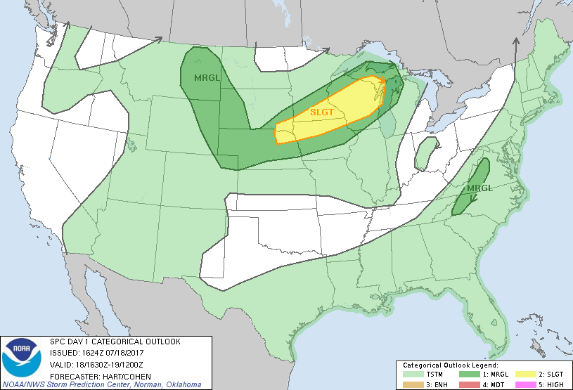
...THERE IS A SLIGHT RISK OF SEVERE THUNDERSTORMS FROM PARTS OF
SD/NE INTO WI AND UPPER MI...
...THERE IS A MARGINAL RISK OF SEVERE THUNDERSTORMS OVER MUCH OF THE
NORTHERN PLAINS AND UPPER MIDWEST...
...THERE IS A MARGINAL RISK OF SEVERE THUNDERSTORMS OVER PARTS OF
VA/NC...
...SUMMARY...
Strong to severe thunderstorms are expected to develop this
afternoon across the Upper Midwest with a few instances of locally
damaging wind and hail the main threats. A few strong to severe
storms are also possible over a portion of the central and northern
Plains this afternoon and overnight. Isolated marginally severe
hail and winds will be possible for a few hours this afternoon near
the Blue Ridge.
...Upper Midwest and Western Great Lakes Region...
The primary band of mid-level westerlies extends from the northern
Rockies across the northern Plains and into the Great Lakes region.
Scattered clusters of thunderstorms have affected this zone
overnight, leaving considerable clouds and limited heating. Two
areas where stronger heating is likely to take place, along with
associated destabilization and potentially increased severe risk
will be over parts of WI into Upper MI ahead of the remnant
convection south of Duluth, and along the boundary over northern SD.
Both of these areas should see at least moderate CAPE values and
sufficient shear aloft for organized storms later today. Have
expanded the risk areas farther east in WI and Lake Michigan to
account for that concern, while the other area was well-contained in
the existing SLGT risk.
...Northern High Plains...
Isolated thunderstorms are likely to develop this evening over
eastern MT, drifting into southwest ND and western SD overnight.
Forecast soundings suggest parameters favorable for rotating storms
capable of hail and damaging winds. The primary mitigating factors
for a more organized severe event are the weak forcing mechanisms
and the anticipated sparse coverage of storms.
...VA/NC...
Scattered afternoon thunderstorms are expected to develop this
afternoon beneath a weak upper trough centered over parts of NC/VA.
Thermodynamic profiles are marginally favorable for brief hail and
gusty winds in the stronger cells. However, near-calm winds through
much of the troposphere will lead to disorganized and pulse
convective modes.
..Hart/Cohen.. 07/18/2017
CLICK TO GET WUUS01 PTSDY1 PRODUCT
NOTE: THE NEXT DAY 1 OUTLOOK IS SCHEDULED BY 2000Z