Probability of damaging thunderstorm winds or wind gusts of 50 knots or higher within 25 miles of a point. Hatched Area: 10% of greater probability of wind gusts 65 knots or greater within 25 miles of a point.
SPC AC 201226
Day 1 Convective Outlook
NWS Storm Prediction Center Norman OK
0726 AM CDT Thu Jul 20 2017
Valid 201300Z - 211200Z
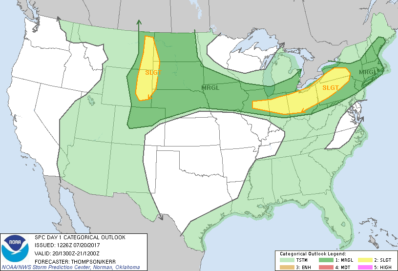
...THERE IS A SLIGHT RISK OF SEVERE THUNDERSTORMS THIS AFTERNOON
INTO EARLY TONIGHT FROM PARTS OF ILLINOIS TO WESTERN NEW YORK...
...THERE IS A SLIGHT RISK OF SEVERE THUNDERSTORMS THIS
AFTERNOON/EVENING FOR THE NORTHERN HIGH PLAINS...
...THERE IS A MARGINAL RISK OF SEVERE THUNDERSTORMS IN A BROAD AREA
FROM PARTS OF NEW ENGLAND TO THE MIDWEST AND NORTHERN PLAINS...
...SUMMARY...
A few severe storms with wind or hail are possible across the
northern High Plains, and from parts of the Midwest into the
Northeast this afternoon.
...Lower Great Lakes into New England this afternoon...
A midlevel shortwave trough over the upper Great Lakes this morning
will reach the Saint Lawrence Valley by this evening, along with an
associated/weak surface cold front. Boundary-layer dewpoints
increasing into the upper 60s and surface heating within cloud
breaks downstream from the northern IL MCS/cloud debris will drive
sufficient buoyancy for strong updrafts this afternoon. As
evidenced by the convection now forming over Lake Huron,
thunderstorms should form over or move into western NY by early
afternoon. An increase in deep-layer vertical shear with the
approach of the midlevel trough and MLCAPE of 1000-2000 J/kg will
support a threat for damaging gusts with organized cells/clusters
this afternoon.
...OH Valley/Upper Midwest through tonight...
An ongoing MCS over northern IL has been maintained by a moisture
feed from IA in a warm advection regime above the cold pool of an
earlier MCS that dissipated over northern IN last night. The IL MCS
will continue moving to the southeast this morning, but should
weaken slowly as warm advection diminishes and the associated
midlevel trough moves eastward over MI. Some additional storm
development may occur along the outflow boundaries and in
conjunction with a residual MCV from the overnight storms, though
lingering clouds and minimal forcing for ascent cast doubt on the
extent of afternoon convection toward IN/OH. Instead, renewed
thunderstorm development could be delayed until this evening along
the outflow-reinforced cold front from IL into IA, with storms
expected to move southeastward into tonight. Damaging winds and
isolated large hail will be the main threats.
...Northern High Plains area this afternoon into tonight...
A midlevel trough over the Pacific Northwest will crest the
flattened ridge over the Rockies and reach the northern High Plains
tonight. Associated lee cyclogenesis is expected across eastern MT,
with a lee trough extending southward across the High Plains.
Residual boundary-layer dewpoints ranging from the 60s in western SD
to the 50s near the ND/MT border will combine with strong surface
heating and steep midlevel lapse rates to boost MLCAPE into the
1500-2500 J/kg range as convective inhibition weakens along the lee
trough. The initial widely scattered storms could be supercells
capable of producing large hail and damaging winds, given the
moderate buoyancy, somewhat high cloud bases and effective bulk
shear of 35-45 kt (especially from northwest SD into eastern MT).
Convection could grow into a cluster or two and persist into tonight
with a marginal wind/hail risk.
Otherwise, a few strong storms may occur this afternoon/evening with
the lingering MCV from overnight convection in NE, and in a
developing warm advection regime late tonight toward eastern ND.
..Thompson/Kerr.. 07/20/2017
CLICK TO GET WUUS01 PTSDY1 PRODUCT
NOTE: THE NEXT DAY 1 OUTLOOK IS SCHEDULED BY 1630Z