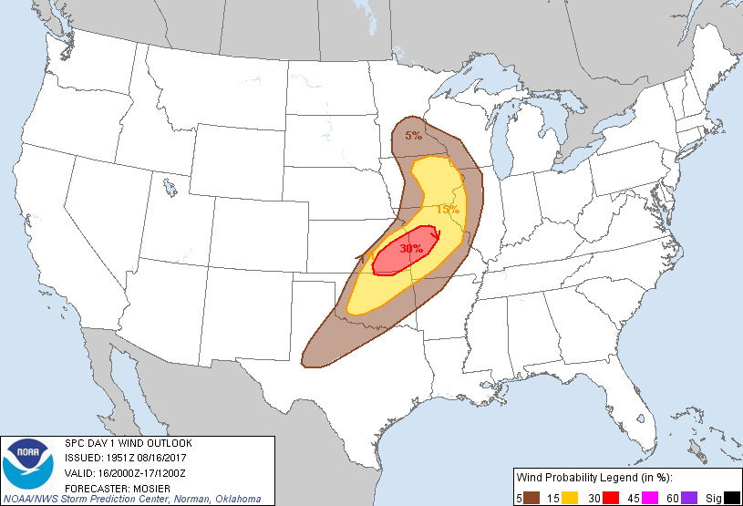
Kansas City, MO...Wichita, KS...Des Moines, IA...Overland Park, KS...Kansas City, KS...
Probabilistic Damaging Wind Graphic
Probability of damaging thunderstorm winds or wind gusts of 50 knots or higher within 25 miles of a point. Hatched Area: 10% of greater probability of wind gusts 65 knots or greater within 25 miles of a point.
Day 1 Wind Risk
Area (sq. mi.)
Area Pop.
Some Larger Population Centers in Risk Area
30 %
27,993
2,345,257
Kansas City, MO...Overland Park, KS...Kansas City, KS...Olathe, KS...Independence, MO...
15 %
106,159
8,314,183
Oklahoma City, OK...Tulsa, OK...Wichita, KS...Springfield, MO...Cedar Rapids, IA...
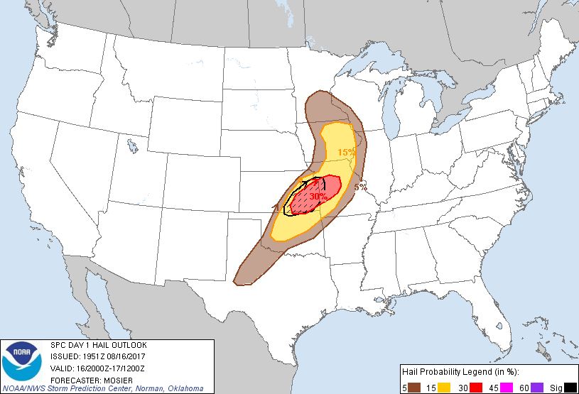
Probability of hail 1" or larger within 25 miles of a point. Hatched Area: 10% or greater probability of hail 2" or larger within 25 miles of a point.
Day 1 Hail Risk
Area (sq. mi.)
Area Pop.
Some Larger Population Centers in Risk Area
SIG SEVERE
25,213
3,124,842
Kansas City, MO...Wichita, KS...Overland Park, KS...Kansas City, KS...Topeka, KS...
30 %
28,053
2,609,556
Kansas City, MO...Overland Park, KS...Kansas City, KS...Olathe, KS...Independence, MO...
15 %
91,485
6,951,508
Oklahoma City, OK...Tulsa, OK...Wichita, KS...Des Moines, IA...Springfield, MO...
5 %
121,769
8,462,083
Minneapolis, MN...St. Paul, MN...Wichita Falls, TX...Midland, TX...Davenport, IA...
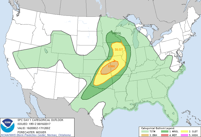
   SPC AC 161951

   Day 1 Convective Outlook
   NWS Storm Prediction Center Norman OK
   0251 PM CDT Wed Aug 16 2017

   Valid 162000Z - 171200Z

   ...THERE IS AN ENHANCED RISK OF SEVERE THUNDERSTORMS FROM SOUTHEAST
   KANSAS INTO WEST-CENTRAL MISSOURI...

   ...THERE IS A SLIGHT RISK OF SEVERE THUNDERSTORMS FROM OKLAHOMA
   ACROSS THE LOWER MISSOURI VALLEY INTO IOWA...

   ...THERE IS A MARGINAL RISK OF SEVERE THUNDERSTORMS FROM THE
   SOUTHERN PLAINS INTO THE UPPER MISSISSIPPI VALLEY...

   ...SUMMARY...
   Scattered to numerous severe storms are likely from Iowa to
   Oklahoma, mainly later this afternoon and evening. Large hail,
   damaging winds, and a couple of tornadic storms are expected.

   ...20Z Update...
   Outlook was trimmed from the west based on current trends and the
   current position of the cold front. Severe thunderstorms are still
   expected across southeast KS and central/southeast MO within the
   next hour or two. More information about the storms in this area can
   be found in MCD 1507 and Severe Thunderstorm Watch 453. More
   localized coverage is anticipated farther south along the front into
   central/southwest OK but, given the favorable thermodynamic and
   kinematic environment across the area, large hail and damaging wind
   gusts are still likely with any storms that do develop.

   A more linear structure is present with the storms across central
   MO, where occasional damaging wind gusts and isolated hail remain
   possible as they continue eastward/northeastward. More information
   about the storms in this region is available in MCD 1508.

   Several bands of convection exist across IA. The northernmost band
   is associated with the warm front across the region while the more
   southern band is associated with the mid-level dry slot of the
   maturing upper system. A few stronger updrafts are possible within
   the narrow band of instability over the area with damaging wind
   gusts as the primary severe threat. Enhanced surface vorticity
   across the region could also contribute to a transient/short-lived
   tornado or two.

   ..Mosier.. 08/16/2017

   .PREV DISCUSSION... /ISSUED 1205 PM CDT Wed Aug 16 2017/

   ...Upper Mississippi Valley into the Southern Plains...
   Water vapor imagery shows a strong trough/vorticity maxima lifting
   into southwest Nebraska this morning.  This system is forecast to
   continue toward the upper Mississippi Valley tonight as a mid-upper
   level jet streak moves northeast on the southern periphery of the
   system.  An associated surface low over extreme eastern Nebraska is
   expected to move into extreme southwest Minnesota by evening and
   continue across southern Minnesota tonight.  A cold front trailing
   southward from the low will progress eastward and southeastward
   through the period.

   A key mesoscale feature impacting thunderstorm evolution this
   afternoon is an arcing band of convection from western Iowa
   southward into extreme northwest Missouri and southeast Kansas.  The
   intersection of the western extension of this boundary over Kansas
   with the advancing cold front is expected to serve as a focus area
   for new convective initiation this afternoon, with activity
   expanding in coverage as storms move northeastward into the lower
   Missouri Valley this evening.  In addition, there is potential for
   ongoing storms in parts of Iowa and Missouri to intensify this
   afternoon as they move into a warming and destabilizing environment.

   The air mass from Oklahoma into central Missouri is undergoing
   strong diabatic heating, and there is potential for some
   thermodynamic recovery into parts of eastern Kansas in the wake of
   the downstream convection as clouds diminish to the north of the
   outflow boundary and ahead of the cold front.  Moderate to strong
   instability is expected this afternoon with MLCAPE reaching
   2000-3000 J/kg.  Winds aloft will be veering with height and
   increasing in magnitude during the afternoon which will provide
   sufficient vertical shear /35-40 kt in the lowest 6 km/ to support
   organized convective structures including a few initial supercells.
   It appears that convection will evolve into a series of linear
   segments with time that may include a few bowing elements.  All
   severe hazards including large hail, damaging winds, and several
   tornadoes will be possible, especially during the earlier stages of
   severe storm maturation when the likelihood of discrete cells will
   be the greatest.  The threat is expected to evolve into primarily a
   damaging wind threat during the evening with some severe potential
   continuing into the early overnight hours.

   Farther north, the slight risk has been extended northward into
   parts of central/eastern Iowa where visible imagery shows some
   breaks in clouds which will promote heating and air mass
   destabilization.  Strong forcing for ascent along/in advance of the
   ongoing convective band coupled with favorable shear profiles
   suggest potential for a few severe storms to develop this afternoon
   and early evening.

   CLICK TO GET WUUS01 PTSDY1 PRODUCT

   NOTE: THE NEXT DAY 1 OUTLOOK IS SCHEDULED BY 0100Z