Probability of a tornado within 25 miles of a point. Hatched Area: 10% or greater probability of EF2 - EF5 tornadoes within 25 miles of a point.
Day 1 Tornado Risk
Area (sq. mi.)
Area Pop.
Some Larger Population Centers in Risk Area
2 %
61,026
3,614,302
Omaha, NE...Des Moines, IA...Cedar Rapids, IA...Sioux City, IA...Waterloo, IA...
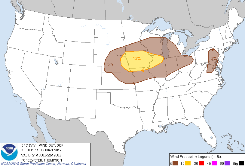
Probabilistic Damaging Wind Graphic
Probability of damaging thunderstorm winds or wind gusts of 50 knots or higher within 25 miles of a point. Hatched Area: 10% of greater probability of wind gusts 65 knots or greater within 25 miles of a point.
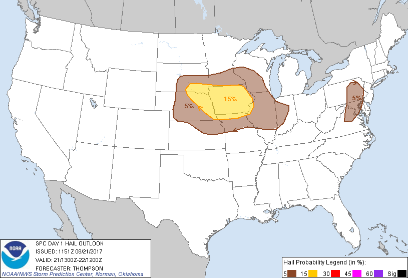
Probability of hail 1" or larger within 25 miles of a point. Hatched Area: 10% or greater probability of hail 2" or larger within 25 miles of a point.
Day 1 Hail Risk
Area (sq. mi.)
Area Pop.
Some Larger Population Centers in Risk Area
15 %
94,288
4,864,636
Omaha, NE...Lincoln, NE...Des Moines, IA...Sioux Falls, SD...Cedar Rapids, IA...
5 %
222,338
36,152,089
Indianapolis, IN...Baltimore, MD...Washington, DC...Kansas City, MO...Minneapolis, MN...
SPC AC 211151
Day 1 Convective Outlook
NWS Storm Prediction Center Norman OK
0651 AM CDT Mon Aug 21 2017
Valid 211300Z - 221200Z
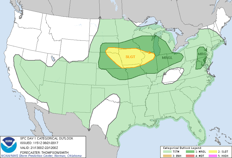
...THERE IS A SLIGHT RISK OF SEVERE THUNDERSTORMS THROUGH EARLY
TONIGHT FROM SOUTHEASTERN SD TO IA AND NORTHERN IL...
...THERE IS A MARGINAL RISK OF SEVERE THUNDERSTORMS SURROUNDING THE
SLIGHT RISK AREA...FROM THE CENTRAL PLAINS TO PARTS OF THE OH VALLEY
AND GREAT LAKES...
...THERE IS A MARGINAL RISK OF SEVERE THUNDERSTORMS THIS
AFTERNOON/EVENING FOR NORTHERN VA TO EASTERN PA...
...SUMMARY...
Isolated large hail and damaging winds will be possible with a
couple of rounds of thunderstorms through tonight from parts of the
central Plains to the upper Mississippi Valley. A low-end
severe-storm threat will also extend eastward into northern Ohio,
and from northern Virginia to eastern Pennsylvania.
...Central Plains to the upper MS Valley through tonight...
A midlevel trough over the Canadian prairie provinces and northern
High Plains will progress east-southeastward to the upper MS Valley
by early Tuesday, as an associated surface cold front translates
southeastward across the upper MS Valley and into the central
Plains. The distribution of steeper midlevel lapse rates and richer
low-level moisture will be affected today by an ongoing MCS over IA,
and a subtropical moisture plume spreading northeastward from the
southern High Plains. Though the IA MCS should weaken slowly
through the morning, its associated outflow has already spread into
southeastern NE and far northern MO. Meanwhile, a midlevel
vorticity center over the southern High Plains will continue to move
northeastward, while associated mid/high-level moisture north-east
of the vorticity center will overspread western/central KS and
southern NE today.
The increasing clouds will tend to slow surface heating by afternoon
along and southwest of the residual outflow boundary, which brings
into question the prospects for surface-based storm development.
Likewise, the widespread convective overturning in IA and
reinforcement of the outflow will likely hinder destabilization and
reduce the severe-weather threat farther north-northeast in MN/WI.
The more probable scenario appears to be for convection to increase
along the synoptic cold front later this afternoon/evening across NE
and northwestern IA, as forcing for ascent (as evidenced by the
ongoing elevated storms across northern SD) overspreads the
boundary. A separate band of convection may form on the east edge
of the subtropical moisture plume across KS where surface heating
and buoyancy will be greater. Multicell clusters and line segments
will be the more probable storm modes, given that the stronger
deep-layer vertical shear will reside generally north of the
stronger buoyancy, and the cold front will be the primary initiation
source. Large hail and damaging gusts will be the main severe
threats this afternoon into early tonight, when the severe-weather
threat will begin to diminish.
...Northern VA to eastern PA this afternoon/evening...
A subtle midlevel trough over northern OH this morning will reach
eastern PA later this afternoon. At the surface, a weak lee trough
from northern VA into eastern PA will help to focus semi-discrete
thunderstorm development this afternoon as the midlevel trough
approaches. Midlevel lapse rates will not be steep, but boundary
layer dewpoints increasing into the upper 60s to lower 70s and
daytime heating will drive MLCAPE values into the 1500-2000 J/kg
range. Effective bulk shear will also increase to 30-35 kt, which
is representative of a low-end supercell environment where storms
could produce marginally severe hail and isolated strong/damaging
outflow gusts.
..Thompson/Smith.. 08/21/2017
CLICK TO GET WUUS01 PTSDY1 PRODUCT
NOTE: THE NEXT DAY 1 OUTLOOK IS SCHEDULED BY 1630Z