Newark, NJ...Jersey City, NJ...Yonkers, NY...Worcester, MA...Springfield, MA...
Probabilistic Damaging Wind Graphic
Probability of damaging thunderstorm winds or wind gusts of 50 knots or higher within 25 miles of a point. Hatched Area: 10% of greater probability of wind gusts 65 knots or greater within 25 miles of a point.
New York, NY...Baltimore, MD...Boston, MA...Oklahoma City, OK...Newark, NJ...
Probabilistic Large Hail Graphic
Probability of hail 1" or larger within 25 miles of a point. Hatched Area: 10% or greater probability of hail 2" or larger within 25 miles of a point.
Day 1 Hail Risk
Area (sq. mi.)
Area Pop.
Some Larger Population Centers in Risk Area
No Risk Areas Forecast
SPC AC 230100
Day 1 Convective Outlook
NWS Storm Prediction Center Norman OK
0800 PM CDT Tue Aug 22 2017
Valid 230100Z - 231200Z
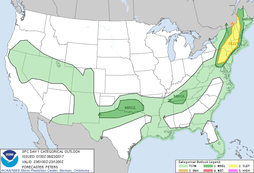
...THERE IS A SLIGHT RISK OF SEVERE THUNDERSTORMS ACROSS EASTERN
PA...NORTHERN NJ...SOUTHEAST NY INTO NEW ENGLAND...
...THERE IS A MARGINAL RISK OF SEVERE THUNDERSTORMS SURROUNDING THE
NORTHEAST U.S. SLIGHT RISK AREA...
...THERE IS A MARGINAL RISK OF SEVERE THUNDERSTORMS FROM PARTS OF
MIDDLE AND EASTERN TN INTO NORTHERN AL...
...THERE IS A MARGINAL RISK OF SEVERE THUNDERSTORMS FOR PART OF THE
SOUTHERN PLAINS...
...SUMMARY...
Scattered strong to severe storms remain a threat across eastern
Pennsylvania into parts of New England this evening and perhaps to
the early overnight.
...Northeast States...
Although instability will be weakening, given loss of daytime
heating, storms will continue to spread across eastern PA into
northern NJ and southeast NY to parts of New England this evening to
the early overnight, as strong forcing for ascent should compensate
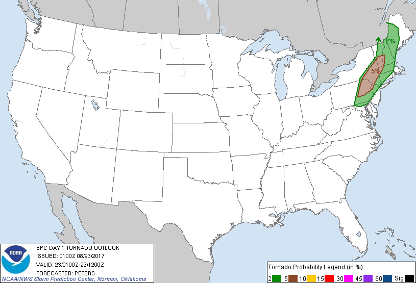
for the weaker instability in the short term. Strongly sheared
environment, as deep-layer winds strengthen into New England, will
continue to favor storm organization with low-level rotation
remaining possible for a tornado or two.
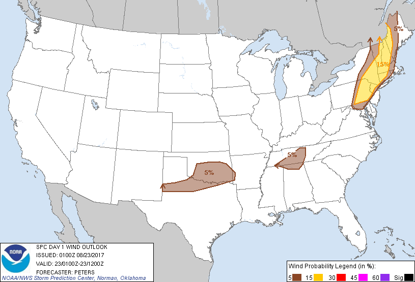
...Portions of middle and eastern TN and northern AL...
A band of storms will continue to advance to the south-southeast
through middle into parts of eastern TN, and perhaps northern AL yet
this evening. Although instability will undergo further weakening,
given the loss of daytime heating, forcing for ascent attendant to
the southern extent of the Great Lakes/OH Valley may compensate
allowing for an additional strong to severe storm. Weak effective
bulk shear will preclude storm organization, though water-loaded
downdrafts per precipitable water ranging from 1.5-2.0 inches and
cold pool development could locally enhance the threat for
stronger/damaging wind gusts. This threat should wane by late
evening, as surface-based inhibition will become too strong to
overcome for stronger momentum air to reach the ground.
...Southern Plains...
Storm mergers across northwest/west-central TX and across OK will
continue to pose a threat for locally strong/damaging wind gusts,
given residual moderate instability, high precipitable water of
1.5-2.0 inches, and some cold pool development enhancing this
isolated severe threat this evening.
..Peters.. 08/23/2017
CLICK TO GET WUUS01 PTSDY1 PRODUCT
NOTE: THE NEXT DAY 1 OUTLOOK IS SCHEDULED BY 0600Z