New Orleans, LA...Baton Rouge, LA...Montgomery, AL...Metairie, LA...Tuscaloosa, AL...
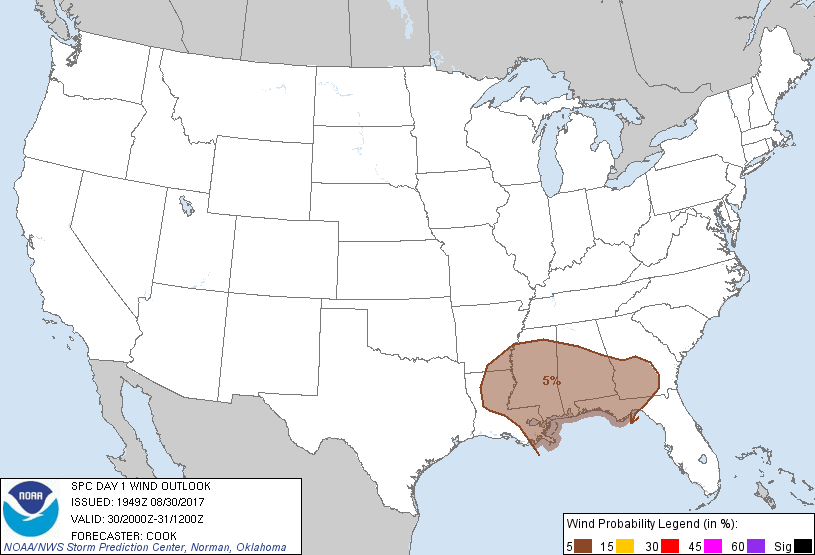
Probabilistic Damaging Wind Graphic
Probability of damaging thunderstorm winds or wind gusts of 50 knots or higher within 25 miles of a point. Hatched Area: 10% of greater probability of wind gusts 65 knots or greater within 25 miles of a point.
Day 1 Wind Risk
Area (sq. mi.)
Area Pop.
Some Larger Population Centers in Risk Area
5 %
149,695
11,447,380
New Orleans, LA...Birmingham, AL...Baton Rouge, LA...Montgomery, AL...Mobile, AL...
Probabilistic Large Hail Graphic
Probability of hail 1" or larger within 25 miles of a point. Hatched Area: 10% or greater probability of hail 2" or larger within 25 miles of a point.
Day 1 Hail Risk
Area (sq. mi.)
Area Pop.
Some Larger Population Centers in Risk Area
No Risk Areas Forecast
SPC AC 301949
Day 1 Convective Outlook
NWS Storm Prediction Center Norman OK
0249 PM CDT Wed Aug 30 2017
Valid 302000Z - 311200Z
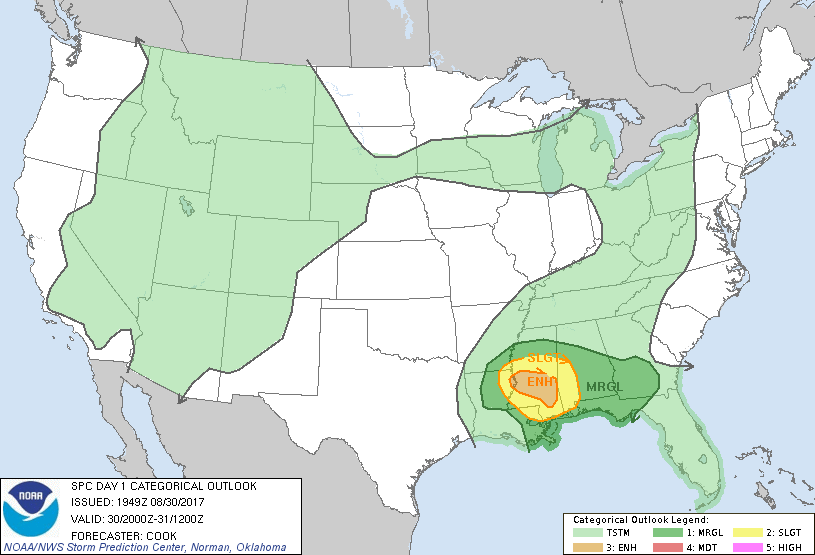
...THERE IS AN ENHANCED RISK OF SEVERE THUNDERSTORMS ACROSS PORTIONS
OF CENTRAL AND SOUTHERN MISSISSIPPI...
...THERE IS A SLIGHT RISK OF SEVERE THUNDERSTORMS SURROUNDING THE
ENHANCED RISK FROM THE ARK-LA-MISS INTO WESTERN ALABAMA...
...THERE IS A MARGINAL RISK OF SEVERE THUNDERSTORMS ACROSS THE LOWER
MISSISSIPPI VALLEY AND DEEP SOUTH...
...SUMMARY...
Some tornadoes are likely from the Ark-La-Miss to western Alabama
this afternoon and evening.
...20Z Outlook Update...
The general forecast scenario has exhibited mostly minimal changes
through mid-afternoon. Low (5%) probabilities for damaging wind
gusts have been expanded eastward into portions of central and
southern Georgia in advance of a broken linear segment that has
begun to forward propagate near the Albany, GA vicinity. Satellite
imagery indicates continued surface heating ahead of this band of
storms, and objective analyses indicate roughly 1000-2500 J/kg
MUCAPE, which should continue to support an isolated severe threat
for the next several hours.
Additionally, the Slight risk was expanded eastward into a greater
portion of western and southwestern Alabama ahead of a band of
storms that have been exhibiting supercellular characteristics
near/east of the Mobile area. Surface heating and backed low-level
flow ahead of this band will support an isolated wind/tornado threat
over the next few hours, and observations/high-resolution guidance
suggest a gradual northward shift of this threat into the evening.
A band of storms has evolved over eastward Wisconsin today, but has
been sub-severe throughout its existence. A general lack of
vertical wind shear should result in any severe threat being too
isolated to warrant any severe probabilities for this outlook.
..Cook.. 08/30/2017
.PREV DISCUSSION... /ISSUED 1127 AM CDT Wed Aug 30 2017/
...Ark-La-Miss to AL...
Broken clouds to the east of the mid-level dry slot are allowing for
destabilization across most of southern LA/MS with surface
temperatures warming towards the middle 80s. Modified 12Z
Jackson/Slidell soundings along with 12Z NAM forecast soundings
suggest this will result in pockets of MLCAPE reaching 1000-2000
J/kg. Within a belt of 30-45 kt 850-mb southerlies and where surface
east-southeasterlies persist, low-level hodographs will support
updraft rotation. The most favorable combination of shear/buoyancy
should be present from northeast LA across southern MS where at
least a few tornadoes are likely amid multiple broken convective
bands moving northeast this afternoon. Morning CAMs suggest the
tornado threat will nocturnally wane, but a marginal tornado risk
may persist overnight.
...WI...
Small hail and gusty winds may accompany a broken line of storms
moving south along a cold front this afternoon. Although mid-level
lapse rates are steep, weak unidirectional wind profiles should
preclude stronger updraft intensity and discourage an organized
severe risk.
CLICK TO GET WUUS01 PTSDY1 PRODUCT
NOTE: THE NEXT DAY 1 OUTLOOK IS SCHEDULED BY 0100Z