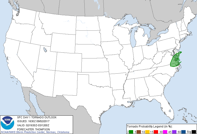
Virginia Beach, VA...Norfolk, VA...Chesapeake, VA...Newport News, VA...Hampton, VA...
Probabilistic Tornado Graphic
Probability of a tornado within 25 miles of a point. Hatched Area: 10% or greater probability of EF2 - EF5 tornadoes within 25 miles of a point.
Day 1 Tornado Risk
Area (sq. mi.)
Area Pop.
Some Larger Population Centers in Risk Area
2 %
17,375
2,496,788
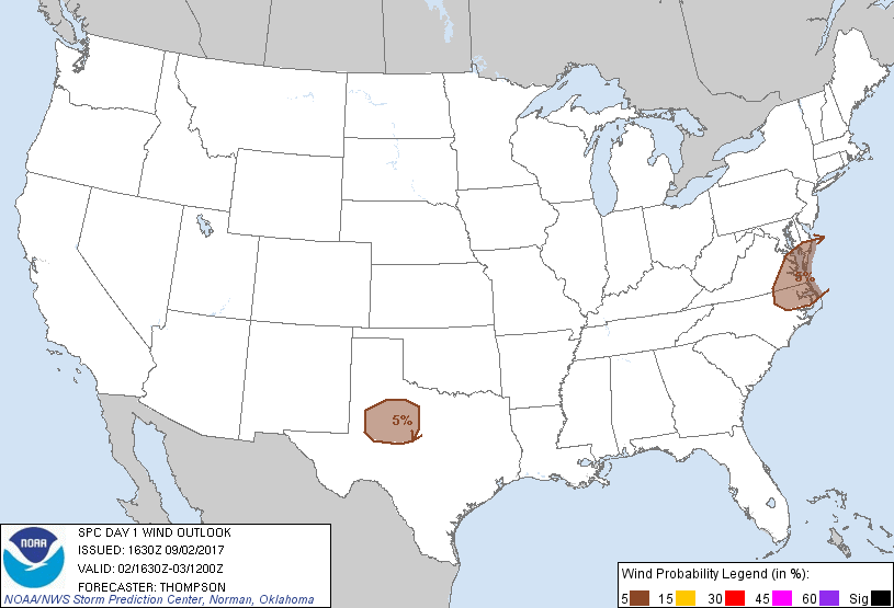
Virginia Beach, VA...Norfolk, VA...Chesapeake, VA...Newport News, VA...Hampton, VA...
Probabilistic Damaging Wind Graphic
Probability of damaging thunderstorm winds or wind gusts of 50 knots or higher within 25 miles of a point. Hatched Area: 10% of greater probability of wind gusts 65 knots or greater within 25 miles of a point.
Day 1 Wind Risk
Area (sq. mi.)
Area Pop.
Some Larger Population Centers in Risk Area
5 %
42,600
3,165,061
Virginia Beach, VA...Norfolk, VA...Chesapeake, VA...Newport News, VA...Hampton, VA...
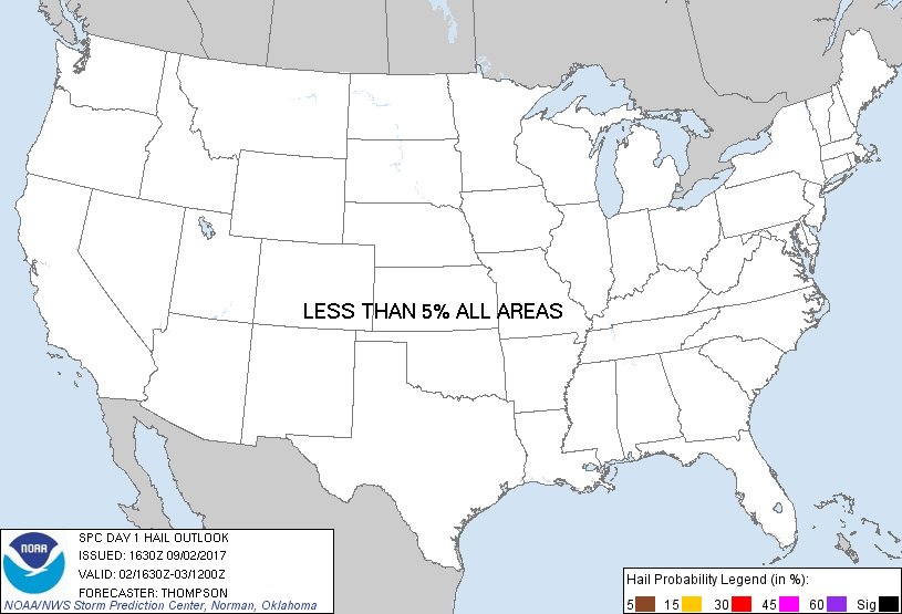
Probabilistic Large Hail Graphic
Probability of hail 1" or larger within 25 miles of a point. Hatched Area: 10% or greater probability of hail 2" or larger within 25 miles of a point.
Day 1 Hail Risk
Area (sq. mi.)
Area Pop.
Some Larger Population Centers in Risk Area
No Risk Areas Forecast
SPC AC 021630
Day 1 Convective Outlook
NWS Storm Prediction Center Norman OK
1130 AM CDT Sat Sep 02 2017
Valid 021630Z - 031200Z
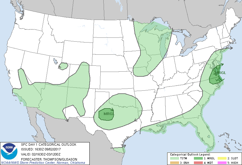
...THERE IS A MARGINAL RISK OF SEVERE THUNDERSTORMS THIS
AFTERNOON/EVENING FOR NORTHEASTERN NC INTO SOUTHEASTERN VA...
...THERE IS A MARGINAL RISK OF SEVERE THUNDERSTORMS THIS
AFTERNOON/EVENING FOR PARTS OF WEST TX...
...SUMMARY...
Isolated damaging wind gusts and perhaps a tornado could accompany
thunderstorms across portions of the Mid-Atlantic region today and
tonight. Isolated strong winds with thunderstorms will also be
possible this afternoon/evening across parts of west Texas.
...NC/VA through this evening...
The remnant circulation of Harvey will eject northeastward today
through tonight to the Mid Atlantic and southern New England, in
advance of an amplifying shortwave trough now over the upper Great
Lakes. A weak surface low will develop north-northeastward in
association with the ejecting midlevel trough, along a stalled front
from eastern NC into the VA Tidewater area. Widespread clouds and
rain this morning will slow surface heating along and east of the
front, with substantial cloud breaks not expected until mid-late
afternoon spreading northeastward across NC.
Given poor midlevel lapse rates and the morning clouds,
surface-based buoyancy will remain marginal through much of the day.
There may be a narrow window of opportunity for storm formation this
afternoon/evening along the front from northeastern NC into
southeastern VA, on the northeast edge of any cloud breaks.
Deep-layer vertical shear will be sufficient for some storm
organization, and a low-end threat for damaging gusts and perhaps a
brief/weak tornado.
...West central TX this afternoon/evening...
A midlevel shortwave trough is moving south-southeastward from the
TX Panhandle, along with a diffuse surface front/trough. It appears
there will be sufficient daytime heating, moisture, and ascent with
the wave to support scattered thunderstorm development this
afternoon across the Low Rolling Plains after about 21z, and storms
will subsequently move southward through late afternoon/evening.
Inverted-v profiles will support a low-end threat for damaging
outflow winds with these storms.
...MN Arrowhead/northern WI/western Upper MI this afternoon...
In the wake of morning elevated convection, some clearing is
expected from MN into WI and western Upper MI this afternoon.
Isolated thunderstorm development will be possible along a weak
surface cold front, though the front will lag the primary belt of
ascent preceding the associated midlevel trough. The 12z INL
sounding revealed steep lapse rates and the potential for low-topped
thunderstorms as the sampled environment spreads southeastward this
afternoon. While an isolated strong storm will be possible, the
threat for hail or wind gusts above severe thresholds appears too
marginal to warrant the addition of any probabilities.
..Thompson/Gleason.. 09/02/2017
CLICK TO GET WUUS01 PTSDY1 PRODUCT
NOTE: THE NEXT DAY 1 OUTLOOK IS SCHEDULED BY 2000Z