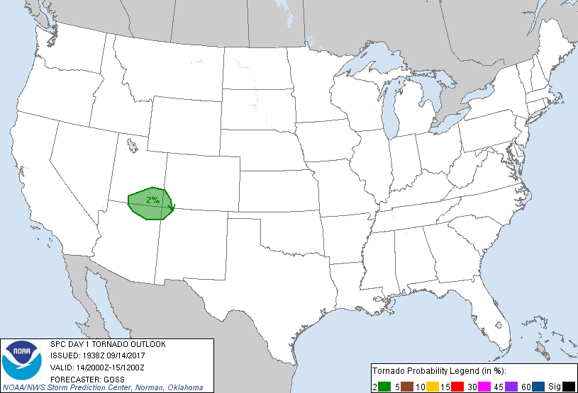
Probability of a tornado within 25 miles of a point. Hatched Area: 10% or greater probability of EF2 - EF5 tornadoes within 25 miles of a point.
Day 1 Tornado Risk
Area (sq. mi.)
Area Pop.
Some Larger Population Centers in Risk Area
2 %
27,610
181,680
Farmington, NM...Cortez, CO...
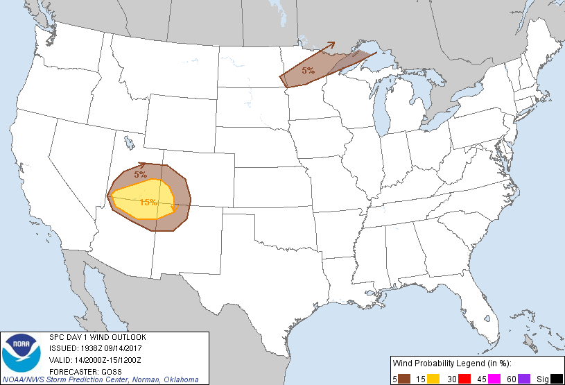
Probabilistic Damaging Wind Graphic
Probability of damaging thunderstorm winds or wind gusts of 50 knots or higher within 25 miles of a point. Hatched Area: 10% of greater probability of wind gusts 65 knots or greater within 25 miles of a point.
SPC AC 141938
Day 1 Convective Outlook
NWS Storm Prediction Center Norman OK
0238 PM CDT Thu Sep 14 2017
Valid 142000Z - 151200Z
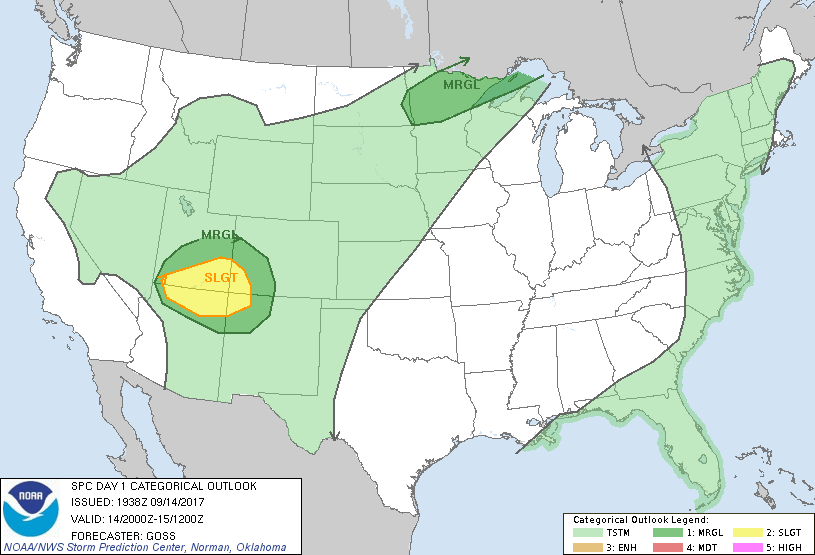
...THERE IS A SLIGHT RISK OF SEVERE THUNDERSTORMS ACROSS PORTIONS OF
THE FOUR CORNERS STATES...
...THERE IS A MARGINAL RISK OF SEVERE THUNDERSTORMS SURROUNDING THE
FOUR CORNERS SLIGHT RISK AREA...
...THERE IS A MARGINAL RISK OF SEVERE THUNDERSTORMS OVER PARTS OF
THE NORTH-CENTRAL U.S....
...SUMMARY...
Strong to severe storms may occur this afternoon and early evening
across the greater Four Corners region with locally damaging wind
and large hail the main threats. A few strong to severe storms with
hail and strong wind gusts are also possible from the eastern
Dakotas into northern Minnesota this evening and tonight.
...Discussion...
Latest model guidance and observations, as well as evolution of
ongoing convection, suggest that forecast reasoning from the prior
outlook remains valid. As such, excepting minor line adjustments,
no changes to the ongoing outlook appear necessary at this time.
Thunderstorms across the northern Arizona/southern Utah and into the
Four Corners region will continue to pose some risk for local severe
weather, while limited severe risk may possibly evolve over portions
of the north-central U.S. later tonight.
..Goss.. 09/14/2017
.PREV DISCUSSION... /ISSUED 1128 AM CDT Thu Sep 14 2017/
...Southwest US...
Water vapor loop shows an upper low tracking eastward across
southern CA. Large-scale forcing ahead of the low will continue to
spread eastward, promoting the development of scattered showers and
thunderstorms across parts of AZ/UT and eventually into western
CO/NM. Visible imagery shows that strong heating will occur in most
of this region, leading to steep low-level lapse rates this
afternoon. Surface dewpoints are rather low, but a pocket of
mid-level cooling associated with the upper low will help to yield
afternoon MUCAPE values of 500-1500 J/kg. Vertical shear is also
forecast to become favorable for organized or occasionally rotating
cells capable of hail and/or gusty winds. Please refer to Mesoscale
Discussion #1644 for further short-term details.
...MN...
A weak surface cold front remains across northern MN today.
Afternoon heating along the boundary coupled with dewpoints in the
60s will yield moderate CAPE values later today. Most 12z CAM
guidance shows multiple rounds of convection along and north of the
boundary this evening and tonight. A few of the more persistent
storms may produce hail and gusty winds. There was some
consideration for an upgrade to SLGT risk. However, it appears the
higher convective coverage will come after midnight, when
thermodynamic fields will be weakening. Therefore have chosen to
maintain the MRGL risk area.
CLICK TO GET WUUS01 PTSDY1 PRODUCT
NOTE: THE NEXT DAY 1 OUTLOOK IS SCHEDULED BY 0100Z