Deming, NM...Sunland Park, NM...Massena, NY...Silver City, NM...Presque Isle, ME...
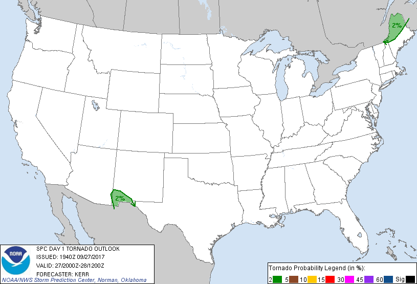
Probabilistic Tornado Graphic
Probability of a tornado within 25 miles of a point. Hatched Area: 10% or greater probability of EF2 - EF5 tornadoes within 25 miles of a point.
Day 1 Tornado Risk
Area (sq. mi.)
Area Pop.
Some Larger Population Centers in Risk Area
2 %
25,849
305,465
Deming, NM...Sunland Park, NM...Silver City, NM...Presque Isle, ME...Caribou, ME...
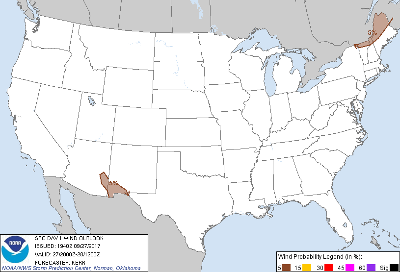
Probabilistic Damaging Wind Graphic
Probability of damaging thunderstorm winds or wind gusts of 50 knots or higher within 25 miles of a point. Hatched Area: 10% of greater probability of wind gusts 65 knots or greater within 25 miles of a point.
Day 1 Wind Risk
Area (sq. mi.)
Area Pop.
Some Larger Population Centers in Risk Area
5 %
34,588
539,275
El Paso, TX...Deming, NM...Sunland Park, NM...Massena, NY...Silver City, NM...
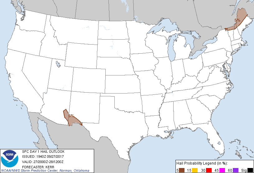
Probabilistic Large Hail Graphic
Probability of hail 1" or larger within 25 miles of a point. Hatched Area: 10% or greater probability of hail 2" or larger within 25 miles of a point.
Day 1 Hail Risk
Area (sq. mi.)
Area Pop.
Some Larger Population Centers in Risk Area
5 %
34,388
429,493
Deming, NM...Sunland Park, NM...Massena, NY...Silver City, NM...Presque Isle, ME...
SPC AC 271940
Day 1 Convective Outlook
NWS Storm Prediction Center Norman OK
0240 PM CDT Wed Sep 27 2017
Valid 272000Z - 281200Z
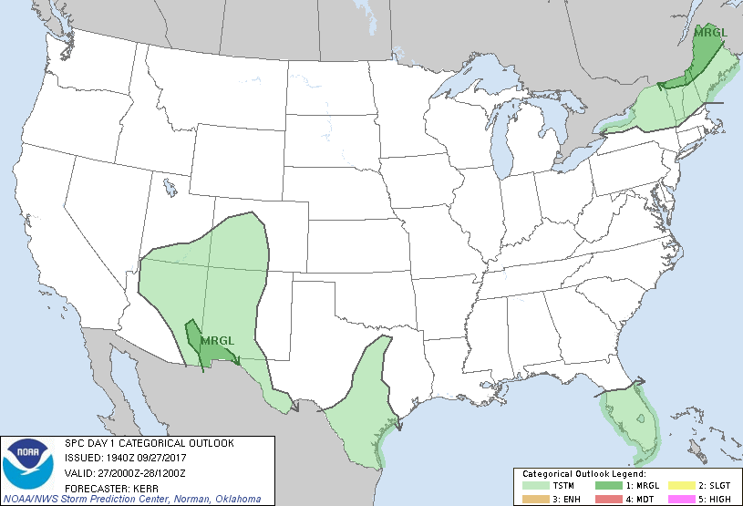
...THERE IS A MARGINAL RISK OF SEVERE THUNDERSTORMS LATE THIS
AFTERNOON OR EARLY EVENING ACROSS PARTS OF NORTHERN NEW ENGLAND...
...THERE IS A MARGINAL RISK OF SEVERE THUNDERSTORMS ACROSS PARTS OF
SOUTHWESTERN NEW MEXICO INTO SOUTHEASTERN ARIZONA...
...SUMMARY...
Marginal risks for severe thunderstorms exist this afternoon into
early evening, over parts of northern New England, eastern Arizona
and southwestern New Mexico.
...20Z Outlook Update...
Adjustments to the categorical and probabilistic outlook lines have
been made, mostly in an attempt to better account for ongoing trends
evident in the latest observational data. Perhaps the most notable
change is the reduction in thunderstorm probabilities below the
categorical (10 percent) threshold across much of Texas and adjacent
areas of the south central United States.
Cool/stable low-level air has overspread most of the high Plains to
the lee of the southern Rockies, where mid-tropospheric lapse rates
are also generally weak and unlikely to destabilize appreciably
through the remainder of this period. Moist, potentially unstable
boundary layer air is largely confined to Deep South Texas, where
scattered thunderstorm activity is ongoing. A categorical thunder
outlook is also being maintained within a narrow corridor roughly
along the I-35 corridor of central Texas. Despite weak low-level
convergence in the presence of general surface ridging, weak
destabilization is evident within a zone of stronger differential
surface heating across this region. Ongoing convection near the
Dallas/Forth Worth metroplex has recently support lightning, and
this could continue into early evening.
..Kerr.. 09/27/2017
.PREV DISCUSSION... /ISSUED 1114 AM CDT Wed Sep 27 2017/
...ME/NH/VT...
Water vapor imagery shows a strong shortwave trough moving across
Ontario. Lift ahead of this system is expected to result in
scattered afternoon/evening showers and thunderstorms moving from
Quebec into northern New England. Strong heating is occurring in
this area, with afternoon MLCAPE values expected to exceed 500 J/kg.
Forecast soundings show favorable deep layer vertical shear for
rotating/bowing storm structures and the chance of damaging wind
gusts in the stronger cells - mainly after dark. The primary
factors that will likely limit a more robust severe event are poor
lapse rates and only marginal instability. Given 12z CAM guidance,
parts of far northern ME have the greatest risk of more organized
severe storms. However, will maintain the MRGL risk category due to
the very limited area of concern.
...NM/AZ...
An upper low continues to affect the southwest US, with deep
southwesterly flow aloft across parts of NM/AZ. The threat of
isolated strong/severe will develop again this afternoon along a
weak baroclinic zone that is slowly moving westward across the
region. Similar to the last several days, a storm or two may
produce hail and/or gusty winds later today, but coverage should be
sparse.
CLICK TO GET WUUS01 PTSDY1 PRODUCT
NOTE: THE NEXT DAY 1 OUTLOOK IS SCHEDULED BY 0100Z