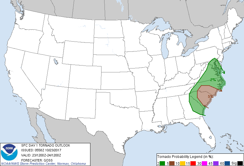
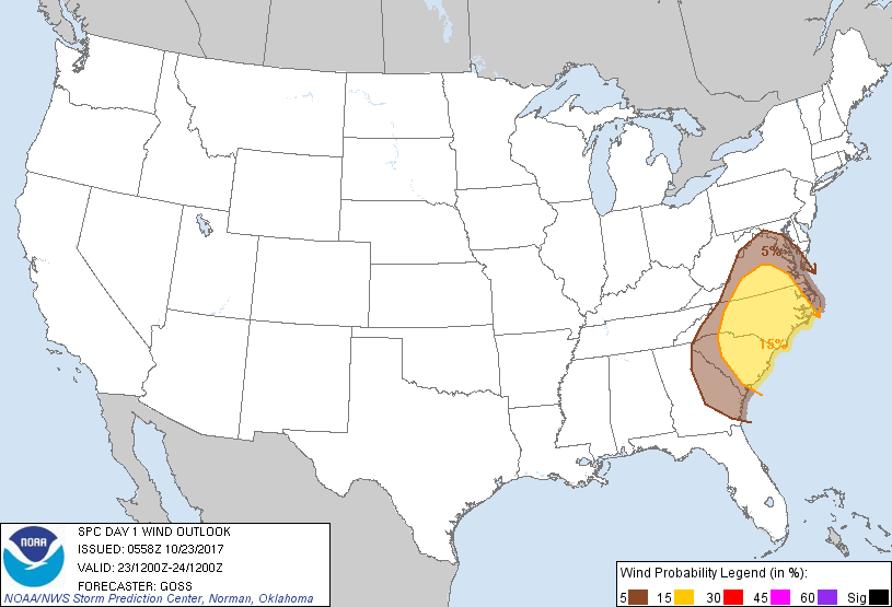
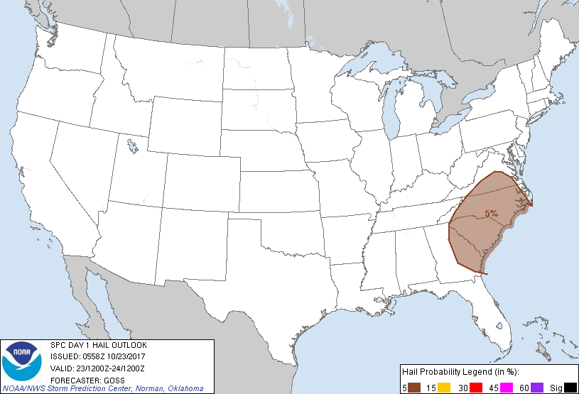
Baltimore, MD...Washington, DC...Virginia Beach, VA...Raleigh, NC...Norfolk, VA...
Probabilistic Damaging Wind Graphic
Probability of damaging thunderstorm winds or wind gusts of 50 knots or higher within 25 miles of a point. Hatched Area: 10% of greater probability of wind gusts 65 knots or greater within 25 miles of a point.
SPC AC 230558
Day 1 Convective Outlook
NWS Storm Prediction Center Norman OK
1258 AM CDT Mon Oct 23 2017
Valid 231200Z - 241200Z
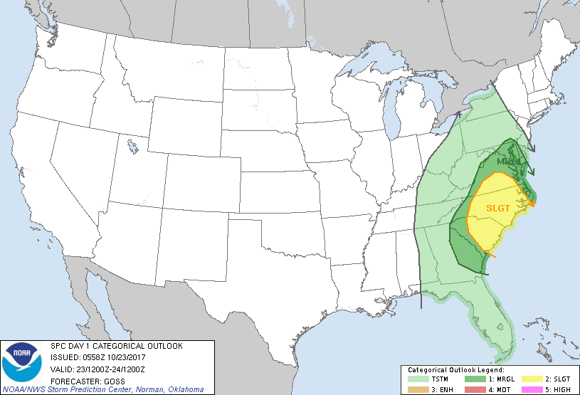
...THERE IS A SLIGHT RISK OF SEVERE THUNDERSTORMS ACROSS PORTIONS OF
THE CAROLINAS AND INTO CENTRAL VIRGINIA...
...THERE IS A MARGINAL RISK OF SEVERE THUNDERSTORMS FROM THE
DELMARVA AREA SOUTH TO SOUTHEAST GEORGIA AND WEST TO THE
APPALACHIANS...
...SUMMARY...
Strong/locally severe storms are expected from eastern Georgia to
the Mid-Atlantic Monday afternoon into the overnight hours. The
primary threat will be damaging wind gusts, along with potential for
a few tornadoes.
...Synopsis...
A large upper cyclone with broad/surrounding cyclonic flow is
progged to become established across the central and eastern U.S.
today and tonight. This will occur as two features -- a low moving
across the mid MS/lower OH/TN Valleys early in the period and a
short-wave trough digging southeast across the northern and central
Plains -- gradually coalesce into one larger-scale low. Either side
of this large low/trough, highly amplified ridges will likewise
evolve -- one gradually encompassing much of the West, and a second
extending from the western Atlantic north across New England into
eastern Canada.
At the surface...low pressure initially over the Tennessee Valley
area is forecast to shift northward and deepen substantially with
time, reaching the upper Great Lakes as a 985 mb low early Tuesday
morning. As the low deepens northward, a trailing cold front is
forecast to shift east across the southern and central Appalachians
through the afternoon, and reaching the middle and southern Atlantic
coasts and crossing north Florida late in the period.
...Portions of Virginia/the Carolinas and surrounding areas...
Scattered to widespread showers and thunderstorms are expected to be
ongoing near/ahead of the front at the start of the period over the
mid South and Southeast, spreading northeastward with time into the
Carolinas and Virginia prior to frontal passage. Models exhibit
substantial differences regarding coverage of the pre-frontal
convection, but at this time it appears that the degree of
cloudiness/precipitation will be substantial enough to maintain weak
lapse rates and hinder diurnal heating to at least some degree. As
such, CAPE will likely remain limited in many areas to around 500
J/kg or less -- and in turn therefore limiting overall intensity of
convection/degree of severe risk.
With that said, shear profiles should gradually strengthen across
the region, likely becoming quite supportive of rotating updrafts,
as 40 to 50 kt southwesterly flow at mid levels spreads atop
isallobarically backed/enhanced low-level southeasterlies. Thus --
with favorable shear but uncertainty with respect to available
instability, the severe forecast remains conditional upon initiation
of deeper/robust updrafts.
At this time, it appears that focused ascent near the front itself
may promote a band of stronger/forced updrafts on the western edge
of ongoing/scattered pre-frontal convection. While some tornado
risk will exist within the stronger pre-frontal cells, greater
severe potential -- to include damaging winds in addition to a few
tornadoes -- will likely evolve within the frontal convective band.
This band should evolve/intensify by early to mid afternoon, and
then shift northeastward across the mid-Atlantic and southeast
states through the evening and into the overnight hours. Some risk
for wind -- with a narrow band of frontal convection that may
produce little lightning -- may spread across the central
Appalachians and possibly north of the Mason/Dixon line overnight,
though greatest severe threat should reside over the Carolinas and
parts of Virginia as indicated by the slight risk area until
convection gradually weakens -- and eventually moves offshore --
through latter stages of the period.
..Goss.. 10/23/2017
CLICK TO GET WUUS01 PTSDY1 PRODUCT
NOTE: THE NEXT DAY 1 OUTLOOK IS SCHEDULED BY 1300Z