Jacksonville, FL...Baltimore, MD...Washington, DC...Virginia Beach, VA...Raleigh, NC...
Probabilistic Damaging Wind Graphic
Probability of damaging thunderstorm winds or wind gusts of 50 knots or higher within 25 miles of a point. Hatched Area: 10% of greater probability of wind gusts 65 knots or greater within 25 miles of a point.
Jacksonville, FL...Baltimore, MD...Washington, DC...Virginia Beach, VA...Norfolk, VA...
Probabilistic Large Hail Graphic
Probability of hail 1" or larger within 25 miles of a point. Hatched Area: 10% or greater probability of hail 2" or larger within 25 miles of a point.
Day 1 Hail Risk
Area (sq. mi.)
Area Pop.
Some Larger Population Centers in Risk Area
No Risk Areas Forecast
SPC AC 231252
Day 1 Convective Outlook
NWS Storm Prediction Center Norman OK
0752 AM CDT Mon Oct 23 2017
Valid 231300Z - 241200Z
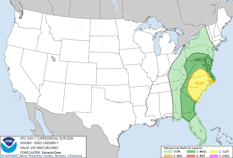
...THERE IS A SLIGHT RISK OF SEVERE THUNDERSTORMS OVER PARTS OF THE
CAROLINAS AND VIRGINIA...
...THERE IS A MARGINAL RISK OF SEVERE THUNDERSTORMS ELSEWHERE FROM
NORTHERN FLORIDA TO THE MID-ATLANTIC REGION...
...SUMMARY...
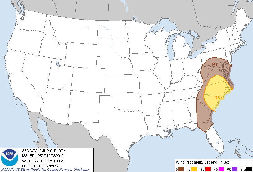
Severe storms are possible from northern Florida to the Mid-Atlantic
this afternoon and evening. The primary threat will be damaging
wind gusts, along with potential for a few tornadoes.
...Synopsis...
Mean mid/upper troughing over the eastern U.S. will be reinforced
with major cyclogenesis late in the period and into day 2. A
strong, negatively tilted shortwave trough -- currently containing a
500-mb low near the MO Bootheel -- will eject northeastward then
northward across the mid/upper OH Valley and Lake Erie today and
tonight. Meanwhile, a northern-stream perturbation -- now evident
in moisture-channel imagery over northwestern MN and SD -- will
amplify greatly as it digs southeastward, reaching IA and MO by 00Z
and forming a closed low over IL tonight. By 12Z, a large cyclone
should cover much of the U.S. from the Plains eastward, with a
temporary double center -- one over eastern Upper MI and the other
near the IL/IN border.
At the surface, 11Z analysis showed a frontal-wave cyclone over
western/southern IN, with cold front extending to middle TN, eastern
AL, the western FL Panhandle, and the central Gulf. A warm front
was drawn from extreme southern coastal NC westward over central/
western SC, becoming diffuse in an area of convection and precip
over northern GA and eastern TN. The surface cyclone should deepen
and occlude as it follows a curved path across eastern Lower MI to
near the eastern end of Lake Superior by 12Z. The surface cold
front is forecast to reach WV, the western Carolinas, central/
eastern GA and the eastern Gulf by 00Z. By 12Z, the cold front
should reach central NY, eastern PA, eastern NC, and the northern/
western FL peninsula. The warm front should become more diffuse as
it shifts rapidly northward through the Carolinas, VA and portions
of the Mid-Atlantic region through this evening.
...Northern FL to Mid-Atlantic region...
A band of thunderstorms should develop near the surface cold front
and sweep east-northeastward across the outlook area today, with
damaging gusts and a few tornadoes possible. Isolated damaging
gusts are possible with a more conditional tornado risk accompanying
convection in an extensive prefrontal corridor.
A roughly 150-nm-wide plume of prefrontal convection, precip and
thick cloud cover are apparent at this time, from eastern TN
southward across much of GA and the central/eastern FL Panhandle to
the northeastern Gulf. This plume and associated/downstream
mid/upper-level cloud cover will substantially impede insolation
over much of the warm sector today, rendering weak boundary-layer
lapse rates in many areas. Still, a combination of subtle/diffuse
diabatic heating, low-level theta-e advection and weak MLCINH should
result in adequate buoyancy for surface-based convection, amidst
northward expansion of rich low-level moisture. These factors will
offset modest mid/upper-level lapse rate enough for 1000-1500 J/kg
MLCAPE over parts of northern FL, 500-1000 J/kg MLCAPE as far north
as the Carolinas, and 100-500 J/kg possible northward toward parts
of central/eastern VA and the Delmarva region this evening.
Strengthening deep-layer wind fields are expected over the warm
sector today as the height gradient aloft tightens east of the
deepening mean trough, and the lower/middle Mississippi Valley
shortwave trough ejects northeastward. This will create a
low-CAPE/high-shear scenario from the Carolinas northward, with
lesser (but still adequate) shear and larger CAPE over parts of
southern/eastern GA and northern FL.
The northern end of the main convective band likely will be manifest
as a narrow, strongly forced ribbon of low-topped convection with
little or no lightning -- already evident in non-severe form above a
relatively stable surface air mass over portions of KY and TN. This
band should develop further and accelerate northeastward across the
central Appalachians today. Forecast soundings generally show only
minor variations in lapse rates and low-level theta-e; however,
those variations occur across neutral stability. As often is true
in near-neutral profile scenarios, very minor shifts -- often below
model-predictability limits and spatially poorly sampled by
upper-air thermodynamic observations -- may differentiate between
profiles with unsupportive conditional stability and those with deep
(albeit low-density) CAPE. As such, considerable uncertainty exists
regarding how far north a truly convective wind-damage risk exists
over the WV/PA/western MD region. Still, enough progs indicate
neutral to very weakly unstable lapse rates that some northward
expansion of the marginal convective-wind risk probably is
warranted. Forecast mean-wind and deep-shear vectors are strong,
but largely parallel to the boundary instead of orthogonal, as would
represent a more optimal convective wind setup.
..Edwards/Dean.. 10/23/2017
CLICK TO GET WUUS01 PTSDY1 PRODUCT
NOTE: THE NEXT DAY 1 OUTLOOK IS SCHEDULED BY 1630Z