Nov 22, 2017 0600 UTC Day 1 Convective Outlook
Updated: Wed Nov 22 04:43:58 UTC 2017 (20171122 1200Z Day 1 shapefile | 20171122 1200Z Day 1 KML)
Probabilistic to Categorical Outlook Conversion Table
Categorical Graphic
20171122 1200 UTC Day 1 Outlook Graphic
Day 1 Risk Area (sq. mi.) Area Pop. Some Larger Population Centers in Risk Area
No Risk Areas Forecast
Probabilistic Tornado Graphic
20171122 1200 UTC Day 1 Tornado Probabilities Graphic
Probability of a tornado within 25 miles of a point.
Hatched Area: 10% or greater probability of EF2 - EF5 tornadoes within 25 miles of a point.
Day 1 Tornado Risk Area (sq. mi.) Area Pop. Some Larger Population Centers in Risk Area
No Risk Areas Forecast
Probabilistic Damaging Wind Graphic
20171122 1200 UTC Day 1 Damaging Wind Probabilities Graphic
Probability of damaging thunderstorm winds or wind gusts of 50 knots or higher within 25 miles of a point.
Hatched Area: 10% of greater probability of wind gusts 65 knots or greater within 25 miles of a point.
Day 1 Wind Risk Area (sq. mi.) Area Pop. Some Larger Population Centers in Risk Area
No Risk Areas Forecast
Probabilistic Large Hail Graphic
20171122 1200 UTC Day 1 Large Hail Probabilities Graphic
Probability of hail 1" or larger within 25 miles of a point.
Hatched Area: 10% or greater probability of hail 2" or larger within 25 miles of a point.
Day 1 Hail Risk Area (sq. mi.) Area Pop. Some Larger Population Centers in Risk Area
No Risk Areas Forecast
   SPC AC 220443

   Day 1 Convective Outlook  
   NWS Storm Prediction Center Norman OK
   1043 PM CST Tue Nov 21 2017

   Valid 221200Z - 231200Z

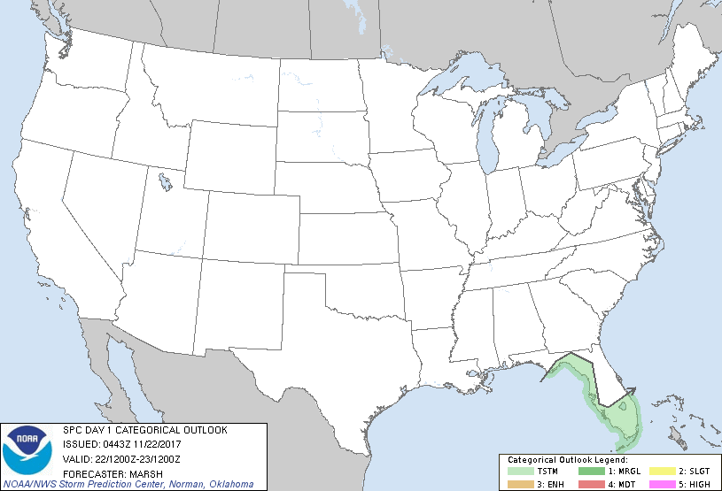
   ...NO SEVERE THUNDERSTORM AREAS FORECAST...

   ...SUMMARY...
   An isolated thunderstorm will be possible on Wednesday across south
   Florida, with additional thunderstorm chances late Wednesday night
   across the Florida Big Bend. Severe weather is not expected with
   either scenario.

   ...Discussion...

   An amplified mid-level pattern will persist across the United States
   on Wednesday, with mean ridging across the West and mean troughing
   across the East. The axis of mean troughing will result in broad
   southwest flow stretching from the Florida Peninsula to the eastern
   Canadian provinces. Embedded within this flow, one mid-level trough
   will quickly lift northward along the east coast, with another
   moving over the Gulf of Mexico.

   Given the broad southwest flow atop a warm, moist boundary layer, an
   isolated thunderstorm may develop across south Florida during the
   day on Wednesday. Despite sufficient mid-upper-level shear profiles,
   modest low-level flow should preclude a severe risk. Additionally,
   thunderstorms should develop/continue across the Gulf of Mexico
   through most of the day as the mid-level trough slowly moves east.
   These thunderstorms should begin to approach the Florida Big Bend by
   late Wednesday night and early Thursday morning.

   ..Marsh.. 11/22/2017

   CLICK TO GET WUUS01 PTSDY1 PRODUCT

   NOTE: THE NEXT DAY 1 OUTLOOK IS SCHEDULED BY 1300Z