Lubbock, TX...Amarillo, TX...Garden City, KS...North Platte, NE...Plainview, TX...
MARGINAL
99,901
1,045,708
Midland, TX...Odessa, TX...Grand Island, NE...Clovis, NM...Kearney, NE...
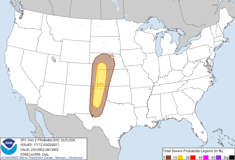
Probabilistic Graphic
Probability of severe weather within 25 miles of a point. Hatched Area: 10% or greater probability of significant severe within 25 miles of a point.
Day 2 Prob. Risk
Area (sq. mi.)
Area Pop.
Some Larger Population Centers in Risk Area
15 %
64,587
1,036,095
Lubbock, TX...Amarillo, TX...Garden City, KS...North Platte, NE...Plainview, TX...
5 %
100,075
1,048,878
Midland, TX...Odessa, TX...Grand Island, NE...Clovis, NM...Kearney, NE...
   SPC AC 221717

   Day 2 Convective Outlook
   NWS Storm Prediction Center Norman OK
   1217 PM CDT Wed Mar 22 2017

   Valid 231200Z - 241200Z

   ...THERE IS A SLIGHT RISK OF SEVERE THUNDERSTORMS FROM A PORTION OF
   WESTERN TEXAS THROUGH EXTREME EASTERN COLORADO...WESTERN KANSAS AND
   SOUTHWEST NEBRASKA...

   ...THERE IS A MARGINAL RISK OF SEVERE THUNDERSTORMS OVER THE
   SOUTHERN THROUGH CENTRAL HIGH PLAINS...

   ...SUMMARY...
   Thunderstorms will pose a threat for large hail, damaging wind gusts
   and perhaps a couple of tornadoes in parts of the southern through
   central High Plains Thursday evening.

   ...Central through southern High Plains region...

   Upper trough approaching the CA coast as of mid day Wednesday will
   reach the central and southern High Plains Thursday evening. Lee
   cyclogenesis will commence early Wednesday, and the low will deepen
   over eastern CO within exit region of an upper jet max rotating
   through the base of the upper trough. The resulting strengthening
   low-level jet will advect modified continental-polar air with middle
   to upper 50s F dewpoints through the high plains beneath plume of
   steep lapse rates contributing to 1000-1500 J/kg MLCAPE during the
   afternoon. The atmosphere will likely remain capped most of the day.
   However, storms should develop from eastern NM and CO into western
   TX and KS by early evening as deep forcing for ascent accompanying
   the progressive shortwave trough overtakes the sharpening dryline.
   Strong 50+ kt sfc-6 km shear will support supercells with large hail
   and isolated damaging wind the main threats. However, 0-1 km
   hodograph size will increase during the early evening as the
   low-level jet strengthens, suggesting at least a small window of
   opportunity for  a couple of tornadoes before the boundary layer
   begins to stabilize. Additional storms may develop farther east
   later Thursday night from west central through north central Texas,
   but the thermodynamic environment is not expected to be sufficient
   for a severe threat.

   ..Dial.. 03/22/2017

   CLICK TO GET WUUS02 PTSDY2 PRODUCT

   NOTE: THE NEXT DAY 2 OUTLOOK IS SCHEDULED BY 0600Z