San Antonio, TX...Dallas, TX...Fort Worth, TX...New Orleans, LA...Arlington, TX...
5 %
116,440
5,612,530
Memphis, TN...Laredo, TX...Little Rock, AR...Brownsville, TX...Abilene, TX...
SPC AC 011734
Day 2 Convective Outlook
NWS Storm Prediction Center Norman OK
1234 PM CDT Sat Apr 01 2017
Valid 021200Z - 031200Z
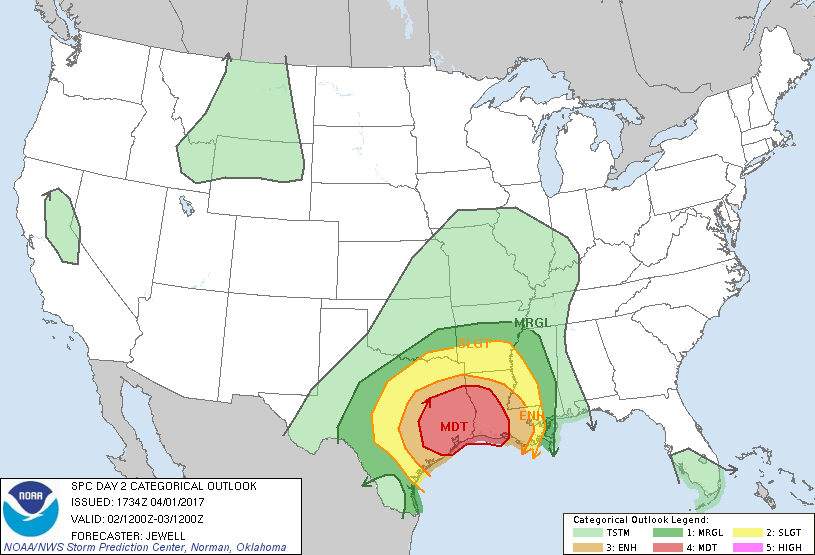
...THERE IS A MODERATE RISK OF SEVERE THUNDERSTORMS ACROSS EASTERN
TEXAS INTO WESTERN LOUISIANA...
...THERE IS AN ENHANCED RISK OF SEVERE THUNDERSTORMS OVER MOST OF
EASTERN TEXAS INTO LOUISIANA...
...THERE IS A SLIGHT RISK OF SEVERE THUNDERSTORMS FROM CENTRAL TEXAS
ACROSS THE ARKLATEX AND INTO THE LOWER MISSISSIPPI VALLEY...
...THERE IS A MARGINAL RISK OF SEVERE THUNDERSTORMS FROM TEXAS INTO
MISSISSIPPI...
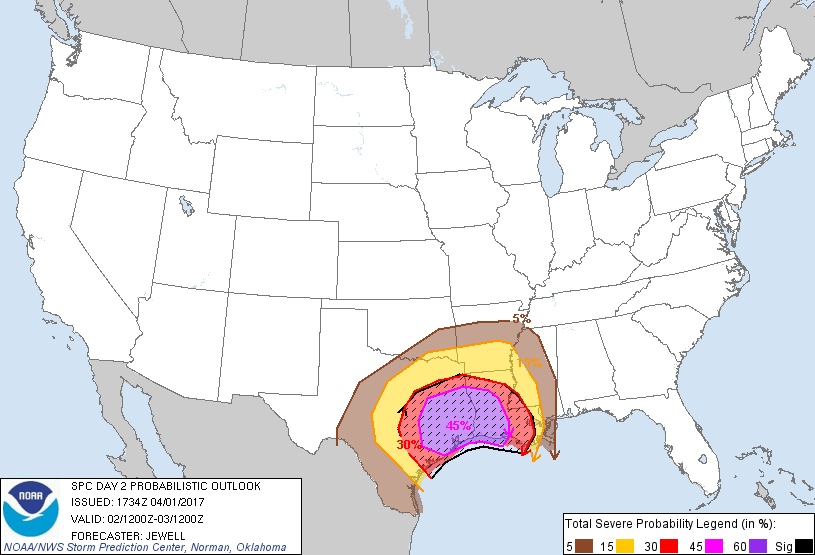
...SUMMARY...
Dangerous severe thunderstorms capable of strong tornadoes,
extensive wind damage and hail are possible beginning Sunday morning
east of I-35 in Texas and developing eastward across Louisiana
throughout the day and into the night. Severe storms are also
possible across the Arklatex during the day and into western
Mississippi by Monday morning.
...Synopsis...
Low pressure will gradually translate northeastward through the
period with a cold front to the west, from the lower Rio Grande
Valley Sunday morning into Arkansas by Monday morning. Ahead of the
low, a warm front will rapidly lift northward across east Texas
toward the Arklatex and extend into southern Mississippi by 00Z.
Across the warm sector, a very moist and unstable air mass will
exist, characterized by upper 60s to near 70 dewpoints, beneath
cooling profiles aloft and steep midlevel lapse rates. This volatile
air mass will exist over a large area, suggesting potential for
widespread severe weather.
Both mid and high-level southwesterly flow aloft will increase
throughout the period as the upper trough moves northeastward across
TX. The northward transport of moisture and instability will be
aided by a broad, southerly low-level jet which will increase to 50
kt by late afternoon and will shift eastward across the lower MS
valley overnight. This will create strong, veering winds with height
which will clearly favor significant severe thunderstorms including
tornadic supercells, damaging bows, and quasi-linear convective
systems. The severe threat is expected to begin by mid morning
across central and northern Texas, and evolve/expand eastward
through the rest of the period to near the Mississippi river by 12Z
Monday.
...Central into northeast Texas and across the Arklatex -- Sunday
morning through afternoon...
Model consensus is that supercells may begin forming in the 12-15Z
time frame from near Austin TX to just east of Dallas, aided by
convergence within the low pressure trough and where rapid moisture
advection will be underway. Any capping inversion is expected to be
minor, and relatively low for this part of Texas. This suggests that
early development is indeed feasible, and increases the chances of
strong low-level accelerations in the storms as opposed to
situations where the LFC is much higher. The cells may take some
time to become better organized as the low level jet will be on the
increase during the day. However, by 18-21Z, these storms should
pose a tornado and wind threat across northeast TX approaching the
Arklatex, with strong tornadoes possible. CAMs suggest that
supercells may eventually merge into an MCS, in which case damaging
straight-line winds would be likely. In addition, re-generation of
supercells is possible along the southern fringe or along any
outflow boundary laid out by this earlier activity, possibly
affecting areas along the northern edge of the Moderate Risk area
such as Shreveport LA.
...East Texas into Louisiana -- Midday through evening...
The fast erosion of any capping inversion Sunday morning and
widespread destabilization of the air mass lends uncertainty to
exact placement and timing of tornadic supercell development, with a
potential extending from east TX to New Orleans, and timing anywhere
from midday through evening across the warm sector. Some models such
as the ECMWF produce storms over southeastern LA during day, and the
environment would already be favorable for tornadoes. However, the
most likely scenario is for supercells to begin developing by
midday, near the warm front and intensifying low-level jet core
which will be across east TX into western LA, then eventually
spreading eastward as the cold front approaches from the west. At
least a few strong tornadoes are expected given large looping
hodographs with effective SRH in excess of 300 m2/s2 along with
impressive instability profiles. Overnight, cells may merge into a
QLCS, with both tornado and damaging wind threat persisting into
Monday morning.
..Jewell.. 04/01/2017
CLICK TO GET WUUS02 PTSDY2 PRODUCT
NOTE: THE NEXT DAY 2 OUTLOOK IS SCHEDULED BY 0600Z