Oklahoma City, OK...New Orleans, LA...Wichita, KS...Birmingham, AL...Baton Rouge, LA...
SPC AC 031736
Day 2 Convective Outlook
NWS Storm Prediction Center Norman OK
1236 PM CDT Mon Apr 03 2017
Valid 041200Z - 051200Z
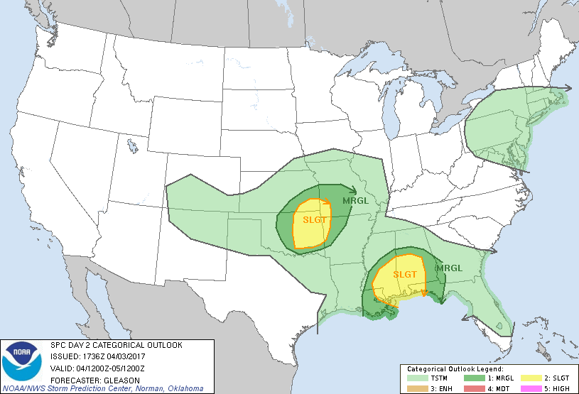
...THERE IS A SLIGHT RISK OF SEVERE THUNDERSTORMS ACROSS PARTS OF
CENTRAL/EASTERN OK TO THE OZARKS...
...THERE IS A SLIGHT RISK OF SEVERE THUNDERSTORMS ACROSS PARTS OF
THE CENTRAL GULF COAST STATES...
...THERE IS A MARGINAL RISK OF SEVERE THUNDERSTORMS ACROSS PARTS OF
THE CENTRAL/SOUTHERN PLAINS...
...THERE IS A MARGINAL RISK OF SEVERE THUNDERSTORMS ACROSS PARTS OF
THE CENTRAL GULF COAST STATES...
...SUMMARY...
Isolated severe thunderstorms will be possible across parts of the
south central Plains into the Ozarks Tuesday afternoon into Tuesday
night, and across parts of the central Gulf Coast states late
Tuesday night into early Wednesday morning.
...Synopsis...
As one shortwave trough over the OH Valley and Mid-Atlantic moves
northeastward across New England, another shortwave trough across
the central/southern Rockies will develop eastward over the
central/southern Plains through Tuesday evening. At the surface, a
low initially centered across the southern High Plains will develop
northeastward towards the Ozarks while deepening through the period.
A separate surface low over the eastern Great Lakes region will move
northeastward into Canada, while an associated cold front moves off
the East Coast and into the western Atlantic. The front will stall
over the northern Gulf of Mexico and lift northward as a warm front
late Tuesday into early Wednesday.
...South Central Plains into the Ozarks...
Due to a prior frontal passage, low-level moisture will remain
limited across much of the central/southern Plains though Tuesday
evening. Regardless, steepening mid-level lapse rates and
strengthening low and mid-level winds associated with the shortwave
trough approaching from the west will foster a sufficient
combination of instability and effective shear to support supercells
structure across this region Tuesday afternoon/evening. The best
chance for surface-based development should be across mainly eastern
OK into southeastern KS, southwestern MO, and perhaps western AR
ahead of the deepening surface low and attendant eastward-moving
cold front. Large hail and damaging wind gusts appear to be the main
threats, with a lessening of the overall severe threat expected with
eastward extent into central MO/AR Tuesday evening due to
increasingly marginal instability.
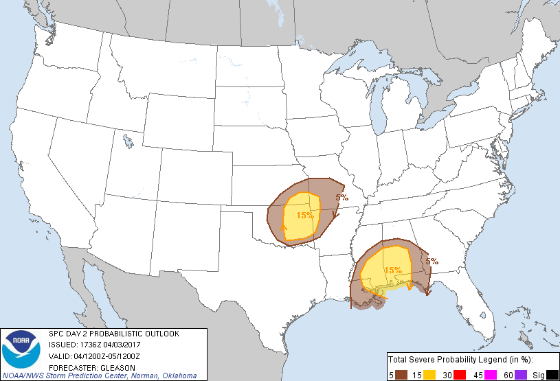
...Central Gulf Coast States...
As low-level mass response occurs ahead of the central/southern
Plains shortwave trough, a warm front will lift northward across the
central Gulf Coast States late Tuesday night into early Wednesday
morning. Forecast soundings suggest any thunderstorms that occur
along and south of the warm front may be surface based due to rich
low-level moisture present across the northern Gulf streaming
northward. A strengthening wind profile would conditionally support
supercells posing a threat for all severe hazards, including
isolated tornadoes. Although convective precipitation coverage in
latest guidance are mixed regarding this potential, there is enough
of a signal to increase severe probabilities to Slight Risk.
..Gleason.. 04/03/2017
CLICK TO GET WUUS02 PTSDY2 PRODUCT
NOTE: THE NEXT DAY 2 OUTLOOK IS SCHEDULED BY 0600Z