SPC AC 250558
Day 2 Convective Outlook
NWS Storm Prediction Center Norman OK
1258 AM CDT Tue Apr 25 2017
Valid 261200Z - 271200Z
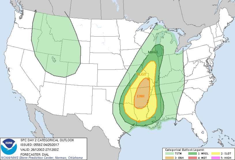
...THERE IS AN ENHANCED RISK OF SEVERE THUNDERSTORMS OVER A PORTION
OF THE LOWER TO MIDDLE MISSISSIPPI VALLEY REGION...
...THERE IS A SLIGHT RISK OF SEVERE THUNDERSTORMS FROM A PORTION OF
THE SOUTHERN PLAINS INTO A PORTION OF THE MIDWEST...
...THERE IS A MARGINAL RISK OF SEVERE THUNDERSTORMS FROM A PORTION
OF THE SOUTHERN PLAINS INTO THE GREAT LAKES...
...SUMMARY...
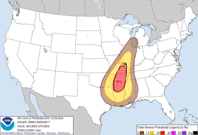
Severe thunderstorms with large hail, damaging wind and possibly a
few tornadoes are expected across parts of the Arklatex and lower to
mid Mississippi Valley Wednesday. Isolated severe thunderstorms will
be possible from Illinois into the southwestern Great Lakes region.
...Synopsis...
Model consensus is that an upper trough will amplify over the
southern Plains early Wednesday, becoming negatively tilted and
continuing through the Mississippi Valley Wednesday evening and
overnight. A lower-amplitude shortwave trough will precede this
feature and should be located over the upper MS valley at the
beginning of this period.
By 12Z Wednesday a cold front should extend from a surface low over
the upper MS Valley southwestward through northwest TX with a
dryline farther south through central and southern TX. The cold
front will continue east and southeast during the day, reaching the
Great Lakes through TN Valley region Wednesday night.
...Southern Plains and lower to middle Mississippi Valley...
Strengthening low-level jet induced by the approaching shortwave
trough will advect mid to upper 60s F boundary-layer dewpoints
through the pre-frontal warm sector beneath 7-7.5 C/km mid-level
lapse rates. These processes will contribute to moderate instability
with 1500-2500 J/kg MLCAPE, despite the potential for widespread low
clouds which will limit diabatic warming in some areas.
Thunderstorms will likely be in progress within baroclinic zone and
along warm conveyor belt from portions of OK into MO, and some of
this activity could pose an ongoing modest risk for a few strong
wind gusts and hail. However, primary development of severe storms
is expected during the afternoon as storms intensify along and just
ahead of the cold front and in association with a destabilizing warm
sector. Strong dynamic forcing for ascent within frontal zone
augmented by the negatively tilted shortwave trough and
strengthening low-level jet will likely result in the initiation of
numerous storms and an eventual upscale linear growth. Strong
deep-layer winds, vertical shear and large low-level hodographs will
favor organized storms including embedded supercells and bowing
segments, with all severe hazards possible.
...Illinois into the Great Lakes...
Instability and low-level moisture will be less in this region
compared to farther south but sufficient for an organized severe
threat given favorable wind profiles. The stronger storms will
likely expand into this region during the late afternoon and
evening, with a few supercells and bowing linear segments capable of
damaging wind, large hail and a couple of tornadoes.
..Dial.. 04/25/2017
CLICK TO GET WUUS02 PTSDY2 PRODUCT
NOTE: THE NEXT DAY 2 OUTLOOK IS SCHEDULED BY 1730Z