SPC AC 251730
Day 2 Convective Outlook
NWS Storm Prediction Center Norman OK
1230 PM CDT Tue Apr 25 2017
Valid 261200Z - 271200Z
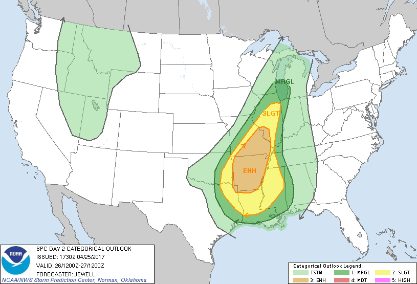
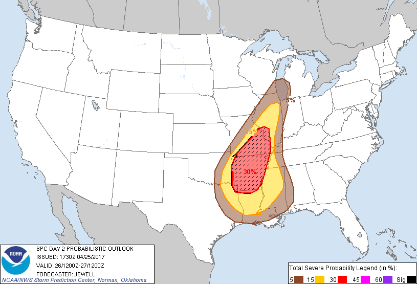
...THERE IS AN ENHANCED RISK OF SEVERE THUNDERSTORMS ACROSS ARKANSAS
AND INTO SOUTHERN MISSOURI AND SOUTHWEST ILLINOIS...
...THERE IS A SLIGHT RISK OF SEVERE THUNDERSTORMS FROM THE ARKLATEX
AND LOWER MISSISSIPPI VALLEY NORTHWARD INTO ILLINOIS...
...THERE IS A MARGINAL RISK OF SEVERE THUNDERSTORMS IMMEDIATELY
SURROUNDING THE SLIGHT RISK AREA...
...SUMMARY...
Severe thunderstorms with damaging winds, a few tornadoes and some
hail are expected across much of Arkansas and southern Missouri
Wednesday. Isolated severe thunderstorms with damaging wind are also
expected across Illinois during the day and across the lower
Mississippi Valley overnight.
...Synopsis...
A potent shortwave trough will move from the southern Plains
northeastward across the middle MS valley with a surface trough
extending from WI into AR at 00Z. Strong large-scale lift will exist
resulting in widespread strong to severe thunderstorm activity
throughout the day. The most intense storms are expected over AR
and across southern MO, beneath strong southwesterly flow aloft with
activity focused along the advancing front. All modes of severe will
be possible, with damaging wind the most prominent threat. A few
strong bows may trek northeastward across much of Illinois as well.
Southern portions of this front will progress across the lower MS
valley overnight, focusing a damaging wind threat into MS and
western TN with a slowly decreasing threat with eastward extent.
...Arklatex northeastward across Illinois...
Storms are expected to be ongoing Wednesday morning along an
outflow/front composite boundary extending from eastern OK into
southwest MO. This activity should be elevated with hail, but
damaging wind will also be possible with storms right on the
boundary. With time, lift along the front will intensify as cooling
aloft overspreads the area and the air mass destabilizes further.
Strong mean winds and linear forcing suggest damaging serial bows
are possible. Depending on storm motion relative to boundary
orientation, a few storms could rotate with a tornado threat as
low-level shear will remain sufficient and moisture will be
abundant, especially over AR. A 50 kt low-level jet will extend
northward into IL as well, supporting a few fast-moving bows into
that area during the day. Instability will wane with northward
extent, however, the favorable synoptic setup could yield severe
wind to Chicago.
...Lower Mississippi Valley...
A cold front/outflow boundary is likely to progress eastward across
the lower MS valley Wednesday evening into the night, with a
continued damaging wind threat. While the strongest activity should
remain to the northwest closer to the main shortwave trough, ample
moisture and instability will remain across the region. Some capping
inversion is expected to precede the front, which should limit any
severe storms to the squall line. As such, any tornado threat should
be low/brief, as low-level winds will be more veered closer to the
front where storms will exist. Storms should generally weaken into
AL into Thursday morning, with the best chance of isolated damaging
gusts across southern portions where instability will be greatest.
..Jewell.. 04/25/2017
CLICK TO GET WUUS02 PTSDY2 PRODUCT
NOTE: THE NEXT DAY 2 OUTLOOK IS SCHEDULED BY 0600Z